89 here back down to 87 now so might avoid that 90 for a while longerFirst official 90 degree high today at KCLT as of 3pm. Interesting to note that the airport is the only observation site in the area to hit 90… the max for me today has been 88.
-
Hello, please take a minute to check out our awesome content, contributed by the wonderful members of our community. We hope you'll add your own thoughts and opinions by making a free account!
You are using an out of date browser. It may not display this or other websites correctly.
You should upgrade or use an alternative browser.
You should upgrade or use an alternative browser.
Pattern June 2023 Thread
- Thread starter SD
- Start date
Yeah… I think if you don’t get it on Tuesday you’ll be waiting another 10 days to have a shot.89 here back down to 87 now so might avoid that 90 for a while longer
90.9 for my first 90+ of the year. At least we waited until June this year.84.9F so far today. Looks like KATL has been 88F to this point.
88 in Spartanburg, still no 90
Had a doozy of storm about 1:30 ago. Reports of possible tornado but I haven’t seen anything online that’s definitive. Power is out for a large section of town and an alert was sent out asking people to stay indoors. Many trees and power lines down.
And power is back on
J1C1111
Member
No 90 here yet. 88 today. Almost 10 months since the last 90 degree day last year Aug 6th.
First 90 of the year for both Chattanooga and Knoxville, warmest high temp for both since September 21st.
Going 255 days without hitting 90 was nice!")
Going 255 days without hitting 90 was nice!
iGRXY
Member
Made it to 86 here so not even close to 90 so far this summer.
Iceagewhereartthou
Member
86 here too. GSP topped at 89 so not quite there officially. Gotta make it past Tues and we can buy a little more time.Made it to 86 here so not even close to 90 so far this summer.
Brent
Member
The heat building here is one thing but the bigger issue is I haven't seen rain in nearly 2 weeks either
Well at least the part of the city I was delivering in around 5pm got a flood.. it was such bad visibility on the interstate some cars were pulled over with flashers
180 degree difference in wx today verse yesterday. Nice chilly NE Breeze out there.
Downeastnc
Member
Latest GFS has no 90 degree high over MBY thru the 16 days....this would push PGV into record latest first 90 degree day territory.
RDU barely stayed under yesterday with a high of 89. the 6z GFS shows RDU getting right at 90 on the 16th (12 days out). But these models have been running too warm in the LR this spring. It would be amazing if we could get to the summer solstice without a 90 degree high. **I know I'm asking for a lot..Latest GFS has no 90 degree high over MBY thru the 16 days....this would push PGV into record latest first 90 degree day territory.
61 more and more of these January days this year
Downeastnc
Member
61 more and more of these January days this year
LOL could you imagine if we could get a pattern like this to lock in this good in winter.....
Right. I was looking at data imby and while Sept. 22 was my last 90 day, it's been 80 or more every month except Dec and Jan. All months running together now61 more and more of these January days this year
iGRXY
Member
Idk what we have to do to make this the normal summer weather but make it happen. 74, constant breeze, and zero humidity. About as perfect of a summer day. Keep those 80+ and humidity ridden days away for as long as possible
Models still don't have a 90 degree day here for the next 10 days, a couple of days mid to upper 80s so touching 90 not out of the question. But it's fun to track, bout all there is to track.....
Texas gonna Texas...


How much rain lately up that way?90.9 for my first 90+ of the year. At least we waited until June this year.
J1C1111
Member
Your favorite time of the year. Enjoy your heat down your way.
Couple storms in Greenville Co. They win often with flow over the Balsams persisting into the upstate as well as the NC/SC border mtns further enhancing/initiating
severestorm
Member
Smoke today's unbelievable


severestorm
Member
NYC today
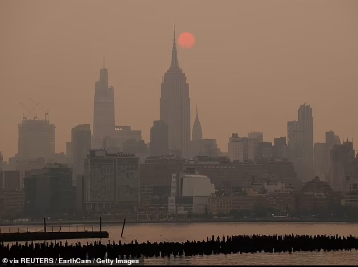
Yeah, I forgot about the sunsets. Hate the air being bad but there could be some good viewing.NYC today
Not much since you noted your lack a few weeks ago. I got .44” on Sunday right after I watered my garden. You could barely tell the next day.How much rain lately up that way?
Iceagewhereartthou
Member
Overall a pretty good week shaping up for early June, with several nights still in the 50s for many. Here is the forecast for 6000 feet in NC (Mt Hardy), pretty impressive for June!
Today
Scattered showers, with thunderstorms also possible after 4pm. Partly sunny, with a high near 61. West northwest wind 14 to 18 mph, with gusts as high as 22 mph. Chance of precipitation is 30%. New rainfall amounts of less than a tenth of an inch, except higher amounts possible in thunderstorms.
Tonight
Showers likely and possibly a thunderstorm before 8pm, then scattered showers. Patchy fog after 2am. Otherwise, mostly cloudy, with a low around 46. Breezy, with a north wind 16 to 21 mph decreasing to 9 to 14 mph after midnight. Winds could gust as high as 24 mph. Chance of precipitation is 60%. New precipitation amounts of less than a tenth of an inch, except higher amounts possible in thunderstorms.
Thursday
A slight chance of showers before 10am, then a slight chance of showers and thunderstorms between 10am and 2pm, then a slight chance of showers after 2pm. Patchy fog before 8am. Otherwise, mostly sunny, with a high near 56. North northwest wind 7 to 9 mph. Chance of precipitation is 20%.
Thursday Night
Mostly clear, with a low around 43. North wind 9 to 13 mph, with gusts as high as 20 mph.
Friday
Sunny, with a high near 59. Northwest wind 9 to 11 mph, with gusts as high as 20 mph.
Friday Night
Mostly clear, with a low around 45.
Saturday
Sunny, with a high near 63.
Saturday Night
Mostly clear, with a low around 51.
Sunday
A 40 percent chance of showers after noon. Mostly sunny, with a high near 62.
Sunday Night
Showers likely before 7pm, then showers likely and possibly a thunderstorm between 7pm and midnight, then showers likely after midnight. Mostly cloudy, with a low around 54. Chance of precipitation is 70%.
Monday
Showers and thunderstorms likely. Partly sunny, with a high near 62. Chance of precipitation is 70%.
Monday Night
A 30 percent chance of showers and thunderstorms. Partly cloudy, with a low around 48.
Tuesday
Sunny, with a high near 64.
There have been some storms all around me the past few days, but I haven't any rain since May 23rd.Not much since you noted your lack a few weeks ago. I got .44” on Sunday right after I watered my garden. You could barely tell the next day.
Last edited:
severestorm
Member
Wow!
NYC:

NYC:
I drove home from Ellijay to Calhoun yesterday and a lot of the corn fields look pitiful. They got good rain on Sunday but its starting to distress the plants.There have been some storms all around me the past few days, but I haven't any rain since May 23rd.
Somebody has a nice filter on.Wow!
NYC:
NoSnowATL
Member
I have a mars filter on my iPhone too.Somebody has a nice filter on.
NoSnowATL
Member
My friend just sent me this from NY. He lives on the 24th floor. ?

Last edited:
severestorm
Member
it's not a filterSomebody has a nice filter on.
https://www.earthcam.com/usa/newyork/skyline/?cam=skyline_g
???
Another sweatshirt morning. June 8th/ Go figure. Don't see a 90 on the horizon still for MBY. Gitty -Up!
BufordWX
Member
Been pretty dry since I’ve been back in Georgia the past month. Might be some chance at some good rains next week though.
Going to be close to getting into the 40s tonight.