Extremely heavy rates up to 4” per NWS. North-west NC is getting nailed.
-
Hello, please take a minute to check out our awesome content, contributed by the wonderful members of our community. We hope you'll add your own thoughts and opinions by making a free account!
You are using an out of date browser. It may not display this or other websites correctly.
You should upgrade or use an alternative browser.
You should upgrade or use an alternative browser.
Pattern July
- Thread starter Metwannabe
- Start date
Going to need a Flash Flood Warning for Watauga, Ashe and Alleghany.
They are getting pounded in the ?Going to need a Flash Flood Warning for Watauga, Ashe and Alleghany.
Getting excited about tomorrows rain chances!
Hrrr gets a loosely organized QLCS tomorrow afternoon in NC, also has the LP in NC which may enhance wind shear just a bit, And adds potential to that random vortex that pops up which adds to the damaging wind threat
?Hrrr gets a loosely organized QLCS tomorrow afternoon in NC, also has the LP in NC which may enhance wind shear just a bit, And adds potential to that random vortex that pops up which adds to the damaging wind threat
I'd like to but I've seen this movie. Tomorrow's choices for fail are the front gets here too soon and the storms fire to the east, storms fire to the west and become outflow dominant so its wind and stratiform around here as the line reorganizes the the east. The line breaks up a bit from being linear and gets more of a line segment/weak supercell look and I am in the middleGetting excited about tomorrows rain chances!
Sent from my SM-G975U using Tapatalk
Should be good coverage tomorrow but it's also convective so there will be holes..... let's hope Greenville, SC, Harnett Co, NC and southern Wake Co aren't in those holes

Looking at CAM's this seems somewhat probable..... unfortunatelyI'd like to but I've seen this movie. Tomorrow's choices for fail are the front gets here too soon and the storms fire to the east, storms fire to the west and become outflow dominant so its wind and stratiform around here as the line reorganizes the the east. The line breaks up a bit from being linear and gets more of a line segment/weak supercell look and I am in the middle
Sent from my SM-G975U using Tapatalk
Should be good coverage tomorrow but it's also convective so there will be holes..... let's hope Greenville, SC, Harnett Co, NC and southern Wake Co aren't in those holes
View attachment 21222

If whatever reason I think of moving and in that senior moment I consider southern Wake Co. please find me and slap me silly....
Hey now I'm in the pinky purple...I keep
Sent from my SM-G975U using Tapatalk
Rain cold...aleet aleet dark cloud on the horizon alert

Sent from my SM-G975U using Tapatalk

Sent from my SM-G975U using Tapatalk
Shaggy
Member
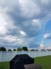
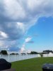
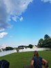
Perfect visualization of the seabreeze and its cleansing effect on the atmosphere. The first pic is just in front of the breeze middle is right along the wind shift and the pic to the right is the clear blue sky.
Attachments
Watch the efficiency at which it dissipates as works into the air sink zone.Rain cold...aleet aleet dark cloud on the horizon alert
Sent from my SM-G975U using Tapatalk
Nailed itWatch the efficiency at which it dissipates as works into the air sink zone.


Sent from my SM-G975U using Tapatalk
Like a fart in the wind
Meanwhile, the ones near 95 have been just happily redeveloping and tracking over virtually the same areas. This happens far too often to be merely chance and happenstance.
Well I was going to ----- about Phoenix being under a severe tstorm watch. Then I looked at their June and July so far... good for themMeanwhile, the ones near 95 have been just happily redeveloping and tracking over virtually the same areas. This happens far too often to be merely chance and happenstance.
Sent from my SM-G975U using Tapatalk
JHS
Member
Just got .29 here from an isolated storm.