tropical tidbits and pivotal weather are good optionsWhere is the best place to view the hrrr... I used to view on weather bell but can't anymore.
Sent from my Pixel 4 using Tapatalk
-
Hello, please take a minute to check out our awesome content, contributed by the wonderful members of our community. We hope you'll add your own thoughts and opinions by making a free account!
You are using an out of date browser. It may not display this or other websites correctly.
You should upgrade or use an alternative browser.
You should upgrade or use an alternative browser.
July Surprise!
- Thread starter Ollie Williams
- Start date
Surprised that isn't centered over Knoxville600dm ridge? Ouch.

Sent from my iPhone using Tapatalk

Really wasn't expecting the radar to be lighting up this early
cd2play
Member
Might as well get it while you can, because August will probably dry out and flirt with 100s.It just won’t stop raining here . ( still in GSP) it’s been drizzling or raining since about 5pm yesterday after a few heavy downpours yesterday morning!
cd2play
Member
That's what she saidReally wasn't expecting the radar to be lighting up this early
NBAcentel
Member
looks like the moist profiles/skinny cape is killing lightning production
GeorgiaGirl
Member
2" so far
Bannerdude
Member
Distinct mesolow rotation on radar W of Florence
looks like the moist profiles/skinny cape is killing lightning production
I haven't heard thunder since last week. That's just pathetic if you ask me, especially being in the south. Can someone throw us a damn bone, already?!
What is my weather lady wearing? ? 
JHS
Member
May have to wait at least 2-3 days if not longer. Cloud cover not helping today and subsidence behind this low means little coverage tomorrow. The 60-70% chance for today and tomorrow is way overdone. Should be no higher than 20% for most areas north of I-85. The coast will have better chances both days of course. This low turned to the east too early to help northern areas out. If the NC folks miss the 1 band out there now, they'll have to wait at least until Thursday or Friday for a decent chance of rain. The steady rain from this low stays south of a Rockingham Morehead city line in NC.I haven't heard thunder since last week. That's just pathetic if you ask me, especially being in the south. Can someone throw us a damn bone, already?!
May have to wait at least 2-3 days if not longer. Cloud cover not helping today and subsidence behind this low means little coverage tomorrow. The 60-70% chance for today and tomorrow is way overdone. Should be no higher than 20% for most areas north of I-85. The coast will have better chances both days of course. This low turned to the east too early to help northern areas out. If the NC folks miss the 1 band out there now, they'll have to wait at least until Thursday or Friday for a decent chance of rain. The steady rain from this low stays south of a Rockingham Morehead city line in NC.
Yeah, that's what I am thinking. Thursday looks good for some decent convection. Let's just hope it sets up over us. WE all deserve it. Hey, at least it's raining. And the majority of the extended forecast looks active. I do hope we can at least get an MCS or two in before August.
NBAcentel
Member
Really sucks living in CLT right now, TCLT is down, KGSP is down for maintenance, KCAE radar coverage here is terrible, it’s so bad
Shaggy
Member
Hrrr clearly under did coverage in its earlier runs that left me dry. I have some hopeful showers to my SE that are moving this way. Hoping they hold together.
Really sucks living in CLT right now, TCLT is down, KGSP is down for maintenance, KCAE radar coverage here is terrible, it’s so bad
Yeah, I noticed that. We just cannot win. Like, what did Charlotte do to deserve this treatment? ?
NoSnowATL
Member
Cloudy, light rain at times... the ball is rolling slow today.
Nice outflow... no rain
Welp looks like im going to take another L today... will be creeping up on a month soon enough
Welp looks like im going to take another L today... will be creeping up on a month soon enough
Don't worry you're not alone. We're all in this together!
Shaggy
Member
Welp looks like im going to take another L today... will be creeping up on a month soon enough
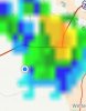
Has someone cursed me and you? Literally raining 2 miles to my east as the storm moves NNW barely east of me.
Attachments
I guess so. I'm getting annoyed, 4 out of the last 5 summers Ive had dry periods of over 3 weeks. Poops oldHas someone cursed me and you? Literally raining 2 miles to my east as the storm moves NNW barely east of me.
NoSnowATL
Member
LuckyI guess so. I'm getting annoyed, 4 out of the last 5 summers Ive had dry periods of over 3 weeks. Poops old
You can have itLucky
NBAcentel
Member
So I ask this question once again, what’s a thunderstorm and do they effect concord NC ?
Shaggy
Member
I guess so. I'm getting annoyed, 4 out of the last 5 summers Ive had dry periods of over 3 weeks. Poops old
I mean this is nuts. Literally can see rain falling across a big field that's maybe 1.5 miles from me to the tree line. Not a drop here.
Attachments
So I ask this question once again, what’s a thunderstorm and do they effect concord NC ?
I believe it's lots of loud sounds and sometimes light from the sky.
Dad just text me that he's at 1.25 today. Thats on top of 2.3 Saturday and .7 Sunday hes only 25 miles away. This blows, I can't even get a consolation prize moderate rain that's .25-.33I mean this is nuts. Literally can see rain falling across a big field that's maybe 1.5 miles from me to the tree line. Not a drop here.
Bannerdude
Member
This band over Moncure is puting out some chonky rain. Even heard a bonus rumble of thunder.
NBAcentel
Member
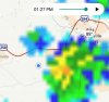
many times have I seen a radar image like this so far this summer, always to my north 
many times have I seen a radar image like this so far this summer, always to my north View attachment 43806
I am done with this summer.
BoomSun is shining here, CIN has eroded, SB/ML Capes are building, PWATS increasing to around 2 inches. Yep I bet we fail
My concern for today is we get big convection going from say MHX to FAY that barfs out an outflow boundary moving N and we start to see more isolated to scattered convection as it moves north.
Well after nearly an inch of rain here in southern Union County, the sun is trying to come out, so maybe we have enough to destabilize the atmosphere to get some good evening stormsWhy are POPS so high when it appears we are about to get dry slotted?
Well after nearly an inch of rain here in southern Union County, the sun is trying to come out, so maybe we have enough to destabilize the atmosphere to get some good evening storms
That's what I am hoping for, but I don't want to get too excited and then be disappointed once again.
Avalanche
Member
Impressive rains falling here in Pittsboro area
NBAcentel
Member
Saturday. Looks good, nice trough in place with up to 30kts of 500mb flow so maybe storms can form in the way we like off the mountains into the piedmont to ENC ? 


No. We will find some way to bungle it. Too little cape, ouflow, morning stratus, warm mid levels, poor lapse rates, too much sun, dew points too low, poor timing, godzilla something will happenSaturday. Looks good, nice trough in place with up to 30kts of 500mb flow so maybe storms can form in the way we like off the mountains into the piedmont to ENC ? View attachment 43812View attachment 43813View attachment 43814View attachment 43815
Shaggy
Member
Saturday. Looks good, nice trough in place with up to 30kts of 500mb flow so maybe storms can form in the way we like off the mountains into the piedmont to ENC ? View attachment 43812View attachment 43813View attachment 43814View attachment 43815
That doesn't happen anymore. When I was a kid it was at least 2 to 3 times a week we would get these lines from the piedmont that would hit around 5 or 6pm. Hours of stratiform afterwards with long rolling thunder.
GeorgiaGirl
Member
Well, I just wasted an hour out (as I didn't find what I wanted to find at that store) but as I was coming home I found myself in an intense rainstorm. That got my anxiety up and I'm just now starting to settle down.
NBAcentel
Member
Nice, loosing cape over a few raindrops and even when the sun is peeking out, love it ! ?