I'll update this if there is a surge in votes on the next 3 hours
-
Hello, please take a minute to check out our awesome content, contributed by the wonderful members of our community. We hope you'll add your own thoughts and opinions by making a free account!
You are using an out of date browser. It may not display this or other websites correctly.
You should upgrade or use an alternative browser.
You should upgrade or use an alternative browser.
July Fry 2021
- Thread starter SD
- Start date
- Status
- Not open for further replies.
I predict “July Fry” will end up a misnomer for the SE. Mark my words. Near normal July temperatures for the SE coming with near to wetter than normal/humid dominating. Soils are too wet for any big heatwaves. The main heat will be out west and to the north. Maybe @Dewpoint Dan and good chance @Webberweather53 and that Montana poster end up with a hot month.
accu35
Member
July "Fry" catfish?? Love it!!
NBAcentel
Member
Feel like we get a big surge in temps this July that’s short lived, just to much out west that can transfer here
Yeah I think we could multiple 1-2 day surges from the release of western heat, but I also could see a good NW flow storm pattern on the backside of those surges. I don’t believe we will see widespread triple digits in the southeast this year.Feel like we get a big surge in temps this July that’s short lived, just to much out west that can transfer here
Agreed thank god for the thread name finally something for and by the people! This is our July 4th freedom from @SDI predict “July Fry” will end up a misnomer for the SE. Mark my words. Near normal July temperatures for the SE coming with near to wetter than normal/humid dominating. Soils are too wet for any big heatwaves. The main heat will be out west and to the north. Maybe @Dewpoint Dan and good chance @Webberweather53 and that Montana poster end up with a hot month.
LickWx
Member
No Dookie Dan said august not July .120 on tap?
Dewpoint Dan
Member
Mid AugustNo Dookie Dan said august not July .
Doubt it just found the article interesting120 on tap?
LickWx
Member
If you read about the 2007 heat wave , heat index values did exceed 120 in eastern NC. So there is that at least .Doubt it just found the article interesting
I haven't read it yet. I just remember someone talking about 120 somewhere around here a couple days ago.Doubt it just found the article interesting
NBAcentel
Member

Nice. Got that one in just under the wire...unless that is a May shot.
")
Either way, I really like that one.
That’s another thing that made that so odd back here to the west, Typically when CLT gets triple digits, the humidity is at least down a bit… not in August 2007. There were quite a few times when temperatures were 102-104 and the heat indexes were around 110.If you read about the 2007 heat wave , heat index values did exceed 120 in eastern NC. So there is that at least .
NBAcentel
Member
Got lucky with a cell near Heath springs SC (storm died off now) but yeah crazy how it took till June 30th to get a shot lolNice. Got that one in just under the wire...unless that is a May shot.
Either way, I really like that one.
LickWx
Member
There was a town in Washington state that recorded an 82/82 temp/dew combo. It was humid when it was at its hottest but even they managed some high humidity at times .That’s another thing that made that so odd back here to the west, Typically when CLT gets triple digits, the humidity is at least down a bit… not in August 2007. There were quite a few times when temperatures were 102-104 and the heat indexes were around 110.
znel52
Member
At least 'July Thread' didn't win lol. PRAISE!
To go back to the historic heatwaves for NC and why we were talking about it potentially making a run at us here are the heatwave 500mb anomalies rolled back a few days past where NWS ILM showed roughly +7-10 days

and here is the GFS at 6 hours from this morning

Thankfully though this year we are likely not going drop a trough into the NW and push the heat east

500mb composite near or during the start of the heat

We were close to frying but all signs point to it not happening for now. Watch later in the month though as we may try to rotate through a similar evolution.
The euro does have a short heat run mainly for Va/mid Atlantic
.png")
.png")
.png")
and here is the GFS at 6 hours from this morning
Thankfully though this year we are likely not going drop a trough into the NW and push the heat east
500mb composite near or during the start of the heat
We were close to frying but all signs point to it not happening for now. Watch later in the month though as we may try to rotate through a similar evolution.
The euro does have a short heat run mainly for Va/mid Atlantic
Last edited:
Do you have KATLs heatwave data handy? I'm wondering if heat in GA, AL, TN, MS has a different mechanism where NC and much of SC aren't as hotI predict “July Fry” will end up a misnomer for the SE. Mark my words. Near normal July temperatures for the SE coming with near to wetter than normal/humid dominating. Soils are too wet for any big heatwaves. The main heat will be out west and to the north. Maybe @Dewpoint Dan and good chance @Webberweather53 and that Montana poster end up with a hot month.
NBAcentel
Member
July comes in with a bang like last year for lightning? Lol 
LickWx
Member
I’d wager at least parts of Georgia share their hottest temps in similar setups to us . Far north eastern , eastern Georgia perhaps . Atlanta South and sw probably not .Do you have KATLs heatwave data handy? I'm wondering if heat in GA, AL, TN, MS has a different mechanism where NC and much of SC aren't as hot

Yep was just about to post this … drought going bye bye fast .. and after the big wet #3 it should be a memory … add a tropical system later… the maps wiped clean .. here’s the 3km .. no more dry spot .. we’re about to get sockedNot bad for July. Hope it stay this way. US Drought Map SE
View attachment 85984

Cart horse... chickens hatchingYep was just about to post this … drought going bye bye fast .. and after the big wet #3 it should be a memory … add a tropical system later… the maps wiped clean .. here’s the 3km .. no more dry spot .. we’re about to get socked View attachment 85985
1) Not sure what your idea of "fast" is, for many areas it started back in April and hasn't gone bye bye just yetYep was just about to post this … drought going bye bye fast .. and after the big wet #3 it should be a memory … add a tropical system later… the maps wiped clean .. here’s the 3km .. no more dry spot .. we’re about to get socked View attachment 85985
2) All chips in the middle on the 3k NAM, I've seen worse wagers but also seems I've read these comments before
3) Definitely getting a tropical system in here next week? Got those lotto numbers?
4) Never mind.....
I need to learn from your succinctnessCart horse... chickens hatching
Tomorrow looks great for rainfall but in addition to the U. S. Drought monitor map posted above, here is the departure from normal over last 90 days. Trust me there are some hoping tomorrow isn't a let down....

cd2play
Member
I tend to think the heat ridge eventually visits the SE, giving us a spell of 95+, but I think it will be transit, lasting 5 days or less.
smast16
Member
Yep was just about to post this … drought going bye bye fast .. and after the big wet #3 it should be a memory … add a tropical system later… the maps wiped clean .. here’s the 3km .. no more dry spot .. we’re about to get socked View attachment 85985
Except for a dry slot forming in the northern half of Forsyth county, which happens to be where I live. That dry slot is showing in an area that's 4"-6" below normal for the last 90 days. And with my luck, it'll get in that minimum.
1. The worst drought we’ve really had show up is D2 in small areas and we’ve maintained just a slight as normally dry drought for this entire time … not that lethal of a thing1) Not sure what your idea of "fast" is, for many areas it started back in April and hasn't gone bye bye just yet
2) All chips in the middle on the 3k NAM, I've seen worse wagers but also seems I've read these comments before
3) Definitely getting a tropical system in here next week? Got those lotto numbers?
4) Never mind.....
2. Not all my chips ..here are the cams along with the most recent HRRR and most recent Fv3 high res which show all across the board a widespread 1-2 inches with many places receiving pockets of 3-4 inches as well. A widespread 1-2 inches is a beautiful thing for a drought that’s only abnormally dry. Also Fv3 wasn’t done running yet


3. I’m not saying we’re definitely getting a tropical system next week but several models have a lot of ensemble tracks that pull it in our direction .. whatever the system may be it’ll bring tropical moisture with it and if we’re lucky that would certainly put drought to
Bed if it wasn’t already … abnormally dry ain’t that bad it could be severely worse! ??

You got me1. The worst drought we’ve really had show up is D2 in small areas and we’ve maintained just a slight as normally dry drought for this entire time … not that lethal of a thing
2. Not all my chips ..here are the cams along with the most recent HRRR and most recent Fv3 high res which show all across the board a widespread 1-2 inches with many places receiving pockets of 3-4 inches as well. A widespread 1-2 inches is a beautiful thing for a drought that’s only abnormally dry. Also Fv3 wasn’t done running yet View attachment 85987View attachment 85988View attachment 85989View attachment 85990
3. I’m not saying we’re definitely getting a tropical system next week but several models have a lot of ensemble tracks that pull it in our direction .. whatever the system may be it’ll bring tropical moisture with it and if we’re lucky that would certainly put drought to
Bed if it wasn’t already … abnormally dry ain’t that bad it could be severely worse! ??
Indeed. It's a hard time of the year to overcome dry conditions as we are maxed out on our usage side of the water budget. A inch of rain tomorrow will be great things will be green, crops will get some water but it's can kicking and maintenence. Much rather have a week of scattered to numerous storms to get 2 or 3 rains to recharge versus 1 rain then 5-7 days of nada.Tomorrow looks great for rainfall but in addition to the U. S. Drought monitor map posted above, here is the departure from normal over last 90 days. Trust me there are some hoping tomorrow isn't a let down....
View attachment 85986
Look at it this way each day .15-.2 of water is used/lost if we get 1 inch of rain it's gone in 5-7 days. It's hard to make up multi inch deficits when you are equalling your use. I received 5 inches of rain in June my yard used/lost 4.5-6 inches of rain in the month, I broke even, given the dry April/May my 90 day budget is negative hence the d0-1 around. I get 1 inch of rain tomorrow good, by 7/6 if I get no more rain my net is 0 I'm "dry" again
Last edited:
True true true .. good explanation .. I think we get more than 1 though but of course we’ve been through this rodeo before so I’ll believe the numbers when I see them … also that 5-7 day end period would probably be around when we could possibly get that tropical whatever from Elsa … we’ve had good luck so far this year .. let’s keep it rollingIndeed. It's a hard time of the year to overcome dry conditions as we are maxed out on our usage side of the water budget. A inch of rain tomorrow will be great things will be green, crops will get some water but it's can kicking and maintenence. Much rather have a week of scattered to numerous storms to get 2 or 3 rains to recharge versus 1 rain then 5-7 days of nada.
Look at it this way each day .15-.2 of water is used/lost if we get 1 inch of rain it's gone in 5-7 days. It's hard to make up multi inch deficits when you are equalling your use. I received 5 inches of rain in June my yard used/lost 4.5-6 inches of rain in the month, I broke even, given the dry April/May my 90 day budget is negative hence the d0-1 around. I get 1 inch of rain tomorrow good, by 7/6 if I get no more rain my net is 0 I'm "dry" again
If we get multiple inches that'll certainly be helpful. I personally think Elsa goes otsTrue true true .. good explanation .. I think we get more than 1 though but of course we’ve been through this rodeo before so I’ll believe the numbers when I see them … also that 5-7 day end period would probably be around when we could possibly get that tropical whatever from Elsa … we’ve had good luck so far this year .. let’s keep it rolling
Just remember, when he speaks of "drought", he means the dust bowl death to scorpion droughts that persist underneath the mega heat dome of doom not this penny ante abnormally dry crap.If we get multiple inches that'll certainly be helpful. I personally think Elsa goes ots
NBAcentel
Member


LickWx
Member
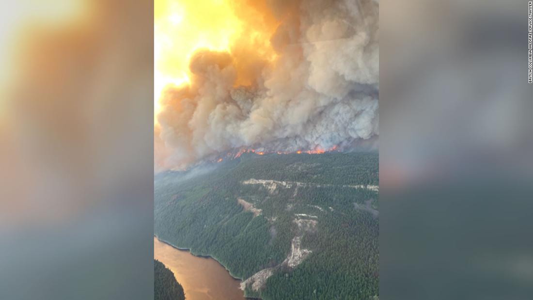
Town that recorded 121 degrees , Lytton bc , is on fire . Towns gone now . Geez . Entire town has been destroyed .
 www.google.com
Canadian village 'devastated' by wildfires a day after temperatures topped 121 degrees
The Canadian village that set an all-time national heat record this week has been "devastated" by a fast-moving wildfire that engulfed the small town "within minutes" following an intense heat wave, officials said Thursday.
Redirect Notice
www.google.com
- Status
- Not open for further replies.