BufordWX
Member
Confirmed tornado in LA
Yikes, terrible weather for the people in Louisiana today. Torrential tropical downpours and tornadoes.
Confirmed tornado in LA
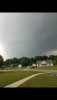
Southeast of that low in Louisiana that line of storms has a good bit of rotating storms in it. I count 4 Tornado warnings there currently.View attachment 20144

Wata wedge
The skies have opened up here with very heavy rains from a thunderstorm, the heaviest rain in quite some time. CTG lightning has been occurring.
Can you send some of that rain here? Best I have gotten the last two days is mist and drizzle.The skies have opened up here with very heavy rains from a thunderstorm, the heaviest rain in quite some time. CTG lightning has been occurring.

Can you send some of that rain here? Best I have gotten the last two days is mist and drizzle.
Yeah ... the UF Ag and Met offices are really talking this one up today ...WPC still has some impressive totals for the next 7 days. View attachment 20158


? thats going to feel good lol
Yes, in a word ... with luck and prayer and a non-land falling asteroid ...60s for lows next week... can we keep this coming all summer?
Radar is getting a little interestingSounds like a storm is brewing here. Just had some loud rumbles of thunder.
Radar is getting a little interesting
Sent from my SM-G955U using Tapatalk
Very IconishRadar is getting a little interesting
Sent from my SM-G955U using Tapatalk
A little too iconic....don't you thinkVery Iconish
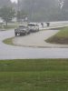
This looks awesomeI just had one of my worst storms in years. Nothing super strong in the wind department but I had atleast 5 strong downbursts and could smell broken trees. Precip was ridiculous and filled my neighbors ditch in no time. Totally caught me off guard as there was never a warning on the storm. I got a video or 2 I'm downloading.
This looks awesome
Sent from my SM-G955U using Tapatalk


Damn, something weather related. Happy days ...SPC latest update has expanded marginal risk a bit to the north to include east MS, almost all of AL, and west GA. Main risk is strong winds and maybe a spin up tornado.View attachment 20207View attachment 20206
SPC latest update has expanded marginal risk a bit to the north to include east MS, almost all of AL, and west GA. Main risk is strong winds and maybe a spin up tornado.View attachment 20207View attachment 20206

View attachment 20209
Mesoscale Discussion 1011
NWS Storm Prediction Center Norman OK
0806 PM CDT Thu Jun 06 2019
Areas affected...east-central MS...central AL
Concerning...Severe potential...Watch unlikely
Valid 070106Z - 070200Z
Probability of Watch Issuance...20 percent
SUMMARY...Transient supercells will be capable of intermittent
strengthening of low-level mesocyclones with the strongest updrafts.
A brief/weak tornado is possible this evening. The isolated
character and magnitude of the threat will probably preclude the
need for a small tornado watch.
DISCUSSION...Radar mosaic shows a band of convection, from
north-central MS southeastward into west-central AL, with embedded
discrete cores immediately east of a surface low over east-central
MS. Surface observations show backed southeasterly surface winds
east of the ongoing convective activity. KBMX VAD show the
low-level winds acting to enlarge the hodograph (around 200 m2/s2
0-1km SRH). The 00z Birmingham, AL raob showed a very moist/deep
boundary layer with just over 100 J/kg MLCAPE, all located below
500mb. The equilibrium level (based on a 100mb mean parcel) is just
below the -20 degrees C level and would likely not support much
lightning with the stronger updrafts. The moist-adiabatic lapse
rate/pseudo tropical profile will not cool substantially during the
evening.
As a belt of modestly strong, southerly 850mb flow shifts northward
across central and then into north-central AL and northwest GA
through the late evening, expecting episodic strengthening of small
mesocyclones in the very moist airmass over far east-central MS in
the near term and later into parts of central AL. A brief/weak
tornado may accompany the strongest circulations.