Top of the thread first page.Where do we find the polls?!
Sent from my iPhone using Tapatalk
-
Hello, please take a minute to check out our awesome content, contributed by the wonderful members of our community. We hope you'll add your own thoughts and opinions by making a free account!
You are using an out of date browser. It may not display this or other websites correctly.
You should upgrade or use an alternative browser.
You should upgrade or use an alternative browser.
Pattern Januworry
- Thread starter SD
- Start date
kstrickland0823
Member
Top of the thread first page.
Thank you! It wasn’t showing from mobile version so I had to click on web version!!
Sent from my iPhone using Tapatalk
I wonder if it was a cache thing?Thank you! It wasn’t showing from mobile version so I had to click on web version!!
Sent from my iPhone using Tapatalk
Prestige Worldwide
Member
L
Logan Is An Idiot 02
Guest
Don’t get too excited- maybe 2 weeks of fun
Honestly the story of every single winter in the southeast. Endless west coast troughs and a tiny 1-2 to week window of below average temps and a chance of a little wintry weather. Honestly a joke. But it’s the southeast what more can you expect
Don’t get too excited- maybe 2 weeks of fun
Even if it was only for 2 weeks that’s a long time for many things to happen and we will have much much time to get a good pattern going again later in winter as well since we are only going to be run late December early January
It may not work in tapatalkI wonder if it was a cache thing?
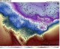
Wow that CFS run last night was a doozy .. we got a major snow storm with temps around 11-15 degrees when snow starts. Uh wow .. then once snow ends temps plummet to -10 or so for many SE locations .. but don’t worry we warm up that week .. from hour 588- the end of the run temps for highs remain below 20 or around 20 degrees for highs and lows dip below zero to single digits every night … talk about living in the arctic .. a run from fantasy heaven if that transpired we wouldn’t know what to do .. first pic is right after snowfall and second is the end of the run (warmest temps since the storm started) 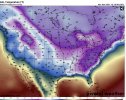


JHS
Member
Looks like a colder version of 1982 to me. For many of us those lows would even beat out the Jan 1985 cold snap.
Yeah, I don't think I've ever seen a model run that cold for the SE; and for the length of the cold snap. Ponds and lakes would freeze over. It would be cool to see something like that..Wow that CFS run last night was a doozy .. we got a major snow storm with temps around 11-15 degrees when snow starts. Uh wow .. then once snow ends temps plummet to -10 or so for many SE locations .. but don’t worry we warm up that week .. from hour 588- the end of the run temps for highs remain below 20 or around 20 degrees for highs and lows dip below zero to single digits every night … talk about living in the arctic .. a run from fantasy heaven if that transpired we wouldn’t know what to do .. first pic is right after snowfall and second is the end of the run (warmest temps since the storm started) View attachment 98448View attachment 98449
Snowman63
Member
Wow that CFS run last night was a doozy .. we got a major snow storm with temps around 11-15 degrees when snow starts. Uh wow .. then once snow ends temps plummet to -10 or so for many SE locations .. but don’t worry we warm up that week .. from hour 588- the end of the run temps for highs remain below 20 or around 20 degrees for highs and lows dip below zero to single digits every night … talk about living in the arctic .. a run from fantasy heaven if that transpired we wouldn’t know what to do .. first pic is right after snowfall and second is the end of the run (warmest temps since the storm started) View attachment 98448View attachment 98449
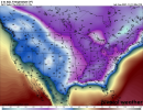
Here is the previous 24 hours... Jackson, Ms. -22 and Baton Rouge, La. -15 ?
Dewpoint Dan
Member
It's somehow colder in Southern Louisiana than in Northern Minnesota.Here is the previous 24 hours... Jackson, Ms. -22 and Baton Rouge, La. -15 ?
View attachment 98451
Just quickly looking at it that run would probably be the all time record low at rdu, all time record low max, quite a few daily record lows, and it would be close to most hours below freezing and most days with snow cover. It would really be a once in a lifetime cold event to be honest and I'm here for itYeah, I don't think I've ever seen a model run that cold for the SE; and for the length of the cold snap. Ponds and lakes would freeze over. It would be cool to see something like that..
LovingGulfLows
Member
- Joined
- Jan 5, 2017
- Messages
- 1,499
- Reaction score
- 4,100
Here is the previous 24 hours... Jackson, Ms. -22 and Baton Rouge, La. -15 ?
View attachment 98451
That would have to be mean those areas have snow on the ground or at least that's what the CFS is hinting at. Regardless, it's is incredibly unrealistic and unlikely.
Here is the previous 24 hours... Jackson, Ms. -22 and Baton Rouge, La. -15 ?
View attachment 98451
The coldest on record at Jackson, MS, is -5 F set on 1/27/1940 just after their heaviest snow on record of 10.5” set 1/22-23. The coldest on record way up at Chicago is -27 F. So, of course we all know that CFS modeled -22 F is not even close to being realistic. I wonder if the 2M output on Pivotal is similar to what WxBell shows, which I know shows CFS extremes much larger than CFS 2M maps I see as I’ve commented. If so, this is likely not even a CFS issue per se but instead an issue related to flaws in how the 2M temperature maps are generated by certain providers. Maybe it is that temperatures over snowcover are unrealistically way too cold. I’ve seen that problem before even with the Euro though not this bad.
I look at this run as extremely cold but I’m certainly not believing the coldest 2M numbers in the SE as realistic. I suspect the algorithm for snow cover induced cooling is flawed.
Last edited:
The infrastructure damage would be insane.Here is the previous 24 hours... Jackson, Ms. -22 and Baton Rouge, La. -15 ?
View attachment 98451
The real question is whether or not the CFS has ever had a prior run modeled this cold before? If it did, what actually happened in the weeks that followed.The coldest on record at Jackson, MS, is -5 F set on 1/27/1940 just after their heaviest snow on record of 10.5” set 1/22-23. The coldest on record way up at Chicago is -27 F. So, of course we all know that CFS modeled -22 F is not even close to being realistic. I wonder if the 2M output on Pivotal is similar to what WxBell shows, which I know shows CFS extremes much larger than CFS 2M maps I see as I’ve commented. If so, this is likely not even a CFS issue per se but instead an issue related to flaws in how the 2M temperature maps are generated by certain providers. Maybe it is that temperatures over snowcover are unrealistically way too cold. I’ve seen that problem before even with the Euro though not this bad.
I look at this run as extremely cold but I’m certainly not believing the coldest 2M numbers as realistic.
0% chance my pipes could survive something like that. No amount of drip would save me here. Thankfully, this could never happen.Here is the previous 24 hours... Jackson, Ms. -22 and Baton Rouge, La. -15 ?
View attachment 98451
LickWx
Member
Would be worse than what happened in Texas. There wouldn't be a single tree left alive in the south except for a few red maples or something lol. We would have to change the NC state tree from the pine to the maple or something.100% chance my pipes could survive something like that. No amount of drip would save me here. Thankfully, this could never happen.
Dewpoint Dan
Member
It "could" happen but probably won't. I give it a 10% chance of verifying.0% chance my pipes could survive something like that. No amount of drip would save me here. Thankfully, this could never happen.
LickWx
Member
I cant compare intensity but I have seen the CFS at that range show temps that cold plenty of times before. Honestly every year, last year might be an exeption I cant recall if I ever saw that last year.The real question is whether or not the CFS has ever had a prior run modeled this cold before? If it did, what actually happened in the weeks that followed.
It "could" happen but probably won't. I give it a 10% chance of verifying.
Lmao, 10% chance that Jackson, MS, gets down to -22? You must be trolling. You can’t possibly believe that.
Dewpoint Dan
Member
One thing I've learned is that the weather just keeps getting crazier every year. We are living in strange times. Nothing would surprise me.Lmao, 10% chance that Jackson, MS, gets down to -22? You must be trolling. You can’t possibly believe that.
I cant compare intensity but I have seen the CFS at that range show temps that cold plenty of times before. Honestly every year, last year might be an exeption I cant recall if I ever saw that last year.
What provider’s maps are you referring to? Any one in particular? The snowcover induced cooling algorithms could easily be flawed way too cold.
LickWx
Member
Pivotal weather is what I look atWhat provider’s maps are you referring to? Any one in particular? The snowcover induced cooling algorithms could easily be flawed way too cold.
Mr. Golf
Member
What provider’s maps are you referring to? Any one in particular? The snowcover induced cooling algorithms could easily be flawed way too cold.
Larry, nw Arkansas got down to -22 last February so it can be done in the south. Just not often enough unfortunately
Pivotal weather is what I look at
Ok, thanks. That’s all I need to know. So, from what you’re saying, this isn’t even an extraordinarily cold CFS run on Pivotal
LickWx
Member
In terms of how cold it got no, but how long it lasted ? I’m not sure , I can’t recall if I ever saw it show something that lasted 200+ hours .Ok, thanks. That’s all I need to know. So, from what you’re saying, this isn’t even an extraordinarily cold CFS run on Pivotal
Dewpoint Dan
Member
And it's been close to -20 in MS and close to -30 in AL before.Larry, nw Arkansas got down to -22 last February so it can be done in the south. Just not often enough unfortunately
LickWx
Member
In very very specific locations that make up probably .0001% of the states land area . New market Alabama has the record at -24 near Huntsville . -24 is not that close to -30 so a bit misleading .And it's been close to -20 in MS and close to -30 in AL before.
Larry, nw Arkansas got down to -22 last February so it can be done in the south. Just not often enough unfortunately
Fayetteville, AR, which got down to -22 last Feb, is 350 miles NW of Jackson and 1,100 feet higher elevation than Jackson. And to repeat, the coldest on record at Jackson is “only” -5 and that was over their deepest snowcover on record by a wide margin.
Dewpoint Dan
Member
I think it was -27 in New MarketIn very very specific locations that make up probably .0001% of the states land area . New market Alabama has the record at -24 near Huntsville . -24 is not that close to -30 so a bit misleading .
And the cold air doesn't have to cross the mountains in those locations.In very very specific locations that make up probably .0001% of the states land area . New market Alabama has the record at -24 near Huntsville . -24 is not that close to -30 so a bit misleading .
Mr. Golf
Member
Regardless, those cold patterns are anomalies for a reason. Got to have the right atmospheric conditions to allow that to occur.
Snowman63
Member
There's quite a bit of difference between Jackson, Ms. and NW Arkansas. lolLarry, nw Arkansas got down to -22 last February so it can be done in the south. Just not often enough unfortunately
Mr. Golf
Member
I just want 28-32 ,which is cold enough for snow and sleet and ice. Low teens in February was fun but very rare in snowing
LickWx
Member
New market Huntsville area is in the southern portion of the Cumberland plateau which provides perfect geography for exceptionally cold lows . With ridges to the west and the app mountains to the east.And the cold air doesn't have to cross the mountains in those locations.
Regardless, those cold patterns are anomalies for a reason. Got to have the right atmospheric conditions to allow that to occur.
But likely issues with forecast model map output algorithms shouldn’t be ignored. That’s 17 colder than their coldest on record, which itself was over deep snowcover.
Mr. Golf
Member
Just fun to look at I supposeBut likely issues with forecast model map output algorithms shouldn’t be ignored.
NBAcentel
Member

