lexxnchloe
Member
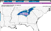
GFS very similar to ICON. really pretty good.

This said, if the trend on the Euro continues its DOA right now. Looks like the reverse of the normal trend continues to happen this year where the northern stream speeds up and the southern slows down. Not a good trend to be seeing start again.Still a big bomb off the coast. Still lots of time for this one to change.


Pretty classic Miller A setup.Yes, there’s definitely a good signal that there’s going to be a storm of some sort. What kind of support is there on the Euro and Canadian ensembles?


Arcc: Long range NAM is sooooo close across central AL early next week. A few degrees from 925mb to the surface….
Gonna be lots of shifts in every direction. I wouldn’t pay attention to shifts until 100 hours out. Just need the storm signal to still be there 100 hours out.


We really need to get out of this cranking up in NC stuff. Need this thing to start getting cranked back in Georgia.


I know I said I hated the setup yesterday, but I changed my mind. My concern is that this thing doesn't dig enough and can't develop until it gets to the northeast. Otherwise, lots of cold air is available.This sort of stuff excites me, the energy is already in Canada on Tuesday, this is about as good as a signal as you can get for this range, this has some big dog potential, everything is so classic. the western ridge, TPV near Hudson Bay, the hook. Woof View attachment 109630View attachment 109629