-
Hello, please take a minute to check out our awesome content, contributed by the wonderful members of our community. We hope you'll add your own thoughts and opinions by making a free account!
You are using an out of date browser. It may not display this or other websites correctly.
You should upgrade or use an alternative browser.
You should upgrade or use an alternative browser.
Pattern Januworry
- Thread starter SD
- Start date


The possibility of sustainable below freezing temps at the mid gulf coast is unreal.

Sent from my iPhone using Tapatalk

Sent from my iPhone using Tapatalk


Getting started early on the 00z GFS I see … wonderful
Jessy89
Member
Wish the cold make it a touch earlier on next weekend stuff
Sent from my iPhone using Tapatalk
Sent from my iPhone using Tapatalk
Storm5
Member
Not horrible , would like a taller ridge and the trough a bit west but at this lead I'll play

Sent from my iPhone using Tapatalk

Sent from my iPhone using Tapatalk
It’s close. Definitely needs some help.Not horrible , would like a taller ridge and the trough a bit west but at this lead I'll play
Sent from my iPhone using Tapatalk
brendan123
Member
DT says no for Thu/Fri. Still sets stage for future potential storms though.
dsaur
Member
Goofy keeps moving that low closer and closer to Fla., and that would bring Ga into the mix.Wish the cold make it a touch earlier on next weekend stuff
Sent from my iPhone using Tapatalk
So what do we have here? Just looking at precip maps looks like a low forming after a frontal pass? I don’t love the angle of cold here. Doesn’t really have time to build in the Carolinas verbatim. Maybe a chance to get that northern piece to dive in a bit further west, meet our southern piece and turn negative.Not horrible , would like a taller ridge and the trough a bit west but at this lead I'll play
Sent from my iPhone using Tapatalk
I guess the price we gotta play for seeing a 2 incher is a worse pattern than previous runs in the longer range. Haha 
Not encouraging that the CMC has a Big low near the Great Lakes while the GFS (which is known for being flat) is flat 

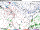
Someone help me out here. I’m not smart. Why the dual low pressure systems? The one to our north kills any chance at a dry cold air feed. 
Looks like the low on top is associated with northern stream energy, so it moved thru first just quick enough to start the process of CAA and a secondary area of low pressure developed to our SE and caused a little bit of overrunning actionSomeone help me out here. I’m not smart. Why the dual low pressure systems? The one to our north kills any chance at a dry cold air feed. View attachment 102853
Last edited:
GEFS barely supports the GFS 
Should be good news if the two inched gave us a worse patternGEFS barely supports the GFS View attachment 102856
Jessy89
Member
Fantasy Ice storm in long range all we get tonight
Sent from my iPhone using Tapatalk
Sent from my iPhone using Tapatalk
Shaggy
Member
I'd take that and its at least inside the 180hr mark so we wait for the euro to kill our hopes! These are the kind of events i expect to see around here to give us our yearly average