Prestige Worldwide
Member

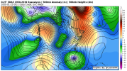
Not just any storm… January 2000. Note the colors pallet is skewed on the lower side (I had trouble with the anomaly algorithm when I made this)
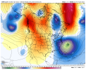
This is close right here. Move that low about 200-300 miles north and put that high over Michigan and you have a winter storm
Sent from my iPhone using Tapatalk


A lot can change in 3-4 days. Keep an eye ? on this one especially ENC and NE SC.View attachment 102888
Yeah,this is likely out to sea, but I can’t ignore it given typical NW trend and bombogenesis potential here. Plus, 850s were a lot colder this run.
Yeah I was about to go there with that storm but didn’t, glad you did. If this trough were further west and then went negative, ooh boy.Not just any storm… January 2000. Note the colors pallet is skewed on the lower side (I had trouble with the anomaly algorithm when I made this)
View attachment 102889
View attachment 102892
I doubt it would happen though.
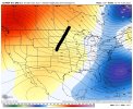
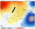
Brings me snow? I like this set up! But for real though this works out more when our first system blows up off into the NE almost backs up the whole flow and brings the cold air downMeh I don’t like the setup but View attachment 102893View attachment 102894
Hey Fro, that doesn’t look like 16”Meh I don’t like the setup but View attachment 102893View attachment 102894
Yeah overall setup is meh on the GFS at H5 but it can work in my eyes, it’s how many EPS members that showed NC snow evolved, and some blew it up off the coastHey Fro, that doesn’t look like 16”
That type of setup would probably be very marginal unless we have more cold wrap into the system via N/SBrings me snow? I like this set up! But for real though this works out more when our first system blows up off into the NE almost backs up the whole flow and brings the cold air down
A few days before Jan 2000 there was a burp or 2 from models for a possible novelty flake. All we had was tv mets back then.But itNot just any storm… January 2000. Note the colors pallet is skewed on the lower side (I had trouble with the anomaly algorithm when I made this)
View attachment 102889
View attachment 102892
I doubt it would happen though.
That would be a dream to experience. Unfortunately it’s 22 years later.A few days before Jan 2000 there was a burp or 2 from models for a possible novelty flake. All we had was tv mets back then.But it
completely vanished and from TV mets 3-5 day forecast as time drew nearer. Then that Monday I remember hearing early morning tv mets saying the models missed this northern stream diving energy by a 1000 miles. Ed Mathews. But dont sweat may get a few flakes latter in day. MiddaY snow starts breaking out Georgia up to Charlotte. By 4 to 5 pm Fishell is on air wral saying Raleigh is gonna see its biggest snow ever. Its snowing in eastern triad and local mets had us 1-3 on 6pm news. Heaviest would be down to Raleigh. Then the occlusion and pivot happens late that night. Woke up at sunrise Tuesday and 15 -18 inches was laying on the ground Randolph,eastern Guilford Alamance. Spent 7 long,cold days in the dark no power. We had a 2 tenths inch ice event that weekend preceeding and it was still on limbs. Caught every wet flake. As we where in the dark that Thursday another 5 incher came along.


Yeah, I think that now with all the short range models that refresh every 1-2 hours now, mets would be able to quickly react to and adjust forecasts a lot more quickly than as the 2000 storm unfolded. Even with that storm, I can remember Eric Thomas adding light snow to his Monday forecast for CLT metro on the Sunday 6pm newscast, then on the 11pm newscast he said that he thought that east of I-77 could see up to an inch of accumulation… there was already several inches on the ground from the storm that had just exited so he wasn’t concerned about a ton of additional impactsThat would be a dream to experience. Unfortunately it’s 22 years later.
