• Hello, please take a minute to check out our awesome content, contributed by the wonderful members of our community. We hope you'll add your own thoughts and opinions by making a free account!

Pattern January Joke

These models are on the struggle bus, they literally change every 6 hours for a 4-5 day event. Tough time handling these northern stream waves.


Sent from my iPhone using Tapatalk
It’s always difficult when we’re talking about the timing of multiple pieces of energy phasing together. I think it’s been even more difficult for them with less data going into the models
 
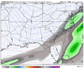
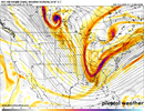
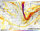
Pretty shocked at what the 09z RAP does with the first system, although it is an outlier. View attachment 182868
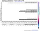
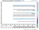
Footprint of the EURO …. Not insane. I still think with it all the energy flying around footprints merging on the models is the important thing still even for Thursday/Weekend. If they all start to paint the same footprint then we worry with QPF amounts. Again, jmo


Sent from my iPhone using Tapatalk
 
IMG_5836.pngIMG_5837.png
It’s definitely not very impressive and we are basically looking at a 20% chance right now but I’m happy to see the 1-3 inch members and not a bunch of trace members. We just need to hope the energy delivers and the qpf will increase leading up. I know are chances are slim but we aren’t out completely.
 
Umm… just a few more ticks and we rage?

View attachment 182864

Yeah gotta be careful. That look is not far from a number of very memorable events.

Just FWIW, three events off the top of my head are close to that look, 2014, 2017 and 2018. All three ticked up precip in the final few days and surprised.
 
Last edited:
Overrunning events usually sneak up on you at the last minute. Not too far off there

I knew you’d be here, pal. You harped on this happening weeks ago in the day 5ish range. Keep bringing the heat. There were only a very few of us who didn’t give up on this.
 
Meh, the Ukie ensembles sucked me in yesterday, and smacked me in the face the next run. Euro gives some hope for eastern sections the last 6z but I'm not falling for it. It's just so generally dry and progressive. Weekend is alive but on extreme life support imo.

More interesting to me is the Euro's insistence of a CAD ice storm in 10 days. That's usually how we roll.
 
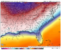
GFS & ICON..
Cold & Dry,

But, Wait, theres more!
Rates will over come!
Late Coastal Bloomer?

gfs_mslp_pcpn_frzn_us_9.pngicon_mslp_pcpn_frzn_us_19.png
 
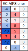
this may or may not wind up being relevant but just a note, in my last month or two of using the AIFS for temp forecasting it is consistently too warm at night, generally in the 3-5F range. whether it does this during precip events i am not certain, but it could be of note if this sort of situation came to fruition
1768311678253.png

1768311698578.png
here's the proof, left column is max temp error (i.e. verification was 60 while AIFS forecast 56, shows up as -4) and middle column is min temp error (i.e. verification was 38 while AIFS forecast 33, shows up as 5). ignore the rightmost column

1768311727204.png

i tend to think this error is probably smaller with precip falling but could still make a difference. again, not sure if this matters, but wanted to point it out in case it does end up mattering
 
The WeatherNext is intriguing. Considering it’s the most realible model, makes things more interesting.
 
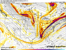
While in the end, who knows whether the differences showing up in Canada between models by day will make a difference of note for the weekend system.

The Euro and ICON have introduced yet another SW on the heels of system #2, poised to follow in its footsteps, while the GFS has yet a completely different closed UUL near Hudson Bay sliding eastward.

The point of my post is to point out that with such differences in Canada that have an influence on the PNA ridge and US trough orientation, the final forecast for the weekend is far from settled.
ecmwf_full-500hv-conus-2026011306-120.pngicon-500hv-conus-2026011306-120.pnggfs-500hv-conus-2026011306-120.png
 
IMG_5500.jpeg
I had to look it up, but the way these short range models are starting to hint for some areas on Thursday kinda reminds me of this one. This event completely started popping up in the last 48 hours and in fact some local mets here in CLT didn’t even forecast it within 12 hours
 
What percentage of time would you say, if you had to guess, do the ultra short range models like the HRRRRr and the RAP wildly overdo QPF at the end of their range. If you had to guess.
 
What percentage of time would you say, if you had to guess, do the ultra short range models like the HRRRRr and the RAP wildly overdo QPF at the end of their range. If you had to guess.
The RAP is always too cold. Unless it has changed since I last looked at it years ago.
 
Back
Top