NBAcentel
Member
So fickle. Honestly if the AIFS ens follows its OP, I’m not exactly gonna be swayed by the euro. I noticed the AIFS shorter term trends in winter storms last winter were often very on point
So fickle. Honestly if the AIFS ens follows its OP, I’m not exactly gonna be swayed by the euro. I noticed the AIFS shorter term trends in winter storms last winter were often very on point

It's my fav model in the offseason, just watching it for outdoor activities / rain etc. Not enough winter experience with it this season lolSo fickle. Honestly if the AIFS ens follows its OP, I’m not exactly gonna be swayed by the euro. I noticed the AIFS shorter term trends in winter storms last winter were often very on point


We still got around a week to reel that 2nd system in, I wouldnt worry too much at this range. But it is something we have to keep an eye on.Man we gotta get that second timeframe back. Thats the back up plan for many. It sucked losing that overnight. Another day of tracking ahead..


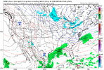
Yeah, liked like slight improvements with the 6z euro and Euro AI with the upper features, but no improvements at the surface. It’s not going to take many tweaks to get us something for one of those systems.Man only if we could slow this thing down with this amplification trend… View attachment 182155

Yeah this is a lot of jumps at H5 still for the range it’s at… gotta hope we jump to something good within the next 2 days. Looks like we should start getting better data on the energy starting around sun evening-Mon morning.Yeah, liked like slight improvements with the 6z euro and Euro AI with the upper features, but no improvements at the surface. It’s not going to take many tweaks to get us something for one of those systems.
 I think slowing down and going ham with the northern stream sort of like Jan 2018 is still on the table here… that one had a lot of changes on modeling even till the day of due to how difficult it is for models to grasp the northern branch. If we want to dig that thing more, I’d say strengthen the northern periphery of the PNA ridge and lean it negative tilt more to dive the northern stream wave equatorward


That basically appears to be the only shot. I wish we had some blocking. We'll need to stop running energy across the top of the Pac ridge or things will just end up being too progressive.Yeah this is a lot of jumps at H5 still for the range it’s at… gotta hope we jump to something good within the next 2 days. Looks like we should start getting better data on the energy starting around sun evening-Mon morning. View attachment 182157I think slowing down and going ham with the northern stream sort of like Jan 2018 is still on the table here… that one had a lot of changes on modeling even till the day of due to how difficult it is for models to grasp the northern branch. If we want to dig that thing more, I’d say strengthen the northern periphery of the PNA ridge and lean it negative tilt more to dive the northern stream wave equatorwardView attachment 182158View attachment 182159
it's got too.Man. Gotta think this MJO pulse keeps us in the game going into February.
Just below 2 inches here, thinking 3 plus I very doable.2” so far from this event. Feels like a mid morning in May.
2” so far from this event. Feels like a mid morning in May.

Its in the low 60s here, doesn't feel like January whatsoever.2” so far from this event. Feels like a mid morning in May.
2.18 so far here.Just below 2 inches here, thinking 3 plus I very doable.
I’m pushing three with thunder and the creek is at the top of its banks. We may make a run at five judging by the future radar.2” so far from this event. Feels like a mid morning in May.


I am just amazed that at 9:15ET in South Fulton that is 68F/cloudy and muggy. Much needed rain though!Sitting right at 2.60 so far with this event. Not going to complain. We all desperately need to rain in the South. It was down right depressing seeing how much Lake Lanier was down visiting the in-laws during Christmas. Also, low level clouds moving at a quick pace this morning. Anyway, now onto looking at trends on models today. Thank you all for your analysis!!!
You can already tell our next cold period starting around 360hrs… is potentially gonna be more favorable for snow. Ensemble means lighting up with snow at the very end of their runs.
MJO should be helping us out by that point and we have the cold source region. It’s probably going to be our make or break time this winter (last week of January/first week of February).
2.18 so far here.