It’s amazing we posted essentially the same idea only seconds apart!
-
Hello, please take a minute to check out our awesome content, contributed by the wonderful members of our community. We hope you'll add your own thoughts and opinions by making a free account!
You are using an out of date browser. It may not display this or other websites correctly.
You should upgrade or use an alternative browser.
You should upgrade or use an alternative browser.
Pattern January Joke
- Thread starter SD
- Start date
CNCsnwfan1210
Member
That’s what you call flipping the script
Sent from my iPhone using Tapatalk

NBAcentel
Member
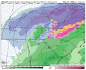
That’s wild that you can see cold air damming on a long range smoothed mean like thatToday’s Euro Weeklies for much of mid to late Jan:
View attachment 180410
Just 2 weirdos hahaIt’s amazing we posted essentially the same idea only seconds apart!
The weakening from Jan 5-12 matches up well with SPV weakening precursor patterns of North Pac Low / Greenland High / Urals Ridge


NBAcentel
Member
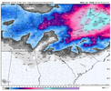
Think maybe the Aleutian trough showing up is disturbing the SPV ? Technically troughing in the sector around the Bering sea/Aleutian Islands is a thorn to the SPVToday’s Euro Weeklies’ SPV at 10 mb is even weaker based on mean zonal 60N winds:
One week ago:
View attachment 180408
Today: note Jan 12th dip to only 22 vs it being way up at 47 a week ago
View attachment 180406
trackersacker
Member
Been thinking this myself. I back ya 100%Yeh man.. I’m telling yall. We are gonna get an Arctic outbreak during the second half of January at some point.
CNCsnwfan1210
Member
Today’s Euro Weeklies for much of mid to late Jan:
View attachment 180410
Another example of guidance continuing the trend of colder runs as we get closer to the 1/12-1-18 period…just like we’ve been doing since the fall.
Sent from my iPhone using Tapatalk
NBAcentel
Member
Absolute -EPO printer look there 
It tries to progress eastward to the americas. It’s already barely a MJO pulse/weak pulse if anything initially, but it’s faintly over the americas. perhaps another jet extension in late Jan/early Feb ? Thoughts ? @griteater

It tries to progress eastward to the americas. It’s already barely a MJO pulse/weak pulse if anything initially, but it’s faintly over the americas. perhaps another jet extension in late Jan/early Feb ? Thoughts ? @griteater
Absolute -EPO printer look there View attachment 180413
It tries to progress eastward to the americas. It’s already barely a MJO pulse/weak pulse if anything initially, but it’s faintly over the americas. perhaps another jet extension in late Jan/early Feb ? Thoughts ? @griteater
View attachment 180412
Your guess is as good as mine. I've thrown my hands up and pretty much given up trying to assess how the tropical forcing is affecting the pattern this winter. I'm going with the conclusion (right or wrong) that since we haven't been seeing the typical 30-60 day cycle with the MJO, that these faster moving tropical forcing waves aren't exerting themselves into the pattern very much. But overall, I haven't really seen anything that says hey, we can just go ahead and cancel late Jan into Feb.
NOAA's MJO Update today - they do make mention of possible W Pac flare up:

Prestige Worldwide
Member
CNCsnwfan1210
Member

Higher skilled vs lower skilled lol
Sent from my iPhone using Tapatalk
Webberweather53
Meteorologist
The dominant force the next few weeks over the global tropics forcing wise will actually be this off-equatorial Rossby Wave that's moving across the Pacific, which will eventually be one of the primary triggers for our -EPO regime
Notice the -OLR anomalies moving westward on the Euro weekly hovmollers, this is usually related to westward moving off-equatorial Rossby Wave.

You can also tell this an Equatorial Rossby Wave here by the 2 areas of positive precipitation anomalies straddling both sides of the Equator. Equatorial Rossby Waves are "moisture" modes, so you usually have to look at moisture-related variables (like OLR or precipitation) to properly track them.


You can also spot the Equatorial Rossby Wave here with zonal wind anomalies over the Pacific. Note the westward propagation in the forecast.

Notice the -OLR anomalies moving westward on the Euro weekly hovmollers, this is usually related to westward moving off-equatorial Rossby Wave.
You can also tell this an Equatorial Rossby Wave here by the 2 areas of positive precipitation anomalies straddling both sides of the Equator. Equatorial Rossby Waves are "moisture" modes, so you usually have to look at moisture-related variables (like OLR or precipitation) to properly track them.
You can also spot the Equatorial Rossby Wave here with zonal wind anomalies over the Pacific. Note the westward propagation in the forecast.
iGRXY
Member
I still think our best chance at something wintry, especially board wide, is going to be as our -NAO retrogrades to the west and especially as the +PNA spikes poleward. Before then I wouldn't be surprised to see some type of wedge icy mess as a possibility before mid month. I'd lean towards overrunning or a Miller A as the best shot by mid month. Especially overrunning with the trough axis centered over the US/Canadian border and North Atlantic with an active southern jet quickly pumping. We are quickly getting the best of both worlds of a La Nina and El Nino. Active southern jet with true legit arctic air being dropped east as we get high latitude blocking
NBAcentel
Member
Pretty classic -NAO —> western NA ridge > -EPO retrogression here…
the last time we did that ? Last winter

rburrel2
Member
Love that an all time/idealic pattern appears to be setting up right at max climo/peak winter season.
NBAcentel
Member
Mane 
jetstream30
Member
Man or Maine?
LukeBarrette
im north of 90% of people on here so yeah
Meteorology Student
Member
2024 Supporter
2017-2023 Supporter
Really good read if you have the time. Some complicated meteorology terminology in there though if you are not into that stuff
LukeBarrette
im north of 90% of people on here so yeah
Meteorology Student
Member
2024 Supporter
2017-2023 Supporter
AIGFS has 4 systems from the 8th to the 14th. Pattern will be loaded with energy just gotta connect
LukeBarrette
im north of 90% of people on here so yeah
Meteorology Student
Member
2024 Supporter
2017-2023 Supporter

GFS may cook
GFS may cook

Yep, a little warm but GFS is joining the AI brothers. I do think this time frame supports some type of messy Miller B
NCWeatherNow
Member
I agree with this a lot.I still think our best chance at something wintry, especially board wide, is going to be as our -NAO retrogrades to the west and especially as the +PNA spikes poleward. Before then I wouldn't be surprised to see some type of wedge icy mess as a possibility before mid month. I'd lean towards overrunning or a Miller A as the best shot by mid month. Especially overrunning with the trough axis centered over the US/Canadian border and North Atlantic with an active southern jet quickly pumping. We are quickly getting the best of both worlds of a La Nina and El Nino. Active southern jet with true legit arctic air being dropped east as we get high latitude blocking
Im thinking our best chance is mid month
trackersacker
Member
proof of concept. messy, who cares, it shows something is possible

Tsappfrog20
Member
proof of concept. messy, who cares, it shows something is possible
View attachment 180424
I would gladly take this!!
Sent from my iPhone using Tapatalk
NCWeatherNow
Member
Peakproof of concept. messy, who cares, it shows something is possible
View attachment 180424
SnowNiner
Member
proof of concept. messy, who cares, it shows something is possible
View attachment 180424
If @LukeBarrette wins again I’ll ignore feature him. And I’ll rage quit -naos.

jetstream30
Member
January 7th-10th continues to look interesting.
Really good read if you have the time. Some complicated meteorology terminology in there though if you are not into that stuff
I just wish he'd use the right phrase...it's wash rinse repeat. Not shampoo clean lather spread penetrate push repeat or whatever. Come on man.
Last edited:
trackersacker
Member
Say your prayers BarretteIf @LukeBarrette wins again I’ll ignore feature him. And I’ll rage quit -naos.
trackersacker
Member
NBAcentel
Member
Digging energy around this timeframe. Starting to hone in 


I
this is perfect southern Md gets hammeredBrother we’ve got to find another way besides jamming the low track right into the East Tennessee valley.
I mean how many times do we have to ride this train.
There’s a 1030 HP locked in over New England feeding a stout CAD. This is a classic Miller B look with energy transferring to a coastal low.Brother we’ve got to find another way besides jamming the low track right into the East Tennessee valley.
I mean how many times do we have to ride this train.
LukeBarrette
im north of 90% of people on here so yeah
Meteorology Student
Member
2024 Supporter
2017-2023 Supporter

Well there’s the first acknowledgment
rburrel2
Member
That day 9 threat is honestly just a bonus possibility on the front side of the golden window.
Seeing that the GFS was showing cutters into Saskatchewan the other day I think we’re going to hug thisproof of concept. messy, who cares, it shows something is possible
View attachment 180424
NBAcentel
Member
The 18z GEFSAI is probably the best overall ensemble run yet for that time period. Lots of sliders/miller A bombs in there


broken025
Member
Some big dogs starting to pop on GEFS