• Hello, please take a minute to check out our awesome content, contributed by the wonderful members of our community. We hope you'll add your own thoughts and opinions by making a free account!

Pattern January Joke

Grensboro is sitting at -3 BN for the month of December.
Over the past 30 days, 24 have been BN, and 6 AN.
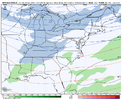
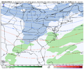
We got one more toasty day suposedly tommorow. Then thats it, assuming this wedge gets out of the way tommorow. Sunday will average AN slightly as we start the transition back to full time winter Sunday night.
 
Today’s Euro Weeklies update:

View attachment 180001
I’m willing to bet by mid Jan we have a +PNA mixed into a +TNH (Hudson bay vortex making an appearance) and we are losing NATL blocking by then. Probably gonna start getting Alaskan ridging in the mix once we retrograde enough. There’s no true MJO signature but there’s still a WWB showing up which could nudge convection further east in the western pacific. This feedbacks to a more favorable state for +TNH (and also another favorability for +PNA if it gets far east enough). If we can get that western US to Alaskan ridge combo, that would be really nice
 
Not that it matters at this point, but the GFS, GEFS,and GEPS still showing some PV stretching around 1/11. We still have the very early SSWE event from November effects working in the background through January. From what I read, we’ve only had a couple examples of that, but the following January was cold with snow and ice events especially mid to late January.


Sent from my iPhone using Tapatalk
 
0a2db86ce2999101bfb593eec108d6e6.jpg


Sent from my iPhone using Tapatalk
 
Latest GFS looked like it wanted to kick something up on the latest 18z around this timeframe, but never really got that connection with the trough and lacked moisture overall. Something to keep an eye on though.
The 12Z GEFS had a couple of members that looked just like the CFS. Low chance at this point, but yes, eyes are on it.
 
Boys and girls how do we have multiple members on the GEFS with a full on winter storm signal across the mid-south for New Years
 

Attachments

  • 89662F6C-BD3E-4F76-9B67-DA6A099ADA65.png
    89662F6C-BD3E-4F76-9B67-DA6A099ADA65.png
    89 KB · Views: 0
  • BB87FF0C-DBD4-4E74-B659-2ACB467FB8B9.png
    BB87FF0C-DBD4-4E74-B659-2ACB467FB8B9.png
    88.4 KB · Views: 0
  • EEEFBB7C-A78B-4815-A1EF-64EDE0418D11.png
    EEEFBB7C-A78B-4815-A1EF-64EDE0418D11.png
    119.2 KB · Views: 0
  • 2D02AC2F-88B3-40D9-9C8E-5F0C1656FBF2.png
    2D02AC2F-88B3-40D9-9C8E-5F0C1656FBF2.png
    121 KB · Views: 0
Boys and girls how do we have multiple members on the GEFS with a full on winter storm signal across the mid-south for New Years
At this moment I would favor west of the mountains/mountains for this possible event. The shortwave is not embedded in an environment to strengthen once it gets closer to the coastal states.
 
This day 8/9 ice threat has legs I think. Been flashing for a while and now all of a sudden we’ve got multiple models honing in on it.
 
Back
Top