The best of both worlds,Pretty crazy how this La Niña is collapsing, straight El Niño vibes on the past few runs
Plenty of cold air to our north (La Nina like) with a stout STJ to our South (EL Nino like).
I'll take it!
Last edited:
The best of both worlds,Pretty crazy how this La Niña is collapsing, straight El Niño vibes on the past few runs
The thing is that the la Nina is cooked at this pointYeah models want to steer toward a La Niña pattern in the long range, but it auto corrects toward a western ridge/east trough ( for the past 2 months) at least.
Sent from my iPhone using Tapatalk
Yes. This is exactly how you get big phasing east coast winter storms. In the middle of a big macro transition. And timed with entire EC hitting peak climo. The timing seems better than good. All you can ask for is a chance. I think this is sort of what Glenn Burns has been hounding on here in the last week. Also the strat stuff. Now, we all just need a little luck. Somebody will get smoked. Why not us?The best of both worlds,
Plenty of cold air to our north (La Nina like) with a stout STJ to our South (EL Nino like).
I
I'll take it!

The thing is that the la Nina is cooked at this point
No offense but tropical tidbits has the absolute worse snow estimates.Gfs trying to give another historic winter storm to the Deep South. Probably never gonna happen but it’s good to see fantasy runs after things looked not so great earlier this month.
View attachment 181607
We all know this.No offense but tropical tidbits has the absolute worse snow estimates.
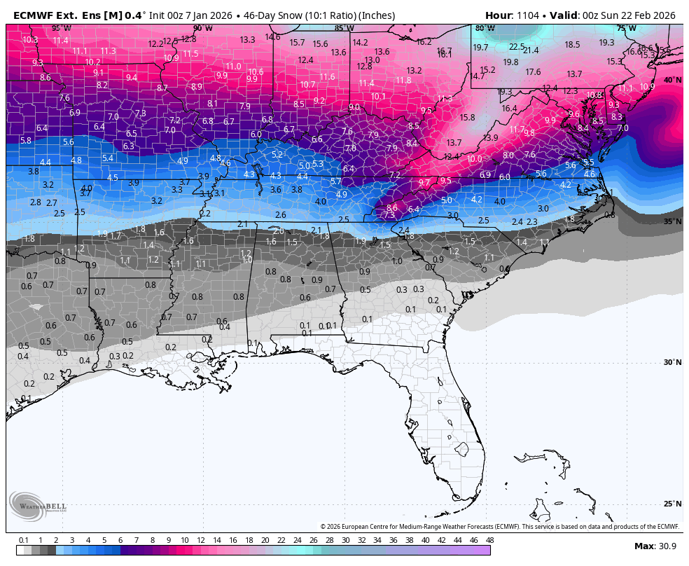
Half of that is zr


.gif")
.gif")
wait didn’t they have us in heat/drought mode for the 8 to 14 range at the start of the week?
Notice near normal precip from the plains to the Midwest and into the NE. They must not be leaning on cutters/apps rubbers for that time period
 suppression favored. Above avg back towards ye ol’ stovepipe. We got a shot
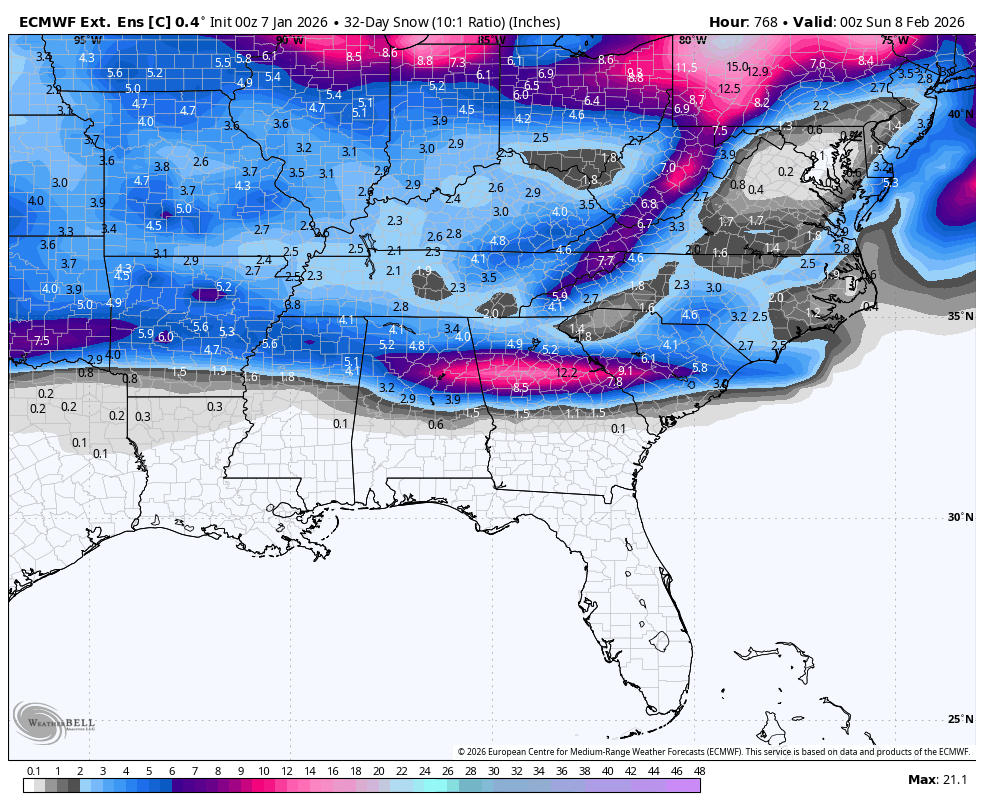


No wonder the weeklies cooked, it actually has a phase 8 MJO in late Jan with subsidence over the maritime continent View attachment 181619
If that’s week 2 of the weeklies, that just about falls in line with the timeframe for the overrunning potential.
Sent from my iPhone using Tapatalk
Man I thought they looked colder. We are so backNo wonder the weeklies cooked, it actually has a phase 8 MJO in late Jan with subsidence over the maritime continent View attachment 181619

The PNA also stayed strongly positive on the control run of the Weeklies.The control looks amazing. Clean phase 8 MJO with the pulse moving into the americas and heavy subsidence over the maritime. Probably why the control has a stupid good pattern to end out jan View attachment 181620


EPS has been headed for a SER for how long now ? Only to correct the anomalies further east View attachment 181625View attachment 181626
I believe very little in the predictive power of any models after about 10 days, including ensembles, maybe towards some trends, but that is all. Even the 7-10 days is highly suspect, especially during a volatile change in the atmosphere coming ( tropics convection, Nina to nino, PNA elevation etc etc).That EPS run gave me pause as to where we are headed. It looks like a very possible scenario which we have seen already recently, namely the cold is bottled up North and cuts us off from the temps needed to give us wintry weather. I realize we are a ways out to make definitive statements, but it does not make me feel good to see it contradict the other modeling, hopefully it will go towards the other models rather than them going towards it.

Yep I was already thinking about making a little mini chase if I can get it to hit on a FridayI am not necessarily big on this look, but I like the slowing down trend regardless for future prospects, might turn out to be a good NW flow snow event as well, Mr highcountry would love that View attachment 181628
This is becoming impossible to ignore at this point with how much it's showing this outcome.Looks like this run sends the energy back into the pacific again as well lol
Brother. Don’t turn into a doubter please. We got plenty of these in here already.This is becoming impossible to ignore at this point with how much it's showing this outcome.
Yeh it this could move to the weekend, I’d book a cabin in GatlinburgYep I was already thinking about making a little mini chase if I can get it to hit on a Friday
Yeh it this could move to the weekend, I’d book a cabin in Gatlinburg

We use Elk Springs & love it! Anyways, sorry for the banter!Already have 10 cabins saved for the wife to review for MLK weekend. Historically been money for snow up there the last 10 years for our family.
We need to run it back like Jan 22’. Except this time you don’t get stuck at the bottom of the driveway lolAlready have 10 cabins saved for the wife to review for MLK weekend. Historically been money for snow up there the last 10 years for our family.
Anywhere of ski mountain road, preferably closer to ober Gatlinburg. It’s wild the difference in the top and the bottom of the mountain. I target 2800-3000 feet in elevation. Never fails me.
Great thing about Gatlinburg is they keep the roads maintained as well.