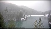
Nice 21 degrees in deer stand this morning. Amazing what it was 24 hours. Still long way to go this winter.
-
Hello, please take a minute to check out our awesome content, contributed by the wonderful members of our community. We hope you'll add your own thoughts and opinions by making a free account!
You are using an out of date browser. It may not display this or other websites correctly.
You should upgrade or use an alternative browser.
You should upgrade or use an alternative browser.
Pattern January Joke
- Thread starter SD
- Start date
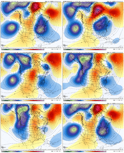
It’s amazing how every model goes poorly every single overnight. Well except for the ICON which held fairly steady within its timeframe.I mean I don't have really any good news this morning. The runs overnight were worse than the runs overnight the night before. It's honestly ridiculous how much they flipped with what the Euro did with the storm signal at the day 9-11 range. Personally, I don't give a rip about that timeframe. It can work out for many on here, but it just screams Mid Atlantic/Southern Apps potential into the Northeast.
What I don't want to lose is the "beyond" timeframe (Mid month into late January). I mentioned yesterday about my concern with the cold dropping to far West. @Brent would be a big fan of this, but 99% of the board would not. You can see small signs at it here & there. The next worry I have is if the cold drops South enough to link up with a waking up Southern Jet. The 00z EPS is not as good as the last couple ones. The GEFS AI probably has the best look & the GEFS is dropping cold West (it hasn't finished running yet). It doesn't mean the cold wouldn't eventually come East if that is the route it took.
The good news is that there is a pretty high signal for a lot of cold air dropping down at the mid to late month timeframe. I mean the signal is very strong for this on all guidance.
But I tell ya, the rug pull overnight on that day 9-11 storm for EVERYBODY is wild. Lol i am betting it returns though.
View attachment 180506View attachment 180502View attachment 180503View attachment 180504View attachment 180505
Is there any logical reason for this? Or just plain bad luck lolIt’s amazing how every model goes poorly every single overnight. Well except for the ICON which held fairly steady within its timeframe.
I'm betting it has to do with the lower # of weather balloons that have been released this year due to this admin's budget cuts. Never seen this much flip flopping of the modelsIs there any logical reason for this? Or just plain bad luck lol
MichaelJ
Member
I really don't expect anything here of a noteworthy nature until after the 15th. What you saw in the overnight runs was how hard of a time a pattern change is for them to catch on to until very late. Now on those awful overnights, you see a progressive pattern being pushed too quickly (IMO) that could go either way still, but if the destruction of the block and trough going into the west is accurate, I don't see how we get anything until late month, (Jan) possibly. Let's see what the 12Z shows in order to see if we have a developing trend, or just models on crack at night.
Feels like every other year honestly. We have a winter storm that’s there for a couple days, morale is up, vibes are good and then *poof*. After that we spend the next several days clawing back into something that’s workable. Except this isn’t a storm we just lost. It’s an entire pattern. We’re gonna need that -EPO I think. Good luck everybody. Still early
packfan98
Moderator
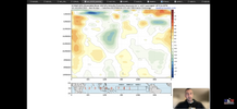
BAM says to CALM DOWN! Great video that lays out the evolution of the pattern.
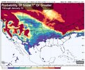
James Spann posted this on X to show that over the next 15 days, the probability of 1" snow in AL was 0%.
I can't figure out why people use these maps this way. The model will run again in a few hours, and it might very show a probability of 30% for 1" of snow in AL. I've seen this a lot.
So if that happens, was the probability of the first run actually 0%?
I don't understand why this tool is any more useful when used over a long period of time than a snow map, particularly when he used it in the way that he did (which is a quite common practice).
What am I missing?

NBAcentel
Member
Tsappfrog20
Member
Allan agrees with you all that it is looking less likely from the 8-10 timeframe window but truly believes that the pattern flips around the 15 and we have a cold and stormy pattern set up
Sent from my iPhone using Tapatalk
Sent from my iPhone using Tapatalk
Yeh that's what I am saying. Call it kicking the can.. Idc, but the mid month to late month timeframe is where it's at. If we kick that can, then yeh.. I don't have any faith in February. That month sucks.Allan agrees with you all that it is looking less likely from the 8-10 timeframe window but truly believes that the pattern flips around the 15 and we have a cold and stormy pattern set up
Sent from my iPhone using Tapatalk
Goodmorning to everybody except this guy..James Spann posted this on X to show that over the next 15 days, the probability of 1" snow in AL was 0%.
I can't figure out why people use these maps this way. The model will run again in a few hours, and it might very show a probability of 30% for 1" of snow in AL. I've seen this a lot.
So if that happens, was the probability of the first run actually 0%?
I don't understand why this tool is any more useful when used over a long period of time than a snow map, particularly when he used it in the way that he did (which is a quite common practice).
What am I missing?
View attachment 180511
Spann probably
SnowNiner
Member
I think the take away for me is, we're 2 weeks out until our good pattern establishes. It's taking that long for the pacific to shake up in our favor. For the next 2 weeks, we've got Greenland ridging that may or may not keep us cool/cold based on whether or not we can wedge with a 50/50 low.
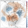
During this time however the pacific is indeed changing as discussed (praises!! lol). Mid January, the below still looks good to me. Trough east of Hawaii, ridging up the west coast into AK, blocking much of the pole, a trough generally in the east, with a split flow. Will that hold, I don't know. Hopefully so, but the fact that the pacific is shaking up at the least is great news to me. And BAM's on our side so there's that (until maybe tomorrow lol).
Next 2 weeks though I think we all just need to wait, as we normally like to do. At least there's light at the end of this AK vortex tunnel.

Brent
Member
Even out here yeah I'm not really convinced about the first timeframe. I think it's gonna be later
The signal for the 9th or whatever has always just been a few members here and there. Not that impressive. It was usually 1 or 2 big ones skewing it with a lot of nothing members
The signal for the 9th or whatever has always just been a few members here and there. Not that impressive. It was usually 1 or 2 big ones skewing it with a lot of nothing members
Good ole JB been saying this for over a week now on his videos. Said nothing until after mid month then should get interesting. We shall seeI really don't expect anything here of a noteworthy nature until after the 15th. What you saw in the overnight runs was how hard of a time a pattern change is for them to catch on to until very late. Now on those awful overnights, you see a progressive pattern being pushed too quickly (IMO) that could go either way still, but if the destruction of the block and trough going into the west is accurate, I don't see how we get anything until late month, (Jan) possibly. Let's see what the 12Z shows in order to see if we have a developing trend, or just models on crack at night.
Drizzle Snizzle
Member
I know there was snow in parts of the south in February 2015 and even early March 2015.Most of the western half of NC hasn't had a major winter storm in February or March since 2014...
NCWeatherNow
Member
It’s amazing how every model goes poorly every single overnight. Well except for the ICON which held fairly steady within its timefram
BAM says to CALM DOWN! Great video that lays out the evolution of the pattern.
Its just one 00z run, we are still nearly 10+ days from any potential storm systems.
It can easily trend back the other way later today even.
Hence the word major winter storm there have been some small events since but very few have seen any snow since 2021 in those monthsI know there was snow in parts of the south in February 2015 and even early March 2015.
Do not take the troll bait. Ignore those post and you'll thank me laterHence the word major winter storm there have been some small events since but very few have seen any snow since 2021 in those months
My 2 cents is that after the change in the pacific shuffle we do see a good pattern. However, like most pattern changes, it is usually not as epic as the pattern portrayed on most of the runs yesterday. Almost every winter, the perfect pattern is displayed repeatedly in the ensembles, but never quite materializes. There is a reason these epic patterns are rare.
Pilotwx
Member
There are a few people on this board that know me personally like Big Frosty and Powerstroke. I’m always trying finding a little bit of hope for snow and I admit I’m a snow fan!
But if we are being honest here I don’t see a single sign we are going to be seeing winter weather other than the mountains. And when models start down the road of showing a warmer pattern and flip flopping it’s 90% of time going to be to the warm side. Hope , I’m wrong and eating crow.
But if we are being honest here I don’t see a single sign we are going to be seeing winter weather other than the mountains. And when models start down the road of showing a warmer pattern and flip flopping it’s 90% of time going to be to the warm side. Hope , I’m wrong and eating crow.
FoothillsWX
Member
Morning thoughts. There is no perfect pattern for us. It never all aligns. Embrace it! Some of the biggest storms have come from the dumbest setups. With that said, the upper level pattern still looks like it’s setting up for a great stretch. Don’t let last night’s model runs distract you from the fact that the models are ASS. They quite literally suck. Every single one of them. Anything past 4 days at this juncture shouldn’t include cliff diving. Heck we were supposed to be golfing right now with an endless torch the likes of which the east coast has never seen but I have a fire rolling and a low near 20.
ducketta27
Member
Most of the western half of NC hasn't had a major winter storm in February or March since 2014...
Agreed. Last time SC saw anything notable as well was in 2014… (besides that extreme east/coastal storm last year - which panned out mostly east of I95).
Sent from my iPhone using Tapatalk
Stormlover
Member
Tsappfrog20
Member
This was Allan’s January thoughts

Sent from my iPhone using Tapatalk

Sent from my iPhone using Tapatalk
CNCsnwfan1210
Member
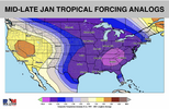
The key is what’s going on in the tropical Pacific, the tropical convection looks to move into the favorable phases by mid January. Eric mentioned about the -EPO and how it will get established later along with the +PNA and some blocking over Greenland. Also, the SPV will continue to be in a disturbed, stretched wobbling state in mid January. The major flip with the SPV forecast, the Euro colder change in the weeklies (that was a big change btw), and what the past analogs are telling us from previous years where we had an early SSWE and the change that happened in December/January, I’m not ready to jump off the cliff. These models have been awful performing here lately. These colder trends in the week 2 periods have been nuts and doesn’t look like that’s going to change imo. So, I’m really optimistic of where we are headed especially by mid-late January.
Sent from my iPhone using Tapatalk
Sent from my iPhone using Tapatalk
NCHighCountryWX
Member
- Joined
- Dec 28, 2016
- Messages
- 699
- Reaction score
- 1,918
Mahomeless
Member
Drastically skewed by 2 members18Z GEFS mean through Jan 11th:
View attachment 180445
SnowNiner
Member
This was Allan’s January thoughts
Sent from my iPhone using Tapatalk
That looks alot like the --WPO/+EPO/+TNH pattern from early December. I hope we get a little better cold trajectory with +PNA ridging mid month into the center of the conus, not just the NE. Maybe that's combination of both halves of the month though.
Mahomeless
Member
He’s subpar when it comes to winter weather.James Spann posted this on X to show that over the next 15 days, the probability of 1" snow in AL was 0%.
I can't figure out why people use these maps this way. The model will run again in a few hours, and it might very show a probability of 30% for 1" of snow in AL. I've seen this a lot.
So if that happens, was the probability of the first run actually 0%?
I don't understand why this tool is any more useful when used over a long period of time than a snow map, particularly when he used it in the way that he did (which is a quite common practice).
What am I missing?
View attachment 180511
wow
Member
How would you like your crow served Sir? I'll send you a plate with some taters and yams by Jan. 31st. lolThere are a few people on this board that know me personally like Big Frosty and Powerstroke. I’m always trying finding a little bit of hope for snow and I admit I’m a snow fan!
But if we are being honest here I don’t see a single sign we are going to be seeing winter weather other than the mountains. And when models start down the road of showing a warmer pattern and flip flopping it’s 90% of time going to be to the warm side. Hope , I’m wrong and eating crow.
BTW- That BAM video is excellent this morning, give it a watch... Cold 23.7 this morning
James Spann posted this on X to show that over the next 15 days, the probability of 1" snow in AL was 0%.
I can't figure out why people use these maps this way. The model will run again in a few hours, and it might very show a probability of 30% for 1" of snow in AL. I've seen this a lot.
So if that happens, was the probability of the first run actually 0%?
I don't understand why this tool is any more useful when used over a long period of time than a snow map, particularly when he used it in the way that he did (which is a quite common practice).
What am I missing?
View attachment 180511
i think mets do this because:
1. the public prefers the specific number (numbers don't lie etc) to vague conditional statements
2. when you say "just a model, NOT a forecast", it shirks accountability off you if the model is wrong while you still have a claim to "being early" if the model is right
3. not very labor intensive. takes 5 minutes to post this
that's really it
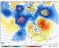
We are going from a hideous aleutian ridge to a workable pac with heights building over the pole...seems like a good spot to be in for back half of a winter.
View attachment 180521
Let's see how the models trend over the next few days for the front side of this pattern with the NAO etc....I was hopeful that could improve, but rough ride overnight.
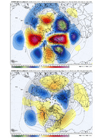
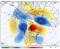
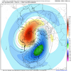
But to your point down the road on the Pacific side, I'll throw in one more element. In between our ongoing and nasty Aleutian ridge pattern and potential developing west coast ridge pattern, we get this period here of low pressure from NE Siberia thru the Bering Sea and into the E Pac (with Greenland block). That's a classic SPV weakening look. When that happens, you'll see an Aleutian high develop in the high stratosphere, leading to SPV stretching (2nd image). Point being - we are 'hoping' to evolve into this -EPO / +PNA type pattern in the troposphere mid-Jan etc, but we may get the added benefit of it being pre-conditioned by this setup which also leads to SPV weakening and stretching which can assist in overall cold delivery down into the troposphere. Also, mid Jan is favorable for longer wavelengths - with broader, wider cold across the conus being the goal.
Thank you. That's along the lines of what I assumed. There's been a big move to probability forecasting, using all of these various ensemble suites and their products. I think there is some value in this over short time frames and even value in longer time frames when it comes to larger scale variables.i think mets do this because:
1. the public prefers the specific number (numbers don't lie etc) to vague conditional statements
2. when you say "just a model, NOT a forecast", it shirks accountability off you if the model is wrong while you still have a claim to "being early" if the model is right
3. not very labor intensive. takes 5 minutes to post this
that's really it
But a 2 week snowfall probability map seems pointless to me, if you're making an actual forecast.
The industry as a whole has become very model-reliant, and leaning too heavily on probability forecasting isn't a lot better IMO, even though it might "sound" better.
Anyway, thank you.
trackersacker
Member
Interesting to note that weathermodels.com (Ryan Maue’s site) has the 10 mb stratospheric ensemble mean from the EPS. The ensembles on Weatherbell don’t have those. You have to look at the control and deterministic runs. I like this.Let's see how the models trend over the next few days for the front side of this pattern with the NAO etc....I was hopeful that could improve, but rough ride overnight.
But to your point down the road on the Pacific side, I'll throw in one more element. In between our ongoing and nasty Aleutian ridge pattern and potential developing west coast ridge pattern, we get this period here of low pressure from NE Siberia thru the Bering Sea and into the E Pac (with Greenland block). That's a classic SPV weakening look. When that happens, you'll see an Aleutian high develop in the high stratosphere, leading to SPV stretching (2nd image). Point being - we are 'hoping' to evolve into this -EPO / +PNA type pattern in the troposphere mid-Jan etc, but we may get the added benefit of it being pre-conditioned by this setup which also leads to SPV weakening and stretching which can assist in overall cold delivery down into the troposphere. Also, mid Jan is favorable for longer wavelengths - with broader, wider cold across the conus being the goal.
View attachment 180524
View attachment 180525
NBAcentel
Member

