-
Hello, please take a minute to check out our awesome content, contributed by the wonderful members of our community. We hope you'll add your own thoughts and opinions by making a free account!
You are using an out of date browser. It may not display this or other websites correctly.
You should upgrade or use an alternative browser.
You should upgrade or use an alternative browser.
Wintry January 8-9 Wintery Weather Potential!
- Thread starter Ollie Williams
- Start date
-
- Tags
- winter

Clem282340
Member
His the ull further south than it was at 12z

NBAcentel
Member


Looks good for most of North Carolina.. wow!!
NBAcentel
Member
Soundings are to close for comfort 
Definitely a trend south...

NorthGaWinter4
Member
Man if i was in Nc I’d be pretty stocked right now. It’s pretty close here too... looking for a bit more southern trend!
NBAcentel
Member

Shaggy
Member
Looks good for most of North Carolina.. wow!!
Wouldnt mind that low maybe 50 miles further offshore here east of I-95 as it moves off. Ill take this run though.
NBAcentel
Member
As you get closer to I/40-77 things cool down aloft a bit more, but imo I could see IP being a issue with this look 


Shaggy
Member
Not too bad for mby
Attachments
NBAcentel
Member
EPS looks better, snow mean shifted SE a bit

NBAcentel
Member

Webberweather53
Meteorologist
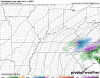
Yep not buying snow with that lookAs you get closer to I/40-77 things cool down aloft a bit more, but imo I could see IP being a issue with this look View attachment 62345View attachment 62346View attachment 62347View attachment 62348
Clem282340
Member
What does the individual members look like for klqk please
Webberweather53
Meteorologist
Tonight’s euro is a southern outlier in the context of its ensemble. Not buying these snow maps on very coarse gridded ensembles given the soundings we are seeing
NBAcentel
Member
GFS has the best solution as it forms a 850 low to our SE, and wraps around cold air aloft the best, if this could happen at night this would be better 

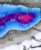
0z GFS paints 7 my County,0Z Euro paints 4.7. Zero wiggle room, Marginal event. Whens it not. Expectations in check. Not counting on,buying it yet.
6z GFS not as cold but still was able to put something down. Confluence looks better, but more WAA this run and keeps trending that way.


Meanwhile the GFSv16 had a pants annihilation run...well at least we can dream


00z GEFS vs 06z GEFS
00z


06z


00z
06z
Being able to track something is better than having nothing to track. But this (possible) event is most likely not going to provide the accumulating snows some of the models are spitting out. I wish it would, but we're having to rely on everything aligning perfectly just to get a wet snow with temps still above freezing. Can it happen --> sure (it's happed before).
I think the best outcome (at this point), is a rain/snow mix changing over to snow as the system moves out. A slushy inch or two would be a huge win (for the lucky few). **but that's just my take at this time.
Here's RAH's discussion:
Thursday night precipitation will overspread the region, with the
low reaching Charleston, SC by Friday morning. Temperatures stay
above freezing Thursday night, and have kept all precipitation rain
during this time. However, a blend of ECMWF and GFS partial
thicknesses does indicate that there could be at least a brief
period of a rain/snow mix across northern counties Friday morning
before temperatures warm enough to change all precipitation over to
rain. The 00Z models came in much colder with daytime highs on
Friday, and decided to cut highs by about 5 degrees which is less
aggressive than the 00Z models would suggest. It now seems unlikely
that the Triad will reach 40 degrees, while the Triangle should be
in the low 40s. The surface low will move offshore by Friday
evening, with wraparound precipitation continuing into Friday night.
The models have continued their trend from the 12Z guidance in
moving precipitation out to sea quicker than they did 24 hours, but
think that there will be a slight chance for snow to mix in with
rain east of Raleigh as precipitation comes to an end after midnight.
Nail the track. If your Back yard is lucky, gets the right track. Then go to thermals starting Wednesday,Thurs (48 hrs on in). All these clowns are 10:1 ratio. When viewing next few days outside mtns I'd use a max of 5:1, so slice in half. That's best case scenerio. This probably will end up being a trash can lid topper I40 north. Mtns, espeacilly northern Mtns look solid for a potential 6+incher. But for Triad right now the track is everything and only concern. If it pans out like its modeled currently. Then we can take the long shot and hopefully navigate the thermals hurdle. Which will be a huge battle within itself. But it's all moot with a track underneath us.
6z GFS


6z GFSv: LOL

6z GFS
6z GFSv: LOL
Last edited:
Last Night 0z :
Ukie little more wound up futher south track than Euro:


0z Euro:

Rides up over Charlotte, opens up some, Then tightens back down exits New Bern:

6z GFS


6z New GFS

Ukie little more wound up futher south track than Euro:
0z Euro:
Rides up over Charlotte, opens up some, Then tightens back down exits New Bern:
6z GFS
6z New GFS
So since we're tracking this event, it would be nice to get our soil temps down a little more the next few days. Looking at the grid forecast leading up to this event, it looks like central NC will have highs in the upper 40s / low 50s and lows in the upper 20s / low 30s. Not sure how much that can help the current readings.
Soil temps:

Soil temps:
Webberweather53
Meteorologist
Usually not a good sign when the gfs shows a ton of warm advection.6z GFS not as cold but still was able to put something down. Confluence looks better, but more WAA this run and keeps trending that way.View attachment 62381View attachment 62382
View attachment 62383View attachment 62384
iGRXY
Member
The trends through this morning look like a ULL track that is more south and tracking through the I20 corridor which absolutely helps those northwestern sections. Biggest thing to watch is the warm nose as well and how stout it’s going to be. The models have trended colder aloft except for the 6z GFS that had more WAA but the newer version did not. I will say the current track of this ULL has always produced the best chance at accumulating snowfall in my neck of the woods so hopefully that will continue here.
- Joined
- Jan 2, 2017
- Messages
- 1,568
- Reaction score
- 4,283
------ Webb I was almost sucked in until I read this..gee thx..No really thank youTonight’s euro is a southern outlier in the context of its ensemble. Not buying these snow maps on very coarse gridded ensembles given the soundings we are seeing
Blue_Ridge_Escarpment
Member
Word of caution. We are getting into the window where the euro sometimes loses the storm or plays tricks. Don’t panic.
Does anyone have the 06z EPS? I have p-type charts but they aren't wroth a crap.


Wouldnt mind that low maybe 50 miles further offshore here east of I-95 as it moves off. Ill take this run though.
I’d take 100-125 offshor
iGRXY
Member


Clem282340
Member
What was the mean
iGRXY
Member
6ZWhat was the mean

0Z

Basically stayed the same through our area.
Looks like the 00z Euro is all in on the backside deformation banding for the RDU east area. Anything that fell before 00z was rain. It's going to be an extremely narrow, tight rope to walk but it isn't impossible. A slushy inch or two can't be ruled out if a strong band develops on the backside of the system as CAA kicks in and the timing is after 00z.


Jessy89
Member
The way I’m feeling about this in upstate South Carolina north of I85. Temps will be marginal I could see it turning to snow early in the morning on Friday. Accumulation that’s gonna be hard maybe a Dusting to 1 inch especially as you head up to the extreme northern parts of oconee Pickens Greenville county. Doesn’t look like a big storm for the upstate. But a good Dusting would be a win. However snow at all is still a small chance for now
Sent from my iPhone using Tapatalk
Sent from my iPhone using Tapatalk
That looks like a December ‘18 map, only lighter for Upstate!