SimeonNC
Member
Decided to pull the trigger and make the thread, mods feel free to lock it if you feel like it's too soon.
Perfect! The family is ready for a 6 hour trip to Banner Elk, just need the NC experts to chime in on whether that's a good choice or not.Decided to pull the trigger and make the thread, mods feel free to lock it if you feel like it's too soon.
They may end up seeing more sleet than snow or ZR if things trend cold enough, the RGEM gives the northern mountains sleet.Perfect! The family is ready for a 6 hour trip to Banner Elk, just need the NC experts to chime in on whether that's a good choice or not.
I figured Boone to Beech would be the only chance for flakes.They may end up seeing more sleet than snow or ZR if things trend cold enough, the RGEM gives the northern mountains sleet.


This may go the other way but if the GFS is already deepening the CAD push….Icon has a couple hours of ZR here
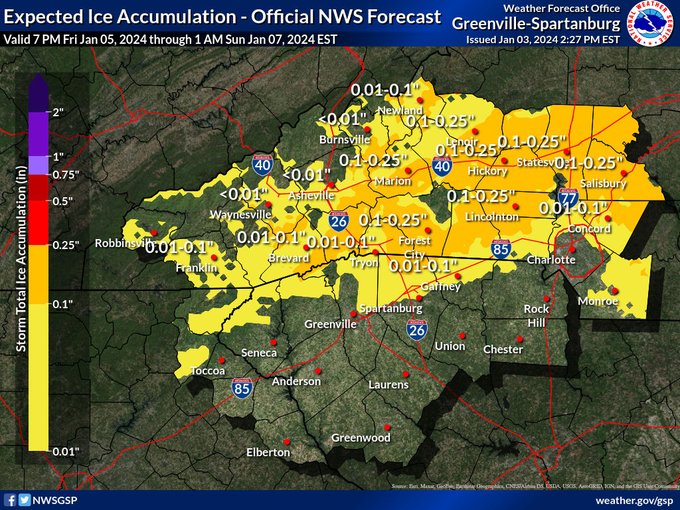
View attachment 139856View attachment 139857
the GFS for the first time brings freezing rain down to northern Charlotte metro View attachment 139855
Could there be any severe weather along the gulf coast?Icon has a couple hours of ZR here
View attachment 139856View attachment 139857
the GFS for the first time brings freezing rain down to northern Charlotte metro View attachment 139855
I figured Boone to Beech would be the only chance for flakes.
.png")
Yes sirCould there be any severe weather along the gulf coast?

First chance at something other than rain or frost accumulating in 2 years. Im with youHeck the RGEM gives me 2hrs of light zr Sat morning, let's go! Lol Of course it will be a decent memory after 3" of rain falls but whatever
Not sure I'd call it an Apps cutter, gets shunted east pretty quick and may not be done adjusting. When it comes to CAD, as bad as the NAM can certainly be, it along with other hi-res models will have a much better handle on boundary layer temps/icing potential. Never under estimate the power of CADEURO is hell bent on an Apps cutter still before transferring to the Peedee region of SC.
How much does what happens tonight affect Saturday and what happens Saturday affect Tuesday? Especially in the borderline areas and Charlotte, Atlanta metros.
Ok first to qualify" I am not a Met, but have some 50 years of tracking weather here in Metro ATL. The system today/tonight will have minimal impact on the system for the 6th -7th. What that will be "riding on" That will be determined by the depth/strength of the CAD/Wedge for this area. A variation of just a 100 or so miles in the placement of the Mid Atlantic High (or it being stronger than progged) or a northward shift in the track of the Low by a little as 50 miles can change mid 30s and rain to 30 and ZR. This will not be a 'ground type" ZR event as ground temps will remain above freezing. It could be a significant "tree/power line" ZR Event as I have seen in the past (Jan 1973)How much does what happens tonight affect Saturday and what happens Saturday affect Tuesday? Especially in the borderline areas and Charlotte, Atlanta metros.

Oh I definitely don't think it's right. I doubt the LP makes above Macon, Georgia at best before it rides around the CAD dome. Problem is you can't trust the surface depiction because it allows warm surface level temps to be further north than reality.Not sure I'd call it an Apps cutter, gets shunted east pretty quick and may not be done adjusting. When it comes to CAD, as bad as the NAM can certainly be, it along with other hi-res models will have a much better handle on boundary layer temps/icing potential. Never under estimate the power of CAD
Never fails. Were trending towards more sleet in the foothills. I hope the trends continue.Seems like both the GFS and NAM are trying to sneak in a burst of snow for the mountains on the front end of this storm.
The safe bet is to always assume the wedge is going to hold on longer than forecast. We’ve seen too many times over the yearsNAM rapidly scours the wedge b/c it has Southeast winds at 925mb... RGEM has a stiff winds out of the Northeast at 925mb along the escarpment for the duration of the storm.
I'd be shocked if the NAM is right with its depiction.
It’s dipping further south ever so slightly every run
Seeing ZR so far east is concerning


Seems like a cold outlier though wrt to dewpoints
3K looks nothing like the NAM. The NAM looks to be eroding the CAD way too fast at the surface and we know how that usually plays out.


I trust the 3K with the dews vs globals and even its counterpart. That's kind of what the 3K should be best at sniffing out due to it's increased resolution.Seems like a cold outlier though wrt to dewpoints View attachment 139918View attachment 139919View attachment 139920View attachment 139921
Another difference the 3k has the LP in the gulf, 12k has it in south BamaI trust the 3K with the dews vs globals and even its counterpart. That's kind of what the 3K should be best at sniffing out due to it's increased resolution.