Blue_Ridge_Escarpment
Member
Looks like the 18Z euro came in a touch colder.
This is from GSPYeah I've noticed that the models are really quick to erode the CAD, even the RGEM.
Also, you know more than me but I feel like the HP in Canada makes this more of a hybrid thab in-situ
ThanksThis is from GSP
Meanwhile, the remnant high
pressure to the east sets up an in-situ wedge of colder air ahead of
the precip. How much cold air remains in place at the onset of
precip is not entirely certain, but should be enough to allow for
near freezing temps well before daybreak.
Im not a good teacher but here's a rundown. In-Situ CAD setup is one in which little or no cold air advection is occurring because the high pressure center which we relied on in the classic setup is too far to the south. Cold air is established through evaporational cooling caused by a pool of dry air east of the Appalachians.
It’ll catch up about 7 hours out
Most of the metro will probably see a trace to a quick glaze on elevated surfaces when initial wetbulbing happens then in a hour or so probably already be over with3K has weird pockets of ZR randomly in Mecklenburg and Union county.

Dews will only tell part of the story, You have to look at wet-bulbs if you want a true comparison.The changes on the dewpoints on the 3km is laughable. I knew a day ago, it was out to lunch and to dry. Mid 20s isn’t cutting it for more then a glaze at best View attachment 139997View attachment 139998
Dews is a part of the formula for sfc wet bulb temps….Dews will only tell part of the story, You have to look at wet-bulbs if you want a true comparison.
I'm going to pay very close attention to not only where DPs bottom out during the evening but also do they rise as fast as the NAM is showing as precip approaches. If in reality we are sitting in the mid to upper teens for dews that evening vs the low 20's and generally hold to the low 20's as precip arrives, I think there's a solid chance at some icing. Also paying attention to where the temps are sitting around 10pm. Are we sitting around 33-35 with Dews in the low 20's or are we sitting in th mid to upper 30's range? Noway to know until tomorrow night.Dews will only tell part of the story, You have to look at wet-bulbs if you want a true comparison.


22.1 here this morning with mega frost, even some frosty tree tops around creeks and swampy areas. I don't have a dog in this potential storm fight, but, I'll be shocked if temps aren't a touch cooler tonight than model forecast and precip doesn't arrive a tick sooner (almost always does) giving a glancing blow to at least western triangle counties.19.8/17 here this morning..... wasn't expecting it to get that low last night. That will certainly drop those soil temps. It may also play a part in how long we keep the sub-freezing temps tomorrow.
Yeah, I think eventually they may have to add Orange and Durham(mostly for NW Durham) to the advisory.22.1 here this morning with mega frost, even some frosty tree tops around creeks and swampy areas. I don't have a dog in this potential storm fight, but, I'll be shocked if temps aren't a touch cooler tonight than model forecast and precip doesn't arrive a tick sooner (almost always does) giving a glancing blow to at least western triangle counties.
I'd agree with that, especially between 85 and 158. North of 158 may hang on for a bit longer.Canadians are adjusting to reality I see. Still think NW Durham and NW Granville (just to name a couple of spots locally) still start as a very brief zr before flipping fast but this is escarpment's baby.
These models suck for these marginal events. Often way to cold time and time again. Decent during deep cold CAD events though. But kinda figured there were out to lunch, hence why I didn’t share the RGEMCanadians are adjusting to reality I see. Still think NW Durham and NW Granville (just to name a couple of spots locally) still start as a very brief zr before flipping fast but this is escarpment's baby.
View attachment 140035

highly doubt any ZR makes it into Spartanburg county other then the extreme far northern fringes, even the colder models like the nam don’t show ZR down there anymoreView attachment 140068
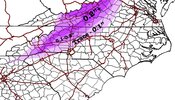
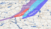
Updated map. I'm expecting around a tenth of inch or less in mby. The sweet spot is still going to be from Brevard to Hendersonville, Saluda, and Chimney Rock. The far western foothills and closest to the escarpment get 0.25"+. Further east drops off considerably. 85 corridor probably gets a trace to maybe 5 hundredths of an inch at most.
we have the fire going ready for the cold rain!Homerun. Snow meter high here. Standby View attachment 140120
