• Hello, please take a minute to check out our awesome content, contributed by the wonderful members of our community. We hope you'll add your own thoughts and opinions by making a free account!

Wintry January 23rd-27th 2026

Sleet and 19 degrees. The radar is interesting for central NC. It looks like we keep getting a feed of moisture directly from the south while we get the main precip bands from the SW. It also looks like we keep building precip bands down into SC as they move Northeastward.


A lot of posters mentioned this could happen. That the moisture would continue back building and filling in. I wonder if all those storms in the gulf continues to feed moisture upstream. No professional at all. Just curious


Sent from my iPhone using Tapatalk
 
Honestly confused. All the weather stations on the ground near me on wundermap show 30°or 29°. But there is a bunch of liquid water on the ground and I’m seeing icicles melt, and precip we are getting isn’t freezing. Not sure what the deal is.
Same here. I asked my good friend Chad G.P. Tee about this and here’s what he sent me:

Why rain can occur in wedge areas with surface temps in the upper 20s
- Warm advection aloft with a shallow cold layer near the surface: The surface is cold (upper 20s °F), but the air above the shallow boundary layer is warmer. If the temperature profile is: surface near or just below freezing, a rapid warm layer a few hundred to a couple thousand feet thick above, and then cooler air aloft, precipitation can fall as rain through the warm layer and remain rain at the surface if the surface layer is not too cold or if the cold air is shallow enough that rain doesn’t have time to cool and freeze on contact.
- Temperature profile above the surface determines precipitation type: If the layer of subfreezing air at the surface is thin and the temperature just above the surface is above freezing, raindrops can reach the surface as rain or as drizzle. If the cold layer is shallow enough and the surface temperature is just below freezing, you may still get rain if the raindrops don’t have enough time to warm and refreeze (or if the surface warms slightly with solar input or ground warming).
- Boundary layer mixing and heating: Surface winds and mixing can bring slightly warmer air to the lowest few hundred feet, lifting the surface temperature a degree or two above freezing during precipitation. If the surface is in the upper 20s but warms to near 32°F at the very surface due to radiative cooling constraints breaking during daytime or due to frictional heating, rain can reach the ground.
- Ground temperature and melting layer: Rain can survive as rain if the cold surface layer is not deep enough to freeze the falling droplets before they reach the ground, especially if the ground itself is not cold enough to induce rapid freezing of water on contact.
- Temporal evolution: In a wedge, the temperature profile can evolve during the event. Initially there may be freezing rain or sleet, but as warm air advection persists at mid-levels, the low-level temperature can rise or the warm layer can thicken, producing rain even if surface temps stay in the upper 20s.
 
Do we think we stay below freezing for that line? I just don't see how we can with all of that convection. It has to be pulling up some super warm air.
Highly doubt we go above freezing. Never bet against the wedge. Hrrr is in the low 20s for that line and is currently doing the best, and it still Slightly to warm obs wise.
IMG_3296.pngIMG_3295.png
 
Do we think we stay below freezing for that line? I just don't see how we can with all of that convection. It has to be pulling up some super warm air.
The thing is we’re in the upper teens right now. That’s a long way to warm up above freezing
 
19005886021302e0486e375b47e60f56.gif

Current NWS Raleigh radar


Sent from my iPhone using Tapatalk
 
hrrr now showing the center of the low going through south/south central ga. 3km nam is even further south. As many have noted before, lows can not steam through a wedge..especially one this strong. They have to go around. This keeps the winds back NE, and the wedge locked in place. Gfs is going bust by 5 or 6 degrees in the heart of the wedge by late this afternoon. Euro by 10 to 15 degrees, uk by 4 or 5. I've been dissapointed with the nam for a couple of days now as it's been consistently too warm. Normally it does a better job but not this time.

temp on my elevated station now down to 23.9, 24.7 on my 2 meter. I imagine this is the low point since temps are the same in greenwood and even gone up a degree or 2.

11hrrr.png
 
screenshot-1769354959589.png
The HRRR has lowered ice accrual totals again with its latest run. With these amounts, under normal circumstances, I would think chances are good that power outages would be limited. However, the winds from this event will add an additional element to the equation that tells me we are not out of the woods yet.
 
View attachment 189008
The HRRR has lowered ice accrual totals again with its latest run. With these amounts, under normal circumstances, I would think chances are good that power outages would be limited. However, the winds from this event will add an additional element to the equation that tell me that we are not out of the woods yet.
Does this include sleet? I would think some of this falls as sleet or rain with how much convection it is.
 
hrrr now showing the center of the low going through south/south central ga. 3km nam is even further south. As many have noted before, lows can not steam through a wedge..especially one this strong. They have to go around. This keeps the winds back NE, and the wedge locked in place. Gfs is going bust by 5 or 6 degrees in the heart of the wedge by late this afternoon. Euro by 10 to 15 degrees, uk by 4 or 5. I've been dissapointed with the nam for a couple of days now as it's been consistently too warm. Normally it does a better job but not this time.

temp on my elevated station now down to 23.9, 24.7 on my 2 meter. I imagine this is the low point since temps are the same in greenwood and even gone up a degree or 2.

View attachment 189010
Dropped here as well; down to 26.7 from 27.4 an hour ago
 
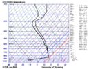
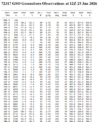
So here is the actual sounding from Greensboro (GSO) at 12z (7AM) this morning. Pretty insane. I drew in the blue line for 0 deg C and red line for 10 deg C. Text output for the sounding is below that. Max temp in the warm nose is +9 deg C at 850mb. The surface up to 925mb is below -10 deg C. Also notice on the text output that in the cold layer up to 925mb, the relative humidity is in the range of 81% to 92%. Saturation with respect to water is 100%, but my understanding is that saturation with respect to ice is 80%, though I believe there is a chart where this varies based on pressure.

So, as has been discussed some in here, the snowflake is completely melting as it falls thru the 9 deg C warm nose. A snowflake that completely melts into a water drop no longer has ice nuclei where it can refreeze as it falls before it hits the ground. However, the low levels below 925mb are cold enough (below 10 deg C) and moist enough (above 80% relative humidity) where ice nuclei are present (low level dendrite growth zone), and the water drop picks up that ice nuclei, and can then either refreeze as snow or sleet. Presumably the longer the drop stays in this cold layer, the better chance it has to turn back in to a rimed snowflake vs. a sleet pellet (my presumption)


Jan 25 GSO Sounding.png

Jan 25 GSO Text.png
 
Question, my wind direction for ATL airport went from the E to now SE. What does that mean?
would assume it means the wedge and the competing forces are going head to head.. same was seeing wsw winds then back to northeast we briefly dropped to 26 back to 27.. idk what im reading with ppl wondering why its melting on the ground ..ground temps are above freezing atm.. and for the ppl asking why they see rain and water dripping off the ice when its below freezing.. i assume the liquid is falling faster than it can freeze
 
If this wedge holds temps below freezing in Athens ga for the remainder of the afternoon precip. How much additional ice are we looking at here. Looks awfully close.
 
would assume it means the wedge and the competing forces are going head to head.. same was seeing wsw winds then back to northeast we briefly dropped to 26 back to 27.. idk what im reading with ppl wondering why its melting on the ground ..ground temps are above freezing atm.. and for the ppl asking why they see rain and water dripping off the ice when its below freezing.. i assume the liquid is falling faster than it can freeze
UV will also induce minimal melting at borderline temps, even with clouds.
 
They have the forecast here for now at 32 degrees for a high, saying the wedge front will stay in the southern midlands, we are always on the edge and its hard to predict, but all meso models have all fzr with rain on the very back end, its a wait in see in our area.

My location here in Lexington continues to fluctuate from 24 to 25 with light dandruff falling.


Sent from my iPhone using Tapatalk
 
would assume it means the wedge and the competing forces are going head to head.. same was seeing wsw winds then back to northeast we briefly dropped to 26 back to 27.. idk what im reading with ppl wondering why its melting on the ground ..ground temps are above freezing atm.. and for the ppl asking why they see rain and water dripping off the ice when its below freezing.. i assume the liquid is falling faster than it can freeze
I guess i just dont understand how the temp is 28 here and the rain is falling on ice/sleet and puddling? I would assume at 28 rain falling would on top of ice would freeze but we have more like slush currently
 
My location here in Lexington continues to fluctuate from 24 to 25 with light dandruff falling.


Sent from my iPhone using Tapatalk
IMO they pulled the oh crap putting the high at 32, which says enough in itself as models cant handle CAD at all in the south, just be prepared for the worst and hope for the best as modeling is worthless atm, like most times predicting weather lol
 
RAH is sticking with going above freezing around 10pm tonight in the Triangle and surrounding areas. Be interesting to see if that gets updated and they hold serve. I'm pretty skeptical myself since surface temps are stubbornly holding, but I don't get paid to do this and really just a gut thing based on past experiences. We'll see.
 
RAH is sticking with going above freezing around 10pm tonight in the Triangle and surrounding areas. Be interesting to see if that gets updated and they hold serve. I'm pretty skeptical myself since surface temps are stubbornly holding, but I don't get paid to do this and really just a gut thing based on past experiences. We'll see.
Looking at the short-term models, it'll be close (like 32 or 33 degrees). We'll be in the static airmass waiting for the arctic front to pass tomorrow.
 
Back
Top