• Hello, please take a minute to check out our awesome content, contributed by the wonderful members of our community. We hope you'll add your own thoughts and opinions by making a free account!

Wintry January 23rd-27th 2026

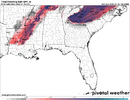
I need my area (ATL airport} to warm up before this squall line.
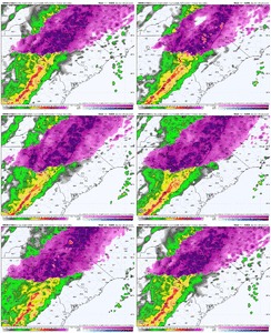
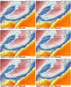
I know there isn't a chance for that happening here. In fact, I probably stay in the 20s... Indeed the hrrr has it staying 30 here through the duration...which to me says....28 or 29. Likewise i don't expect the ne burbs of atlanta to get above freezing either. The precip rates will help limit severe accretion but that's low enough to allow a pretty quick build up. Part of the reason the hrrr is doing this is because it's starting to shift the surface low track south a tick as it suddenly realizes the low will have to go around the stout wedge in place.
 
HRRR and RRFS has me to you and everyone in between below freezing for the duration. Including the "squall" line. Seeing how stout this CAD is, I tend to believe we stay below freezing
Yea, I'm holding steady at 20 degrees still. I just don't see us getting above freezing at all.

Forecasted low last night: 22. Actual: 18. I'm sure I wasn't alone.
 
Beautiful snow and sleep in North Raleigh and it is coming down really good
b74221dda41d09efe520fbc3b799f34c.jpg


Sent from my iPhone using Tapatalk
 
Btw, can we once and for all make it be known the euro is NOT to be taken seriously with regards to cad and temps? Right now it's 4 degrees colder than it showed for my local and Every run, including the 0z run, shows ALL of northeast ga warming above freezing by 1pm. Obviously that's not going to come close to happening. It's been frustrating seeing so many site it and giving it credibility. It's a great medium range model but it sucks with cad.
 
In most winter storms the precipitation steadily builds up as time goes by. This one is a different animal with that squall line coming in later today. The CAD holding on has been a blessing allowing sleet to be the predominant type for many of us thus far. With the heavy rates to come it will be harder for the freezing rain from the squall line to accrue but the high winds might cause more damage than something like that would under normal circumstances.
 
Honestly confused. All the weather stations on the ground near me on wundermap show 30°or 29°. But there is a bunch of liquid water on the ground and I’m seeing icicles melt, and precip we are getting isn’t freezing. Not sure what the deal is.
 
Sleet and 19 degrees. The radar is interesting for central NC. It looks like we keep getting a feed of moisture directly from the south while we get the main precip bands from the SW. It also looks like we keep building precip bands down into SC as they move Northeastward.

 
@GaWx /anyone is there any historical data for a similar set-up for this squall line? We've already proven that this weather is extraordinarily unique. ie: warm nose so stout, and yet the last few meters are cold enough to create sleet or pixie snow.
 
Honestly confused. All the weather stations on the ground near me on wundermap show 30°or 29°. But there is a bunch of liquid water on the ground and I’m seeing icicles melt, and precip we are getting isn’t freezing. Not sure what the deal is.
Its been doingthis same thing here in Ne GA the whole time and we have been in the 25-28 range the whole time. Totally perplexing to me. Im sure one of the really smart people on here can explain
 
Do we think we stay below freezing for that line? I just don't see how we can with all of that convection. It has to be pulling up some super warm air.
 
Back
Top