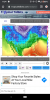
Why that flow supports due E
Sent from my SM-G975U using Tapatalk
I just don’t see how goofy up above doesn’t cause a problem there.
Why that flow supports due E
Sent from my SM-G975U using Tapatalk
Folks, the models are firing warning shots. The only thing we can say today is that there will be a favorable period for a winter storm before the end of the month. Still a lot of things to be sorted out, but I like seeing fantasy storms showing up. I counted 14/20 GFS ensembles giving mby some sort of winter weather before the 31st. Far cry from the pattern we are in right now.
What a pattern if the euro control run is right...storm after storm after storm just dropping down and rolling across..
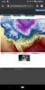
Need that to move about 100 miles north lolCheck out the snow showers in the gulf lol

Do you think we will hit the snowfall average?
I think this first storm will show us that we can’t count on the northwest trend that much the rest of winter or we should be cautious about assuming we get a north west trend ...Check out the snow showers in the gulf lol
I think this first storm will show us that we can’t count on the northwest trend that much the rest of winter or we should be cautious about assuming we get a north west trend ...
In other terms this image shows how cold it’s really about to get which will definitely get everyone back in the wInter shock mood .. this cold air doesn’t like moving so it gives more credibility to the potential CAD event with the storm after it ... we nail that CAD event we can bet positive trends will continue for the board wide storm thereafter


So this is a thing again
Sent from my SM-G975U using Tapatalk
Not a lot left to saturate on this soundingYep big changes over the SE at 126 so close...

Reminds me of the storm down here in Charlotte in January 2018. Overperformed and came out of a similar wave like that.Yep big changes over the SE at 126 so close...
It's another off the wall solution at 500. No matter what it's probably way off.I have a feeling this is going to be a depressing run lol
Looks like it takes too long to eject. Like it knows to wait for cold air to leave before it over runs the Apps.I have a feeling this is going to be a depressing run lol


Not a lot left to saturate on this sounding
Sent from my SM-G975U using Tapatalk
Oh no.SE RIDGE FORMING.
I’ve also been watching this and brought it up a day or so ago .. some Gefs members are more amped with the clipper system shooting down and its able to squeeze out some good snow showers (on some ensemble members) this looks like a flizzard but I’ll take it if it’s a precursor to bigger and better thingWell... it’s something.View attachment 31111View attachment 31112
Looks like this wave is still up near the pole and has an interaction with some other waves in about 72 hours. Maybe we can find a way to get it stronger and westYeah not much to work with, though sometimes it doesn't take a lot.....I have seen similar setups that pay off especially down here if there can be any kind of surface low formation offshore.....need it to dig a bit more and go negative or at least full neutral....
SE RIDGE FORMING.
Hmmm worried about day 10 temp map....??Oh no.
It's a 12 hour warm up ahead of a front. It's ok it happensOh no.

Relax we get to 60 ONE day ... leas than a transient warm shot .. no problems hereOh no.
Warm ground temps before our snowstorm in late JanRelax we get to 60 ONE day ... more than a transient warm shot .. no problems here


Probably not it’s only one day and the temps behind the front are way cold enough to bring any type of small ground warm up from continuing ... plus in January we know ground temps are no problem to overcome After 30 minutes of heavy snowWarm ground temps before our snowstorm in late Jan

Big hit to the upper se this run it appears once more!