Saw HMs tweet about the AAM, that'll be helpful over the next month.
Sent from my SM-G975U using Tapatalk
Sent from my SM-G975U using Tapatalk
Not Much left to beat back:Sounds like one every 3 days. That's gonna get this drought beaten back quite considerably!


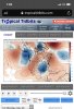
Much better look....maybe less of a kicker? Not sure I like our friend the Lakes Low showing up instead of a cold High Pressure, but let's see what happens.Don't care how this run ends but that is a huge improvement since 12z yesterday on the Euro... look at the pac ridge, 12z yesterday and then 12z today
View attachment 29290
Today
View attachment 29291
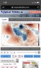
Nothing happened lol but it was close to closing off... big changes from yesterday and I'm sure those changes aren't over.Much better look....maybe less of a kicker? Not sure I like our friend the Lakes Low showing up instead of a cold High Pressure, but let's see what happens.


I hope you're right about the end of January. I originally thought week 3 would start the transition to better, although that is likely going to prove to be a false start. I've been thinking the end of the month as well as the month of Feb would be when we'd have a few periods for durability of a favorable winter pattern. Nothing magical about that...just watching model trends, incorporating seasonality, and counting on earlier bouts of blocking as hints of what may lie ahead later in winter, along with an active STJ.
I actually think our odds of a significant winter event (or more than one) go above average later on.
.png")


Meh, plenty of cold air and while it was a tad slower, it's still very progressive.... I think we either need it to close off or dig enough go negative tilt and pop a coastal late bloomer. Anyway a reprieve from the 70's for a few hoursMuch better look....maybe less of a kicker? Not sure I like our friend the Lakes Low showing up instead of a cold High Pressure, but let's see what happens.

Hoping the eps shows that step in the right direction as well...for that weak wave to produce snow across parts of the SE, you want it slower and stronger initially so it could have a better shot at even going nuetral/negative tilt or just a strong enough trough for decent forcing for Convective snow, and GFS is doing exactly that, the energy you want to look at is north of Montana in Canada, that little cutoff, and the shorter term it’s been slowing down, and has became a little bit amped on the GFS, altho euro is not close, it took a step towards that View attachment 29294
Plus that feature is only about 90 hrs out so could have a better handle on that next 24-48 hrsfor that weak wave to produce snow across parts of the SE, you want it slower and stronger initially so it could have a better shot at even going nuetral/negative tilt or just a strong enough trough for decent forcing for Convective snow, and GFS is doing exactly that, the energy you want to look at is north of Montana in Canada, that little cutoff, and the shorter term it’s been slowing down, and has became a little bit amped on the GFS, altho euro is not close, it took a step towards that View attachment 29294
Hoping the eps shows that step in the right direction as well...


Yeah the Euro sure is consistent....... *sarcasm* Lol
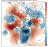
Yesterday's run valid 12z Jan 5th
View attachment 29293
Today's same timestamp
View attachment 29295
Ugh, BAMwx is so bipolar...
Ugh, BAMwx is so bipolar...


Ummm...


Sent from my iPhone using Tapatalk
When the EPS has shown blank signals so far this year while other guidance shows sum, it’s definitely a red flag and makes you think, another “storm” another L like that bowling ball ULL we just had, sure is a bummer but that’s more realistic
This is also the first EPS run that didn't show much of anything, I'd wait for at least a few more model cycles before trying to throw in the towel.
.png")
Few things are more discouraging by day 10 & beyond than seeing a strong, suppressed ridge in the NE Pacific unless of course you like big ridges over the SE US. I'm thankful we at least have a legitimate subtropical jet this winter or we would be in a bigger hole during the expected warm period ~Jan 10-24th.
View attachment 29305
Preach on bro give me another January 99 anytimeBring on the hslc setups, only limiting factor is that instability is at its lowest point during this time, but shear often keeps things going
12Z EPS: cold 1/8-9 followed by pure torch 1/11-14 with temps 10+ warmer than normal (normals for mid-March or later) in most of E US from @SoutheastRidge to @metwannabe to @pcbjr to @Storm5 and folks in between. Who doesn't have pure torch? @Brent because he's far enough away to not be as much AN. He's a very lucky guy!


They say a picture is worth a thousand words.


Sent from my iPhone using Tapatalk
12Z EPS: cold 1/8-9 followed by pure torch 1/11-14 with temps 10+ warmer than normal (normals for mid-March or later) in most of E US from @SoutheastRidge to @metwannabe to @pcbjr to @Storm5 and folks in between. Who doesn't have pure torch? @Brent because he's far enough away to not be as much AN. He's a very lucky guy! Maybe we should move to DFW?
12Z EPS: cold 1/8-9 followed by pure torch 1/11-14 with temps 10+ warmer than normal (normals for mid-March or later) in most of E US from @SoutheastRidge to @metwannabe to @pcbjr to @Storm5 and folks in between. Who doesn't have pure torch? @Brent because he's far enough away to not be as much AN. He's a very lucky guy! Maybe we should move to DFW?

How often does the Deep South get snow period? Obviously if a model starts to show some snow potential then it is worth paying attention to. Especially now as we approach our best time period for possible snow storms.Yeah how often does the deep south get a snow that is modeled 7+ days out. Not very often.
I know it's the CFS, but the 12z run also has it:Fwiw EPS still has a storm signal for the 7-8th