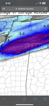
• Hello, please take a minute to check out our awesome content, contributed by the wonderful members of our community. We hope you'll add your own thoughts and opinions by making a free account!

Wintry January 14-16th storm potential.

Yea, I don't think the RAP is sophisticated enough to realize downsloping is going to kill gpf down here in the valley. I hope I am wrong and we get a few inches but not excited about things as they are right this second.
Well, now that HRRR has continued to trend south overnight, it seems to look better east of the mountains. Will check on NAMs and RGEM after church. ?
 
For me, just outside the edge. Rooting for our other peeps … looks like a cool storm for many.

On the FFC forecast discussion below I think where you see NE should be NW. (Not meant to sound like a criticism … The FFC folks do a great job!)

FXUS62 KFFC 141136
AFDFFC

Area Forecast Discussion
National Weather Service Peachtree City GA
636 AM EST Sun Jan 14 2024


...New 12Z Aviation Discussion...

.SHORT TERM...
(Today through Monday)
Issued at 425 AM EST Sun Jan 14 2024

The important parts:

-Dry and pleasant today!

-Winter Weather is set to push into the are on Monday night and into
Tuesday. A Winter Storm Warning has been issued for NE GA with a
Winter Weather Advisory for the remainder of N GA.

A pleasant mid winter day is on tap for us this afternoon. Mostly
clear skies and dry conditions will make it an ideal day to spend
outside. Winds will be out of the NW at generally less than 8
mph. Overnight lows will be around freezing for much of the CWA.

Tomorrow starts out in much the same way out ahead of a weak trough
in the upper level flow. Highs will be in the low to mid 50s for
much of the day, but temps are expected to drop in the late
afternoon and early evening. Precip changes begin to increase after
10 AM and as cold air pushes in we`ll begin to see a transition from
rain to a wintry mix across most of northern GA with snow and ice
in NE Georgia.

A Winter Storm Warning will go into effect tomorrow at 7AM and run
until 7AM Tuesday. During that time, portions of NE Georgia could
see in excess of two inches of snow and up to a tenth of an inch of
ice.

A Winter Weather Advisory will run during the same time period for
the rest of northern Georgia where new snow totals should be around
an inch or less with the chance for a hundredth of an inch of
ice. A few pockets of heavier snow are possible in the advisory;
especially across the areas of highest elevation. Please continue
to monitor the forecast closely as snow and ice totals are subject
to change as the event gets closer.

Vaughn
 
I know it could change fast, but I'm not impressed with the southern feed in southeast Texas, which should be showing up on radar by now:confused: satellite imagery seems to show a weaker flow than I expected. maybe the system is just a little slower than forecast?
 
I know it could change fast, but I'm not impressed with the southern feed in southeast Texas, which should be showing up on radar by now:confused: satellite imagery seems to show weaker than expected. maybe the system is just a little slower than forecast?
HRRR doesn’t show it yet. I think you’ll be fine
 
Reminder in areas like AL, MS, check that DGZ saturation. The 3KM NAM is quite dry for a lot of locations even though it's showing "snow" on the precipitation type maps.

Edit: What this means is you need moisture in the area of the atmosphere that snowflakes form.
 
Reminder in areas like AL, MS, check that DGZ saturation. The 3KM NAM is quite dry for a lot of locations even though it's showing "snow" on the precipitation type maps.

Edit: What this means is you need moisture in the area of the atmosphere that snowflakes form.
Yea I feel like those areas aren't used to virga storms may be sadly let down in this instance. Hopefully not I'm rooting for them sitting on the dry side here.
 
Things seem to be trending really good for big frosty land in NC. rgem, gfs, euro, arw, all show accumulating snow there. the arw was especially bullish.

It's becoming clear the SW NC mountains are going to be the jackpot for the storm.

View attachment 142202

RNK says pretty much nada for frosty land. Lol
c425c03d6ecf09347464595efaae20c0.jpg


Sent from my iPhone using Tapatalk
 
Back
Top