I don't remember ever seeing a setup like this. Storm in TN that just does nothing in NC and for the most part not a whole lot in VA... just a strange storm no?
-
Hello, please take a minute to check out our awesome content, contributed by the wonderful members of our community. We hope you'll add your own thoughts and opinions by making a free account!
You are using an out of date browser. It may not display this or other websites correctly.
You should upgrade or use an alternative browser.
You should upgrade or use an alternative browser.
Wintry January 14-16th storm potential.
- Thread starter TheBatman
- Start date
W
WSW
Guest
Models have been trending upward for Virginia.I don't remember ever seeing a setup like this. Storm in TN that just does nothing in NC and for the most part not a whole lot in VA... just a strange storm no?

W
WSW
Guest
.png")
W
WSW
Guest
.png")
LukeBarrette
im north of 90% of people on here so yeah
Meteorology Student
Member
2024 Supporter
2017-2023 Supporter
I don’t think the RAP understands that downsloping exists
W
WSW
Guest
Haha maybe not, but the GFS and NAM have definitely trended better tonight. Both show 2-4 for NVA and DC metro.I don’t think the RAP understands that downsloping exists
cyclogent
Member
What is the most accurate/trusted model for placement of 700mb UVVs at a lead time of 36-48 hours? If I was making a snowfall forecast, that model would be the hill I would stand on.
cyclogent
Member
UK south a tick, and a tad drier.
Stormlover
Member

SnowwxAtl
Member
Is there a low pressure in the gulf from Euro at HR 60? ???Euro has been locked in!
cyclogent
Member
FFC has pulled the trigger on Winter Storm Warnings for the metro Chattanooga counties in north GA (Dade, Walker, Catoosa).
WInter Weather Advisories also out to the south and east of there, down to about a Rome to Blairsville line.

WInter Weather Advisories also out to the south and east of there, down to about a Rome to Blairsville line.
SimeonNC
Member
06z 12k and 3k NAM is south with the initial finger of snow. Maybe NC has a chance idk
SimeonNC
Member

3k NAM has way more precip in Alabama and Eastern NC
Nerman
Member
It was showing the system as a suppressed sheered out mess a couple days ago. It's seems to be locked on now with the other globals.Euro has been locked in!
Last edited:
PARSONBROWN
Member
Winter Storm Warning
URGENT - WINTER WEATHER MESSAGENational Weather Service Huntsville AL
240 AM CST Sun Jan 14 2024
ALZ001>006-009-TNZ076-096-097-142100-
/O.UPG.KHUN.WS.A.0001.240115T0600Z-240116T1200Z/
/O.NEW.KHUN.WS.W.0001.240115T0600Z-240116T1200Z/
Lauderdale-Colbert-Franklin AL-Lawrence-Limestone-Madison-Jackson-
Moore-Lincoln-Franklin TN-
Including the cities of Florence, Muscle Shoals, Sheffield,
Tuscumbia, Russellville, Red Bay, Moulton, Town Creek, Athens,
Huntsville, Scottsboro, Lynchburg, Fayetteville, Winchester,
Sewanee, Decherd, Estill Springs, and Cowan
240 AM CST Sun Jan 14 2024
...WINTER STORM WARNING IN EFFECT FROM MIDNIGHT TONIGHT TO 6 AM
CST TUESDAY...
* WHAT...Heavy snow expected. Total snow accumulations of 2 to 5
inches.
* WHERE...In Alabama, Lauderdale, Colbert, Franklin AL,
Lawrence, Limestone, Madison and Jackson counties. In
Tennessee, Moore, Lincoln and Franklin TN counties.
* WHEN...From midnight tonight to 6 AM CST Tuesday.
* IMPACTS...Travel could be very difficult. The hazardous
conditions could impact the morning or evening commute. The cold
wind chills as low as zero could result in hypothermia if
precautions are not taken.
PRECAUTIONARY/PREPAREDNESS ACTIONS...
If you must travel, keep an extra flashlight, food, and water in
your vehicle in case of an emergency.
NCHighCountryWX
Member
- Joined
- Dec 28, 2016
- Messages
- 477
- Reaction score
- 1,323


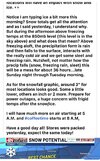
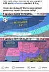
 Official guidance
EMTime
Member
Hello. Nws mem has 1-3 for me tonight, and 3-5 for tomorrow. I'm near tupelo Ms.
SnowWhite
Member
NCHighCountryWX
Member
- Joined
- Dec 28, 2016
- Messages
- 477
- Reaction score
- 1,323
 Official guidance ….
The entire state of Tennessee is under a WSW