Just checked…I’ve had 2.35” of rainfall since 3:00View attachment 140966Just a couple hundred feet down the street from my house. This has never flooded in my 13 years living in this neighborhood… not even during Florence
-
Hello, please take a minute to check out our awesome content, contributed by the wonderful members of our community. We hope you'll add your own thoughts and opinions by making a free account!
You are using an out of date browser. It may not display this or other websites correctly.
You should upgrade or use an alternative browser.
You should upgrade or use an alternative browser.
Severe Jan 8-11 2024 System Severe
- Thread starter SD
- Start date
Can't keep the power on
Under a tornado warning where I am now (Just north of Fayetteville NC), watching that storm coming up from Robeson County
BHS1975
Member
We back!You out?
Sent from my iPhone using Tapatalk
Shaggy
Member
Those cells offshore are something to behold. Beast mode offshore today
Man this wind is just howling. Pressure down to 993mb

Looks like land interaction might be breaking them up a bit
Feels like I am too far north to get anything bad with regards to the wind and storms.
Feels like I am too far north to get anything bad with regards to the wind and storms.
That line to your west means business
Shaggy
Member
Looks like we are right across the river from each other
Attachments
You are. You should probably send the kids outside to frolic in the rain showersFeels like I am too far north to get anything bad with regards to the wind and storms.
I know it this one was a close call round two will be passing through just as the sun sets, these are some fast movers.Looks like we are right across the river from each other
Holy cow check out Johnnie Mercer.
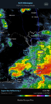
Holy kinks in the line. Do not like how that looks on velo west of the Triangle
Rah is going to have to blanket a tornado warning for the entire lineHoly kinks in the line. Do not like how that looks on velo west of the Triangle
It really sounds like a TS outside with constant roar, pretty insaneMan this wind is just howling. Pressure down to 993mb
rdu gusted to 51 20min agoIt really sounds like a TS outside with constant roar, pretty insane
The wind is really picking up now.
Oh man Surf City looks like it might take a direct hit
Horry CHIT! Yeah it's pretty bad here in Surf City.. I cannot even see across the street for HEAVY RAIN & high winds!Oh man Surf City looks like it might take a direct hit
My neighbor is washed out. This is his old camper he keeps behind the house several feet above the creek/river
- Joined
- Jan 23, 2021
- Messages
- 4,603
- Reaction score
- 15,199
- Location
- Lebanon Township, Durham County NC
Little bit surprised the lack of lightning
Surf City fishing pier taking a pounding!
 www.surfchex.com
Surf City Fishing Pier "T" Live Cam + Coastal Weather | Surfchex
Watch the Surf City Fishing Pier "T" live cam with real-time coastal weather, wind, water conditions, and beach activity from Surfchex.
- Joined
- Jan 23, 2021
- Messages
- 4,603
- Reaction score
- 15,199
- Location
- Lebanon Township, Durham County NC
TOR warning Bahama moving NE
Shaggy
Member
Surf city in trouble
Ron Burgundy
Member
Good Lord - that looks like an oil rig in a hurricane 50 miles off shore! ?Surf City fishing pier taking a pounding!
Surf City Fishing Pier "T" Live Cam + Coastal Weather | Surfchex
Watch the Surf City Fishing Pier "T" live cam with real-time coastal weather, wind, water conditions, and beach activity from Surfchex.
Round #2 coming across Bald head as I type, right before the main event coming from ,, to our West..Surf city in trouble
Rain was so freaking heavy it sounded like, someone dumping pea gravel on the roof..
notice the camera "Shaking" with the oncoming waves?Good Lord - that looks like an oil rig in a hurricane 50 miles off shore! ?
Shaggy
Member
Wind is roaring here.Round #2 coming across Bald head as I type, right before the main event coming from ,, to our West..
Rain was so freaking heavy it sounded like, someone dumping pea gravel on the roof..
All clear now. You can see how high the creek came


Rain is mixing down the gusts, power is flickering over here.Wind is roaring here.
Downeastnc
Member
Weak CC drop when the Surf City cell moved onshore....
Main line looks to be weakening. Much broader rain shield now.
BHS1975
Member
Winds hitting 50 plus here.
Sent from my iPhone using Tapatalk
Sent from my iPhone using Tapatalk
Loosing the sun helped to weaken instabilities?Main line looks to be weakening. Much broader rain shield now.
Did your wind kick up in the past 20 mins? It's outrageous here worst of the dayMain line looks to be weakening. Much broader rain shield now.
BHS1975
Member
Reminds me of being in an eyewall.
Sent from my iPhone using Tapatalk
Sent from my iPhone using Tapatalk