Not a bad snow event I’m glad I didn’t get fringed as badly by the dry slot that the HRRR was advertising. I got some nice grassy accumulation, but it’s still not anything more than I’ve seen since Dec 2018, besides maybe Feb 2020, but not by much.


Snow. They also have areas near town that are 900 plus feet in elevation.Why does everyone always talk about Roxboro ? What about Yanceyville or Oxford ? What's so special about Roxboro ?
Bc if you live here and watch the local news 9 times out of 10 it's struggling to snow/accumulate then they show Roxboro and it looks like they are in the arctic circleWhy does everyone always talk about Roxboro ? What about Yanceyville or Oxford ? What's so special about Roxboro ?
The second I walked in the house i saw the TV on local news and sure enough a reporter was standing in Roxboro showing the snow .Bc if you live here and watch the local news 9 times out of 10 it's struggling to snow/accumulate then they show Roxboro and it looks like they are in the arctic circle


And they have a Golden Corral! ?Bc if you live here and watch the local news 9 times out of 10 it's struggling to snow/accumulate then they show Roxboro and it looks like they are in the arctic circle
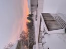
Postcard worthy!! ???
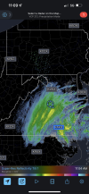
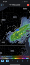
Any storm total maps or data made yet?
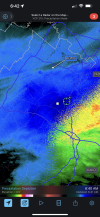
I had between 2 and 2.5" in Summerfield, NCI'll be working on storm total maps later today. Waited on new CoCoRaHS data to come in this morning to help fill in the gaps and have been tired/busy with work and traveling. Will also take a while to comb through this thread and gather additional data I'll need. Was able to save mPING reports which were important in identifying trace amounts SE of the Triangle area down to the central coastal plain
Looks like the visible satellite imagery from this morning is delineating about where at least 2-2.5” or so fell yesterdayI had between 2 and 2.5" in Summerfield, NC
Pardon my ignorance, but do you have a link to the image you viewed?Looks like the visible satellite imagery from this morning is delineating about where at least 2-2.5” or so fell yesterday
Pardon my ignorance, but do you have a link to the image you viewed?


")

God what an arrogant ass this guy is . Hope he is on here and reads that.Apparently DT got one right????? Blind squirrel, ? situation???View attachment 101827
DT reminds me of a broken clock lmaoGod what an arrogant ass this guy is . Hope he is on here and reads that.