Shaggy
Member
Yeah we dig that energy a little more and go a little more nuetral.and it would get my interestYes we both need something similar here slightly south and more neutral/ negative tilt.
Yeah we dig that energy a little more and go a little more nuetral.and it would get my interestYes we both need something similar here slightly south and more neutral/ negative tilt.
#FishStormLate bloomer- yes please. Seriously that is extremely close ???
Geez that’s a lot of bone dry maps
If we could flatten the Apps, we might get a flurry across the Piedmont.
Yeah, unless there are big changes at 500mb, we are going to get shutout with this one.If we could flatten the Apps, we might get a flurry across the Piedmont.
I see places down east seeing some wet snow but for us west of 77/85 downsloping is going to ruin the day as usual.Yeah, unless there are big changes at 500mb, we are going to get shutout with this one.
It's a good thing I bought a sled for Christmas !Yes let this come true!! A dusting will do me right!!!
View attachment 100012
Need that 1033 around Indiana and the low around Pensacola!
Dang, lolView attachment 100033
Trying to think of a time where that kind of setup has ever worked out and I’m coming up empty lol.Hold onnnn View attachment 100034
Just Last year lol, similar progressionTrying to think of a time where that kind of setup has ever worked out and I’m coming up empty lol.
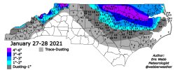
Oh yeah, we got some mixed crap for a couple hours last year on the tail end IMBY, but I don’t care unless it sticks lol. I’m not chasing pixie dust, if we don’t get an inch it’s not worth it haha.Just Last year lol, similar progression
Yeah, worked out well for @metwannabe tho, which I think would do best in this situation, unfor—Oh yeah, we got some mixed crap for a couple hours last year on the tail end IMBY, but I don’t care unless it sticks lol. I’m not chasing pixie dust, if we don’t get an inch it’s not worth it haha.
Beggars can't be choosers. You live in the south. You have to enjoy every single flake.Oh yeah, we got some mixed crap for a couple hours last year on the tail end IMBY, but I don’t care unless it sticks lol. I’m not chasing pixie dust, if we don’t get an inch it’s not worth it haha.
Are you talking about this storm? I had forgotten it was on a tail end deformation band, though I’m probably just having amnesia because of how disappointing it was IMBY. I don’t even get an inch while areas NE got much, much more, and it was the only snow of the winter. And it melted almost immediately and didn’t stick to the street. I need a street sticker for snow to be worthwhile lol.Yeah, worked out well for @metwannabe tho, which I think would do best in this situation, unfor—

That would be fun for many more people if it was just 50 miles south, the lack of ridging out west really kills it for usI mean just give me 50 miles southView attachment 100037
Holy ---- balls thats some dark blueDang, lolView attachment 100033
Yep, that painful piece of crap storm, i was so damn angryAre you talking about this storm? I had forgotten it was on a tail end deformation band, though I’m probably just having amnesia because of how disappointing it was IMBY. I don’t even get an inch while areas NE got much, much more, and it was the only snow of the winter. And it melted almost immediately and didn’t stick to the street. I need a street sticker for snow to be worthwhile lol.
View attachment 100038
Gotcha, I had forgotten the setup. I hated the storm and would like to forget it lol. We got some weenie runs in the run up to it that didn’t come close to materializing.Yep, that painful piece of crap storm, i was so damn angry
That crap in is false. We got some mixed white rain that didnt amount to anything on cars, homes, grass, or streets. However, I guess it became a good deal NE.Are you talking about this storm? I had forgotten it was on a tail end deformation band, though I’m probably just having amnesia because of how disappointing it was IMBY. I don’t even get an inch while areas NE got much, much more, and it was the only snow of the winter. And it melted almost immediately and didn’t stick to the street. I need a street sticker for snow to be worthwhile lol.
View attachment 100038
We had another catastrophe earlier in January where we were supposed to get 1-2” and only got mixed slop.
This looks like round 2 of suckYep, that painful piece of crap storm, i was so damn angry
I don’t know man, I just don’t get a lot out of a storm that doesn’t even stick to the pavement. Feels like a tease. I need more. modernweenieBeggars can't be choosers. You live in the south. You have to enjoy every single flake.
