sackjalding
Member
45 and light rain here in Atlanta (south Buckhead).
are you sure this isn't bias you live in raleigh?Final Call
North Carolina
• Raleigh, NC: 1–2” (Overperform)
• Charlotte, NC: Dusting – Trace
• Mooresville, NC: Dusting – Trace
• Monroe, NC: Trace – 1” (Overperform)
Virginia
• Richmond, VA: Trace – 1”
South Carolina
• Jonesville, SC: Flurries at most
• Columbia, SC: Trace (Overperform)
• Augusta, SC: Trace – 0.5” (Overperform)
• Clinton, SC: Flurries at most
• Clover, SC: Flurries at most
Georgia
• Macon, GA: 2–3”
• Thomson, GA: 1–2”
Florida
• Pensacola, FL: Dusting
Alabama
• Dothan, AL: 1–2” (Overperform)
Yes, a lot of models are hinting at a heavy band towards the end of the event. I think the band will set up to the west of Raleigh and sweep through bringing decent accumulation for the last two hours before moving out!are you sure this isn't bias you live in raleigh?
Just drove through it. It was pretty heavy and the car read 39-40 the whole drive on the back roads.43 and pouring rain in Hogansville GA! 85 SW of ATL
Drying out quick up here. Never got more than a few sprinkles. But definitely blew up just ESE of College Park Bubba Sparxxx.North GA DGZ is are getting moist fast. We'll see what this leads to in the future.
Yes it did! Raining at a good clip too!Drying out quick up here. Never got more than a few sprinkles. But definitely blew up just ESE of College Park Bubba Sparxxx.
I’m an amateur so what is the reason SC gets nothing science wise?
Not at all. Once the front pushes through, that’s the air you have to moisten up.I'm surprised how heavy the rain is here atm....the column is very moist....wonder if that will play a role here several hours from now.
The rain down your way has driven your temp down to saturation. I'm still at 43.7/33.8. The cold is hanging behind Lookout Mountain currently.Down to 41.7 now, but dewpoint is 39.9. .05" of rain under very light returns.
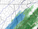
Just for one frame, and it doesn’t even show up on the snowfall map. But… it is trending in our direction. So we’ll have to see as we get closer. In the end that last “NW Trend” call will have to come from nowcasting, not models.03Z RAP says "Watch out, Atlanta"
View attachment 184833
When did the Goofus become a reliable short-range model? I can't see any snow falling let alone accumulating. It's 46 in my backyard right now here in Athens. Looks like some heavy bands of RAIN are heading our way though. And we sure need it.Fwiw gfs has increased totals..has the athens area above an inch now. With Atlanta between a half and inch.
View attachment 184830
The cold is moving in from the west, which is exactly why the modeling is forecasting west central and south west Georgia the snowfall by daybreak. Even Athens is delayed from cold air to the north and west. The worst position from cold air intrusion from the north and west are the areas along the Savannah river, Anderson, Oconee, Hart, Stephens, Franklin, etc. They will be the last to cool down, there is even a valley north of Greenville that allows the cold air to spill out from Hendersonville.When did the Goofus become a reliable short-range model? I can't see any snow falling let alone accumulating. It's 46 in my backyard right now here in Athens. Looks like some heavy bands of RAIN are heading our way though. And we sure need it.
Twister would be ancient history if he was around back in Charlie Gertz days at Wyff 4.CJ posted this earlierView attachment 184835
03Z RAP says "Watch out, Atlanta"
View attachment 184833

It won't, it was never supposed to.I am done trying to figure out if the dry air will be overcome. I shall use hopium and magical "dry-erase" markers to do everything in my power to make this verify. Below is the 03Z HRRR
View attachment 184836
Yeah, you're probably right. But that won't stop me from wishing and probably getting my hopes crushed tomorrow. Oh wellIt won't, it was never supposed to.
Generally it's also good to moisten the bulb right before the front arrives, especially when you may only have a few hours before the next wave of moisture starts trying to make your own push. Absolutely right about having to saturate that one too. Although DGZ is way better and T/D spreads in general is way better than I personally expected, so I am definitely keeping an eye on things going forward.Not at all. Once the front pushes through, that’s the air you have to moisten up.
Well our chance wont be till around after 5 or 6 am. Normally we are screwed in these situations but this setup is a bit different as wind trajectories are not the worst for caa here. If the flow was a bit more northward in the low levels we wouldn't have a chance. Regardless gfs isn't alone in showing increased chances. I have my doubts it will be an inch myself but at least we should see flakesWhen did the Goofus become a reliable short-range model? I can't see any snow falling let alone accumulating. It's 46 in my backyard right now here in Athens. Looks like some heavy bands of RAIN are heading our way though. And we sure need it.
Did clouds move in? Sometimes, that happens. Radiational cooling before these events can be kind of overrated because of that.I’ve gone from 41 at 845 now 46 …. wth? Why are we going backwards? Am I missing something?
Sent from my iPhone using Tapatalk
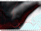
The most interesting part in my opinion about that run was the fact that at 850mb which is right around where the driest air was potentially going to be and cause issues, the latest RAP has much more moist RH values that are further NW and would actually allow snow to reach the ground on the northwest side when compared to earlier short range runs which showed the snow NW but had the very dry air that prevented itRAP 03z was a little bit of an alarming NW tick. May not mean anything, but definitely gotta keep an eye on that.

Yep absolutely may have something to do with the DGZThe most interesting part in my opinion about that run was the fact that at 850mb which is right around where the driest air was potentially going to be and cause issues, the latest RAP has much more moist RH values that are further NW and would actually allow snow to reach the ground on the northwest side when compared to earlier short range runs which showed the snow NW but had the very dry air that prevented itView attachment 184843
When did the Goofus become a reliable short-range model? I can't see any snow falling let alone accumulating. It's 46 in my backyard right now here in Athens. Looks like some heavy bands of RAIN are heading our way though. And we sure need it.
