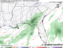
I am literally 20 miles NW of 2-3 inches of snow and about 40 miles from 7 inches per the NAM.... I have seen this play out both ways for my area before we shall see.If I was NW Georgia or NE Alabama I would be feeling pretty good.
Not sure it can/will make it as far NW as Chattanooga, but we will see.
-
Hello, please take a minute to check out our awesome content, contributed by the wonderful members of our community. We hope you'll add your own thoughts and opinions by making a free account!
You are using an out of date browser. It may not display this or other websites correctly.
You should upgrade or use an alternative browser.
You should upgrade or use an alternative browser.
Jan. 17-18, 2026 SE Winter Weather Threat
- Thread starter RBR71
- Start date
Bigedd09
Member
Icon went East. The amount of disagreement with the modeling is crazy
Sent from my iPhone using Tapatalk
Sent from my iPhone using Tapatalk
iwantsouthernsnow123
Member
Eric Webb makes some very good points regarding this. Overrunning setups usually just doesn't favor the Carolinas side of things. Look at 2017, one of the best analogs for this system. Favored the Carolinas, and last 48 or so hours it trended straight to GA, AL, MS. Not that the rest of winter wont have more shots for the carolinas.The hardest hit areas of Upstate are below 85. And we would be so deserving of this to be reality. We have been in the ultimate screw zone for so long. Haven't had more than 3 inches in one storm in a decade.
iwantsouthernsnow123
Member
Models like ICON, Especially global models are not going to be handling this tilt right. Chances are this tilts quite a bit more negatively than ICON shows which is why this will likely trend NW last moment.Icon went East. The amount of disagreement with the modeling is crazy
Sent from my iPhone using Tapatalk
I would definitely cash that out right now. It would be the biggest snowfall IMBY since February 2014Enjoy a Kuchera clown on me this afternoon boys:
View attachment 183891

packfan98
Moderator
Uh, overrunning is great for the Carolinas when there's a High Pressure to the north. CAD storms are the best when you stay cold enough to avoid the sleet and ice.Eric Webb makes some very good points regarding this. Overrunning setups usually just doesn't favor the Carolinas side of things. Look at 2017, one of the best analogs for this system. Favored the Carolinas, and last 48 or so hours it trended straight to GA, AL, MS. Not that the rest of winter wont have more shots for the carolinas.
I haven't heard about the ukmet lately. It was the world's best model a couple of days ago
Bigedd09
Member
Rgem coming in more juiced. May be too warm but we shall see
Sent from my iPhone using Tapatalk
Sent from my iPhone using Tapatalk
NCHighCountryWX
Member
- Joined
- Dec 28, 2016
- Messages
- 700
- Reaction score
- 1,921
NWS GSP Afternoon AFD Official Guidance
Key message 4: We continue to monitor the evolution of model
guidance for Saturday night and Sunday with some interest, given
the consistent GFS depiction of snow potential, but a lack of
consistency between models keeps confidence low.
Another short wave diving into the central CONUS will deepen the
upper trough to our west Saturday night. The short wave and trof
axis cross the area on Sunday. This creates cyclogenesis off the
Carolina coast along the frontal boundary from Saturday. Southerly
flow develops Saturday night with increasing moisture and isentropic
lift across the area. Deep layer forcing and frontogenesis takes
place as well. All of the guidance pretty much agrees on this,
although with some differences where the axis of heaviest precip
develops. They also disagree on the amount of cold air available
when the precip develops. The NAM has come in with enough cold air
and precip for accumulating snow across the area. The GFS remains
cold enough for snow; however, it has shifted the precip axis to our
east limiting the amount of significant snow to our southern and
eastern CWFA boundary. The Canadian remains warm enough for rain for
all the mountains but has shifted the precip axis to the east. The
ECMWF continues to be cold enough, but is basically dry with all the
precip to our east. The GEFS mean continues to shift the precip axis
east but has enough for light snow over our area. The Canadian
ensemble mean also trends with light snow at most. Therefore,
confidence remains low but the chance of accumulating snow
continues. The model blend, and our forecast given the uncertainty,
shows an inch of snow basically along and east of a Greenwood-
Spartanburg-Hickory line with lower amounts to the west. The
eventual result will be highly dependent on the precip axis and cold
air availability, so keep up with the latest forecasts for likely
changes
Rgem coming in more juiced. May be too warm but we shall see
Sent from my iPhone using Tapatalk
RGEM is so much faster than other modeling...might be outside of it's wheelhouse...maybe tomorrow
.gif")
Bigedd09
Member
RGEM is so much faster than other modeling...might be outside of it's wheelhouse...maybe tomorrow
View attachment 183904
Yeah definitely looked much faster. I just can’t believe the disagreement
Sent from my iPhone using Tapatalk
The thing is, both of those would help to dynamically cool the column. Seen it a number of times here over the years in very marginal set ups.You should already be concerned about temps in NC....its going to be extremely hard in the lower levels for you guys, especially with the trend of this consolidating more and introducing more WAA/moisture.
Refer to the official guidance in this caseYeah definitely looked much faster. I just can’t believe the disagreement
Sent from my iPhone using Tapatalk
RGEM is so much faster than other modeling...might be outside of it's wheelhouse...maybe tomorrow
View attachment 183904
RGEM is a horrific outlier it appears when it comes to progressiveness here. SD took the words out of my mouth lol
NAM and AI models in slight disagreement. What’s middle ground between 7 inches and partly cloudy skies?
Yeah it's possible that lp could hug the coast more than depicted on the namRGEM is so much faster than other modeling...might be outside of it's wheelhouse...maybe tomorrow
View attachment 183904
Model trends are madding and all over the place still so much time to go if your within 100 miles of main axis of snow some models have shown your not out yet because shifts are all over. RGEM past 3 runs catching up and more expensive... I will reframe from the RGEM Temp matter and just focus on precip for now
View attachment 183906
18z

View attachment 183906
18z
Attachments
iGRXY
Member
I've got a big feeling that we are going to potentially see a true Hi-RES vs global thing here. The NAM and RRFS are already showing that now. Will be interesting when we come into the CAMs range and HRRR.
I've got a big feeling that we are going to potentially see a true Hi-RES vs global thing here. The NAM and RRFS are already showing that now. Will be interesting when we come into the CAMs range and HRRR.
HRRR has interestingly ticked west of its 12z F048 guidance in its newest run, too.
I do feel we're getting to that point.
NCHighCountryWX
Member
- Joined
- Dec 28, 2016
- Messages
- 700
- Reaction score
- 1,921

NCHighCountryWX
Member
- Joined
- Dec 28, 2016
- Messages
- 700
- Reaction score
- 1,921
Guidance....


Webberweather53
Meteorologist
Lol the GRAF is to the NW vs earlier when it had no precip over the SE US. Still probably out to lunch
iwantsouthernsnow123
Member
Yeah I didn't specify that, there isn't really a CAD in place for this one though. Really relying on a cold front that often lags behind on the mountains there. More specifically WAA overruns the CADUh, overrunning is great for the Carolinas when there's a High Pressure to the north. CAD storms are the best when you stay cold enough to avoid the sleet and ice.
Lol the GRAF is to the NW vs earlier when it had no precip over the SE US. Still probably out to lunch
Judging by that one jump, it still has bit of a way to go.
Piedmont/Foothills of NC
News 12 - 20% chance
News 2 - 30% chance
Fox 8 - 40% chance
All said could change either way, but wasn’t impressed at this time.
Sent from my iPhone using Tapatalk
News 12 - 20% chance
News 2 - 30% chance
Fox 8 - 40% chance
All said could change either way, but wasn’t impressed at this time.
Sent from my iPhone using Tapatalk
Webberweather53
Meteorologist
I’d like my chances with this if I was NE of Atlanta in NE GA so up thru the mountains & foothills of the Apps in NC and possibly even SW VA
Lots to like about where these folks are sitting right now.
When it comes to overrunning style winter storms, I’d much rather be worried about precip occurring than getting the cold air in time, because the precip almost always verifies much higher than forecast.
Lots to like about where these folks are sitting right now.
When it comes to overrunning style winter storms, I’d much rather be worried about precip occurring than getting the cold air in time, because the precip almost always verifies much higher than forecast.
iwantsouthernsnow123
Member
Man, just gotta hope. We're in a crazy snow drought down here in Northeast GA. Really got dry slotted last year too in both systems.I’d like my chances with this if I was NE of Atlanta in NE GA so up thru the mountains & foothills of the Apps in NC and possibly even SW VA
Lots to like about where these folks are sitting right now.
When it comes to overrunning style winter storms, I’d much rather be worried about precip occurring than getting the cold air in time, because the precip almost always verifies much higher than forecast.
GFS with the early westward tick...still.

Man, just gotta hope. We're in a crazy snow drought down here in Northeast GA. Really got dry slotted last year too in both systems.

Some areas of Northern GA got stupendously robbed last year.
GFS with the early westward tick...still.
View attachment 183915
This is not the initial lobe of interest but hopefully we can find a SW tick or better consolidated energy prior to tilting into the Gulf Coast.
iwantsouthernsnow123
Member
Yeah, that system right there I was about 5 miles north of that snow line.
ForsythSnow
Moderator
What I'd like to know is what would be the explanation of this outcome instead of something like what happened last year happening. What're the indicators that it would and examples that it could? I'm starting to lean everywhere north of 85 gets shafted again with this storm entirely based on a too positive tilt in and not enough ridge to push this system more neutral fast enoughI’d like my chances with this if I was NE of Atlanta in NE GA so up thru the mountains & foothills of the Apps in NC and possibly even SW VA
Lots to like about where these folks are sitting right now.
When it comes to overrunning style winter storms, I’d much rather be worried about precip occurring than getting the cold air in time, because the precip almost always verifies much higher than forecast.

The backside of that band in ND/SD is better but further east it appears.

iwantsouthernsnow123
Member
Appears to me that it may be tilting better.
Appears to me that it may be tilting better.
It definitely appears that way for me too. Hopefully see better ridging off to the east at F+54
Not a fan of this trend.
