NCHighCountryWX
Member
- Joined
- Dec 28, 2016
- Messages
- 700
- Reaction score
- 1,921
WPC official guidance updated

Woah that’s aggressive
Sent from my iPhone using Tapatalk
The NWS is being bullish on potential impacts from this potential storm. Let's hope they are seeing something that the models and we are missing out on.Woah that’s aggressive
Sent from my iPhone using Tapatalk
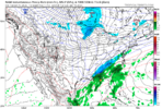
I imagine next 3 days this will change if trends continueFirst WPC map. View attachment 183860
Probably based off ens but I’m not sureThe NWS is being bullish on potential impacts from this potential storm. Let's hope they are seeing something that the models and we are missing out on.

The SHREF is what triggered the warnings in the Foothills right before the storm in 2017. Once it started increasing QPF it never backed down and increased till go time. Probably a little far out for it to be in the wheelhouse at the moment but I will keep my eye on it at the 24-hour and under mark.15z SREF did trend towards the model conensus on precip... but still super bullish and NW with the precip shield.
View attachment 183858
It was the 1st to catch the Crusher in 2000. On an island by itself and then woof 20 hours latterThe SHREF is what triggered the warnings in the Foothills right before the storm in 2017. Once it started increasing QPF it never backed down and increased till go time. Probably a little far out for it to be in the wheelhouse at the moment but I will keep my eye on it at the 24-hour and under mark.
Idk if I would have been that confident to just be throwing out there 4-6 inches especially with how models are currently
He went for it….. 4-6” lol
Sent from my iPhone using Tapatalk
Nope, I wouldn't typically expect such a big change from these ensembles inside 80 hours. Seeing as though all EPS, AIFS-ENS, and WeatherNext2 had similar adjustments, and they all initialize from the same data, there must be something in that data ingest that they are seeing now. I *was* wrong, though, when I suggested that such changes would be unlikely.@bouncycorn this is already like a hundred mile+ jump from the previous WeatherNext solution... earlier you were saying that this kind of jump just doesn't happen within 80 hours on WeatherNext/AIFS -- is this event maybe the kind of outlier scenario that these models can struggle with and this is just as surprising to you? Or does this fit with your thinking still?
Just seems totally not what I expected based on your earlier comments.
Why are they so bullish? Imo you’ve literally everything working against you for this setup, lack of blocking, progressive flow and WAA mixed with suppression. An awful setup to work with for those east of the mtns. Opposite of your Miller A composites LolWPC official guidance updated
View attachment 183861
He’s buggin Lol. I wonder how he gets away with that because that’s wild engagement bait. This setup is wayyyy to damn volatile to post anything even last year’s was too but this is even worse.
He went for it….. 4-6” lol
Sent from my iPhone using Tapatalk
They utilize the NBM heavily in their forecast so not surprised it lines upThe map looks a little bit based off the NBM but it could be just my interpretation here.

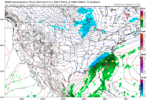
I'd like to know What they are seeing that no one else is to make them throw out those kind of numbersPretty bullish by GSP standards 3 days out View attachment 183862
It’s on chances of 0.1”. Barely a dusting. Probably a fair mapI'd like to know What they are seeing that no one else is to make them throw out those kind of numbers
I still think it's too early to make a call for the Atlanta area. Not saying you will be wrong but think this still has time to change.Nope, I wouldn't typically expect such a big change from these ensembles inside 80 hours. Seeing as though all EPS, AIFS-ENS, and WeatherNext2 had similar adjustments, and they all initialize from the same data, there must be something in that data ingest that they are seeing now. I *was* wrong, though, when I suggested that such changes would be unlikely.
Doesn't change the fact that none of them show a similar solution as the GFS from yesterday. And doesn't change the fact that the GFS/GEFS have largely trended away from that craziness.
It seems that models are honing in on a solution. I still don't expect Atlanta and north to receive measurable snowfall on Sunday.
This isn't even for the main portion of the storm eitherPretty bullish by GSP standards 3 days out View attachment 183862

That red area isn't far from Atlanta. Definitely bears watching.

The budget cuts must've been tough. There wasn't even enough left over to give that guy a bag of cough drops. I don't envy their job right now. I would suppose that watches would be issued by this time tomorrow for the red area if solutions are still consistent