Stormlover
Member
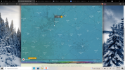
Warning for north miss, and sw tenn 
Looks about right to me. Maybe someone else can elaborate on it.
Looks about within the margin of error....so, yes.
and nothing in bamaWarning for north miss, and sw tenn View attachment 105992
This ^100%. While it’s fine to get excited about your temps not getting up to what they’re expected to, the CAD push is the key, especially if you’re west of 75 & along or south of I-20I don’t necessarily think that potential busting of high temps today = early winter precip in the Atlanta area. It certainly can’t help us to be a few degrees closer, but I think it really comes down to how the wedge drives in this evening. That will tell the story imo. 3K NAM seems to have a good handle on temps so far which is funny cause in the short term it’s colder than the HRRR but long term it’s warmer tonight.
Xcept northeastand nothing in bama
Only 6mph? Looks quite a bit breezier than that here.I’m nervously frustrated. Only 6 mph ene thought at least here east of town…..
It will be interesting to see what HSV does with the afternoon AFD and package.and nothing in bama
Yeah, lets hope. It's concerning, though, with the expected winds. For my backyard, I'm hoping and praying for limited fzrn. I really dislike this type of precip. I'd rather just have plain rain.One thing I think will help with not seeing high level freezing rain accretion in the damming regions is that I believe this storm is going to have precip type evolution / movement. You're either going to be snow to sleet to frz rain.....or sleet to frz rain to rain. So, no long duration time when you are going to be stuck in the frz rain zone
Looking healthy out front View attachment 105985


Noticed that too, they could get buried!Travelers Rest 41/27.
Noticing some snow on radar up toward Caesars Head. Going up in a few to see if it is virga or the real deal!
Sent from my iPhone using Tapatalk


No way areas south of I-20 are getting 3" of snow lol.I hug
Take this however you want to View attachment 105998
Yeah, we are at 48 (8 C), maybe a few degrees above the forecasted high.Already at 45 degrees here which is 4 degrees above the forecasted high. Never a good sign on an already highly questionable event.
I thought I saw a very tiny flurry earlier driving to the store. But it seems to warm for that lolSeeing our first flakes of this event. Flurries

 www.resortcams.com
.gif")
Yes and those single digits are getting closer to the VA/NC borderCheck out this map with the dew points. Notice the dps in the teens up over VA.
WunderMap® | Interactive Weather Map and Radar | Weather Underground
Weather Underground’s WunderMap provides interactive weather and radar Maps for weather conditions for locations worldwide.www.wunderground.com