GeorgiaGirl
Member
GFS says yes again for 1/22-23:

That’s exactly where I want to see a storm at this range, as I said in the banter thread. May still not be far enough south, but it’s a good start.

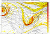
That's what many of us here would like to see. Question is whether the moisture tries to outrun the colder air with that storm.I will just leave this here.
View attachment 10841
That’s exactly where I want to see a storm at this range, as I said in the banter thread. May still not be far enough south, but it’s a good start.
I would expect a bigger system if all the energy gets together correctly.
If the CFS is right that would mean a back loaded winter which was discussed in Nov. and the cliff divers will come back and say we knew it all a longIf and thats a big IF the CFS is right, it will be cold into March.

Yeah I'm looking at them roll in and its at hr252 for me right now. It's going to be a pretty substantial snow mean. More than any previous mean by a good bit.There are going to be some monster storms on the 18 GEFS members in a few minutes...
Wow GEFS looks really good for 1/20, think that's the best it has looked with me looking at it. Let's see how it goes from there.


Since I don't have good GEFS maps to share (mostly all the ensembles), on to the FV3 for me. It says yes to both 1/20 and 1/22 being interesting. In fact, I think it shows what Arcc just mentioned. It also shows what the battleground "could" end up being with 1/22. The energy gets it's act together much quicker, so while it's a SE winter storm, it's much more of a North AL/Tennessee/Far North GA event so far as it's depicted.
Maps:
View attachment 10845
View attachment 10846
18z GEFS mean it’s beautiful!!!!! I wonder if this has been on of the best ones ever???
View attachment 10847
18z GEFS mean it’s beautiful!!!!! I wonder if this has been on of the best ones ever???
View attachment 10847
That low looks to far north into Georgia need to be a little further south
Sent from my iPhone using Tapatalk
Holy ####
Sent from my iPhone using Tapatalk


That would hit board wide except for Phil18z GEFS mean it’s beautiful!!!!! I wonder if this has been on of the best ones ever???
View attachment 10847
Pretty please?Here’s a closer view.
Sent from my iPhone using Tapatalk

18z GEFS mean it’s beautiful!!!!! I wonder if this has been on of the best ones ever???
View attachment 10847

Since I don't have good GEFS maps to share (mostly all the ensembles), on to the FV3 for me. It says yes to both 1/20 and 1/22 being interesting. In fact, I think it shows what Arcc just mentioned about the wave breaking in two, it just starts getting organized a bit late. It also shows what the battleground "could" end up being with 1/22. The energy gets it's act together much quicker, so while it's a SE winter storm, it's much more of a North AL/Tennessee/Far North GA event so far as it's depicted.
Maps:
View attachment 10845
View attachment 10846
I was gonna wait till Monday but I can’t . All my 2019 winter chips are now in the middle for January 20-25th. Ride or die
Sent from my iPhone using Tapatalk

Fire up the thread?? I will do it if you want since I was first to call it, when everyone else was on the bottom of the cliff. ....LOL.I was gonna wait till Monday but I can’t . All my 2019 winter chips are now in the middle for January 20-25th. Ride or die
Sent from my iPhone using Tapatalk
Still have a bit of room on the credit cards for even more if this turns to crap so what the heck, I'll join you with an all-in..I was gonna wait till Monday but I can’t . All my 2019 winter chips are now in the middle for January 20-25th. Ride or die
Sent from my iPhone using Tapatalk
I'll take e1 please!Here’s a closer view.

Sent from my iPhone using Tapatalk
Too soon to worry about the low pressure placement. There are a lot of nice pieces coming together finally.

Please wait until at least MondayFire up the thread?? I will do it if you want since I was first to call it, when everyone else was on the bottom of the cliff. ....LOL.
Fire up the thread?? I will do it if you want since I was first to call it, when everyone else was on the bottom of the cliff. ....LOL.
Thread ? Heck no we don’t even have a specific threat yet .
Sent from my iPhone using Tapatalk