-
Hello, please take a minute to check out our awesome content, contributed by the wonderful members of our community. We hope you'll add your own thoughts and opinions by making a free account!
You are using an out of date browser. It may not display this or other websites correctly.
You should upgrade or use an alternative browser.
You should upgrade or use an alternative browser.
Pattern Jammin January 2024
- Thread starter SD
- Start date
Well I doubt that, but last time you see below 20 probably17.6 this morning. Shame it's the last below freezing temp until winter 24-25
It was sarcasm since we only cancel winter here now, also I would not surprised if it's not the last sub 20Well I doubt that, but last time you see below 20 probably
Brent
Member
Icy mess here... But the warmup at least for a week or so is coming and I cant wait


What we’ve seen here in the last week wasn’t run of the mill cold. It was cold and it has had some staying power. Memorable stretch of winter weather for our western posters no doubt about it. Key takeaway is it can and will still get cold enough to deliver. I think the good news for the eastern half of the board is we don’t need a deep cold press like we saw last week in order to get snowed on. We just need it coming from the right direction.
Blue_Ridge_Escarpment
Member
Tomorrow has all of a sudden set up to be a nasty CAD day for the immediate CAD regions. Drizzle and mid 30s all day
iGRXY
Member
Yeah the 3K has me sitting in the upper 30's for highs. Even the long range HRRR which tends to be too warm at this lead has me sitting at 42 for a high.Tomorrow has all of a sudden set up to be a nasty CAD day for the immediate CAD regions. Drizzle and mid 30s all day
olhausen
Member
I saw on the news this morning a huge garbage truck sliding down the street in nashville.Icy mess here... But the warmup at least for a week or so is coming and I cant wait


We are about .25-.33 of rain tomorrow from losing Wednesday as a warm day around here. If we lock in this residual insitu wedge it would be pretty stubborn to get out
olhausen
Member
I’m pretty sure it was my coldest 7 day stretch living in Nashville. Just finished going over the weekly temps and it was extremely cold. The 7 day high from last Monday through Sunday was 24 degrees. The average low was 2 degrees for a mean temp of 13 degrees. 4 times the low temp dropped to zero or lower with 3 of those nights going negative. The coldest nights were -8 and -6. It snowed on 3 different days with snow falling almost 24 hours straight Sunday night into Monday night and light ZR for hours on Thursday. I ended up with 7.25 inches of snow for the entire week and a glaze of ice. It’s definitely one of the most memorable winter weeks I’ve had.What we’ve seen here in the last week wasn’t run of the mill cold. It was cold and it has had some staying power. Memorable stretch of winter weather for our western posters no doubt about it. Key takeaway is it can and will still get cold enough to deliver. I think the good news for the eastern half of the board is we don’t need a deep cold press like we saw last week in order to get snowed on. We just need it coming from the right direction.
olhausen
Member
Drizzle Snizzle
Member
Dang the house across the street has way more snow than you doTemp up to 42. Snow’s taking a massive hit but still there.
View attachment 143135View attachment 143136
Brent
Member
I saw on the news this morning a huge garbage truck sliding down the street in nashville.
Oh I definitely believe that... it was an ice rink here this morning and honestly even now with my phone reading 33 degrees it still in spots parking lots especially... I'm so ready for a warmup
olhausen
Member
Yeah the sun beats down on our front yard more than any house in the neighborhood so it’s the first to melt. The backyard however sits in the shade and holds on to the snow a lot longer.Dang the house across the street has way more snow than you do
I lied currently 2917.6 this morning. Shame it's the last below freezing temp until winter 24-25
Brent
Member
I hope it's a long time before I see that much freezing rain again. Day was dominated by ice everywhere
Even with the airport reporting 34(warmest since Thursday) I still saw icy areas an hour ago but we're headed the right direction
Even with the airport reporting 34(warmest since Thursday) I still saw icy areas an hour ago but we're headed the right direction
kennedybb6
Member
So my phone is saying flurries and 36…..
kennedybb6
Member
Don’t worry guys the national guard brought me to work since I wasn’t able to get out of the drivewaySo my phone is saying flurries and 36…..
- Joined
- Jan 23, 2021
- Messages
- 4,602
- Reaction score
- 15,197
- Location
- Lebanon Township, Durham County NC
kennedybb6
Member
We have sleet here
Where is here NC located?We have sleet here
kennedybb6
Member
Right in Monroe nc union countyWhere is here NC located?
The old “fly in the ointment”. Expected 1-2” with temperatures in the upper 20s. Woke up to thundersnow, absolutely ripping fatties, 6” already on the ground and temperatures in the upper teens and it stayed there all day. Then a low of 1 the next morning
CltNative90
Member
Back in the days CMS didn’t cancel school until 6 AM day of. I remember this one like it was yesterday. Thomas and Conklin on WBTV were the only ones talking about the possibility of a surprise on the evening news. I remember waking up multiple times that night looking out the bedroom window, and finally around 1 am or so it looked like a dense fog had set in. The next time I looked the ground was turning white. By daybreak it was a winter wonderland. The next evening made for the best sledding on pure snow I can remember.
Never forget this one. Had just had like .2 frzng rain minor event still on limbs from Saturday. Monday morn news they talking how models had missed ns energy by a 1000 miles and that light snow,beleive atlanta, n ga was occuring. Then later that day had got up to charlotte. But at 6pm news triad ,nws said maybe 1-3 overnight,more off to east. The Fish on chanel 5 evening news Triangle, started honking Raleigh was gonna see its bigest storm ever possibly overnight. As of 11pm triad news guys where filming from Montgomery county, snow was pouring, we where getting lighter snow, about 2 inches and they still insisted 1 to 3 max down our way. Well overnight we caught the pivot as storm went beast mode and I had 15, time you got to eastern part county into chatham triangle 20+ by sunrise. Back towards winston, yadkinvilke, almost nada.
Yall have to understand internet was dial up,new,infant stages still. Only way we got weather was radio,tv. What made bastardi so famous,would come on AM radio every morning wsjs and talk weather for 4 mins max. The good ole days. That dable of ice helped catch every snowflake on trees. Lost power for 7 straight days. Temps hit near 0 next couple nights. Then a few days latter we caught another 5 incher all snow on top
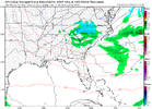
So is this for real or what?. Did I just miss a snowflake?? It's cold and precip above but ..Lil clipper action?
View attachment 143163
if i have to track another thing that relies on trends of more digging and a better tilt i am going to screamIt's trying to be more than clipper action

Add in an extremely marginal air mass and I am out. At least most of the northern stream waves we've gouged our eyes out for recently usually have an Arctic air mass that never makes it in.if i have to track another thing that relies on trends of more digging and a better tilt i am going to scream
Just how cold was this past outbreak?

 share.newsbreak.com

Frozen alligators found in North Carolina as temperatures hit 17 degrees, photos show - NewsBreak
Yes, someone “booped” a frozen alligator’s nose.
You mean you don't like artic cold that latitudinally dives like a friggin' dart for the GoM?Add in an extremely marginal air mass and I am out. At least most of the northern stream waves we've gouged our eyes out for recently usually have an Arctic air mass that never makes it in.
...and I probably should add--longitudinally biasedYou mean you don't like artic cold that latitudinally dives like a friggin' dart for the GoM?
another 5 weeks and 75% of the board will be altitudinally challenged....and I probably should add--longitudinally biased
You’re talking about the Crusher in 2000… these discussions are from the 1/23-24/2003 storm that gave CLT 9” of 40:1 ratio powder when the forecasts were for 1-2”. It was from a very strong clipper that was enhanced by a mesolow that formed over the western SC upstate. The mesolow began showing on short range models during the afternoon with 8 hours of the snow expected to start… GSP referred to it a “the fly in the ointment” in there afternoon discussions.Never forget this one. Had just had like .2 frzng rain minor event still on limbs from Saturday. Monday morn news they talking how models had missed ns energy by a 1000 miles and that light snow,beleive atlanta, n ga was occuring. Then later that day had got up to charlotte. But at 6pm news triad ,nws said maybe 1-3 overnight,more off to east. The Fish on chanel 5 evening news Triangle, started honking Raleigh was gonna see its bigest storm ever possibly overnight. As of 11pm triad news guys where filming from Montgomery county, snow was pouring, we where getting lighter snow, about 2 inches and they still insisted 1 to 3 max down our way. Well overnight we caught the pivot as storm went beast mode and I had 15, time you got to eastern part county into chatham triangle 20+ by sunrise. Back towards winston, yadkinvilke, almost nada.
Yall have to understand internet was dial up,new,infant stages still. Only way we got weather was radio,tv. What made bastardi so famous,would come on AM radio every morning wsjs and talk weather for 4 mins max. The good ole days. That dable of ice helped catch every snowflake on trees. Lost power for 7 straight days. Temps hit near 0 next couple nights. Then a few days latter we caught another 5 incher all snow on top
olhausen
Member

