Athens, GA
Temp: -2.0
Precip: +4.0”
Snow: +1”
Temp: -2.0
Precip: +4.0”
Snow: +1”


We have never seen a pattern this good in our lifetimes.I’d imagine we’re gonna have some noise on the GEFS around the 1/3-1/4 timeframe with this look View attachment 138895
You buy a sled yet?We have never seen a pattern this good in our lifetimes.
The first week of January looks encouraging, probably the most optimistic I’ve been about our snowy prospects in years. I lowballed it on my snow forecast for January, but I personally think January will be our best month for potential here vs February.Half the members on the EPS show snow for the ATL. I expect this grow quickly the next few days for many of us.
View attachment 138941


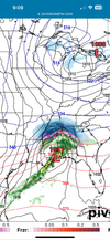
The H5 map on the 06z GFS is just beautiful
View attachment 138952

What an awesome New Year’s Day this would be if it actually verified
Can score in with lakes low but decent HP needs to be Montreal/upstate NY area and blocked a bitLakes low no bueno.
Sent from my iPhone using Tapatalk
In this case it’s giving us confluence/our cold feed. Perhaps a phaser ?Lakes low no bueno.
Sent from my iPhone using Tapatalk
Boys and girls..... what we have here is a picture of the perfect winter storm pattern for the southeast. "It don't get no better than that".The H5 map on the 06z GFS is just beautiful
View attachment 138952
To bad it’s 6z gfs lolBoys and girls..... what we have here is a picture of the perfect winter storm pattern for the southeast. "It don't get no better than that".

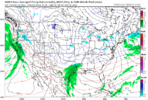
I don’t think we’re gonna get the perfect setup every run.Euro might try again, but personally like the look the 00z had more in regards to the EC trough, and weakness under the western Canada ridge View attachment 138967
Just analyzing rtrI don’t think we’re gonna get the perfect setup every run.


So what, it looks like, the effing SER?View attachment 138976
I’ve been looking for weeks for something like this to show up…. Please hang in there ????
No that not a SER. You can tell it on the 500mb charts. It’s just a strong Arctic front with a strong southerly push of warm air out ahead of it. Doesn’t really matter much since it’s hour 384 of the OP GFSSo what, it looks like, the effing SER?


Come on this like years past ,,21 is Seattle, give me a breakNo that not a SER. You can tell it on the 500mb charts. It’s just a strong Arctic front with a strong southerly push of warm air out ahead of it. Doesn’t really matter much since it’s hour 384 of the OP GFS
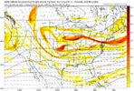
Also looking at the teleconnections the last couple days, they really are following how would expect unfold climo-wise for a moderate to strong El Niño. The AO is about to tank just after the first of the month and the NAO is headed negative as well so there should be good blocking setting up. The PNA does start to go negative as the Pacific jet retracts again but like you said that process should help to beef up the -NAO.Gotta watch these looks on the ens with the southern stream and deep Atlantic confluence. If we’re gonna pop a winter storm up, it’s somewhere close to this exact look. View attachment 138990View attachment 138991


Again it was hour 384 from the OP 12z GFS. The 18z has a fairly good overrunning snowstorm for northern GA and the Carolinas in that same timeframeCome on this like years past ,,21 is Seattle, give me a break
The lower heights over the NE and northern Atlantic is really very similar to January 2022 when we here in the NC Piedmont had 3 straight weekends with accumulating snow. The big difference is how active the STJ is staying on these looks… in 2022 we were depending solely on northern stream energy as the STJ was virtually non-existingThis gefs run is good examples of how we snow. Constant confluence from the low heights in the NE/Atlantic, active southern stream, which then the translates to more confluence as stream interaction happens and it moves to our east/NE, and more southern stream moving in. loaded diaper pattern. Gefs has this look a couple times View attachment 138995
View attachment 138992View attachment 138993View attachment 138994
Yeah the southern stream that year didn’t wanna play fair at all. But those setups had some very deep, legit cold as well, these ens looks showing up look warmer, more marginal, but that’s typical for a El Niño. Very good look coming imo. Better then anything last winterThe lower heights over the NE and northern Atlantic is really very similar to January 2022 when we here in the NC Piedmont had 3 straight weekends with accumulating snow. The big difference is how active the STJ is staying on these looks… in 2022 we were depending solely on northern stream energy as the STJ was virtually non-existing
Absolutely. I also believe that CAD could be very stout with these looks. One thing that’s going for us east of the mountains is the fact that eastern Canada has managed to hold on to a fair amount of snowpack. These lower heights should lead to some good high pressure placement over the NE to tap into that cold air.Yeah the southern stream that year didn’t wanna play fair at all. But those setups had some very deep, legit cold as well, these ens looks showing up look warmer, more marginal, but that’s typical for a El Niño. Very good look coming imo. Better then anything last winter