• Hello, please take a minute to check out our awesome content, contributed by the wonderful members of our community. We hope you'll add your own thoughts and opinions by making a free account!

Pattern Jammin January 2024

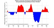
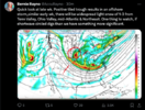
What looked very promising is now fading very fast...the pattern starts to collapse which doesn't allow the energy to dig southwest like we need. It's really a shame. But the good news is we warm up and get to do the whole death by million cutters again for Feb.

View attachment 142191

Pretty much what Bernie said...we do suck

Screen Shot 2024-01-14 at 9.48.43 AM.png
 
I'm done with northern stream energy period. Trying to get it to drop in and dig and tilt correctly isn't going to work 9 out of 10 times. It's just like what we have now. Bad tilt and dries up east of the Apps then blows up off the coast and maybe scrapes the outer banks and NE. CAD driven storms are about the only hope in that and they require confluence off the NE coast. The only 2 big storms in 5 years (Dec 2018 and Jan 2022) were CAD storms. Where is the southern energy with Baja lows that's so prevalent in Ninos? This Nino has been broken the whole time. It didn't even rain in Oct and November. Now all the rains are mostly from cutters and severe weather from a warm juiced up Gulf.
Great post actually
 
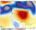
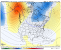
Let's hope the PNA is further east as depicted by the EPS, and not back toward Alaska like the GEFS. Otherwise, it's Groundhog Day again. I'm done with arctic highs dropping into Montana. Give me some 1040+ highs into the Great Lakes and NE.
eps_z500a_namer_61.png

gfs-ens_z500a_namer_65.png
I'll also add that I would like to see something in the middle of the two. Or even the GEFS over the EPS. When relying on northern stream energy you absolutely can't win if it's positive tilt until offshore. No way. However more west gives it time to turn negative and amplify. Surely it'll probably cut most times but you can always time that big 1040 high sliding in tandem and keep it taking the low road. At least that way gives a chance. Maybe my analysis is wrong. But I've seen so much northern stream failure lately I don't know what works now. I feel an active southern stream with energy entering Baja would work with either the EPS or GEFS but I'm not sure if that'll show up or not.
 
I'll also add that I would like to see something in the middle of the two. Or even the GEFS over the EPS. When relying on northern stream energy you absolutely can't win if it's positive tilt until offshore. No way. However more west gives it time to turn negative and amplify. Surely it'll probably cut most times but you can always time that big 1040 high sliding in tandem and keep it taking the low road. At least that way gives a chance. Maybe my analysis is wrong. But I've seen so much northern stream failure lately I don't know what works now. I feel an active southern stream with energy entering Baja would work with either the EPS or GEFS but I'm not sure if that'll show up or not.
Supposedly, a +PNA is coming. That will help get S/Ws far enough south. Cold air and where energy decides to make the turn will be determined at game time. Hopefully strong Nino doing strong Nino things will keep the southern stream active. We'll see.
 
A stationary Hudson bay vortex is the kiss of the death for us, but 360 hr+ ensembles are always gonna have that there with the a west coast ridge. So no reason to panic on that.

Overall, you can't ask for a much better look on 360 hr ensemble means.

Kiss of death for those in the Armpits of the US, not so much for those in the Heart of Dixie.
 
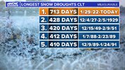
Where did you see Panovich say that? His vlog yesterday morning he was only talking flurries and no big deal for either system. He's more focused on getting a T to say we broke the snow drought.
I am fairly certain that he said the other day that he felt like that late week system was one that he felt would trend southward from what the models were showing the other day.
 
I'm done with northern stream energy period. Trying to get it to drop in and dig and tilt correctly isn't going to work 9 out of 10 times. It's just like what we have now. Bad tilt and dries up east of the Apps then blows up off the coast and maybe scrapes the outer banks and NE. CAD driven storms are about the only hope in that and they require confluence off the NE coast. The only 2 big storms in 5 years (Dec 2018 and Jan 2022) were CAD storms. Where is the southern energy with Baja lows that's so prevalent in Ninos? This Nino has been broken the whole time. It didn't even rain in Oct and November. Now all the rains are mostly from cutters and severe weather from a warm juiced up Gulf.
Great post!! It’s always a balancing act with N/S energy. It did work out for a lot of us with that big storm in mid January 2018 without CAD, but with a Lee side enhancement. The only issue with southern stream is that it can get so amped up even with good confluence and a strong CAD in place it rushes in that warm nose and we end up with an ice or sleet storm. Also you brought up a great point in your other post about the high dropping in too far east vs too far west. Dropping in over Montana does give the energy more time to dig and perhaps we can luck out and get a high moving in tandem with it. Highs dropping in over the Great Lakes concern me because it sometimes sets up too progressive a pattern. Hopefully when we see this good western ridge pop we will get somewhere between the EPS/GEFS. I would really like to see Webb’s thoughts on that… he’s basically nailed this progression to a tee all season.
 
I'm done with northern stream energy period. Trying to get it to drop in and dig and tilt correctly isn't going to work 9 out of 10 times. It's just like what we have now. Bad tilt and dries up east of the Apps then blows up off the coast and maybe scrapes the outer banks and NE. CAD driven storms are about the only hope in that and they require confluence off the NE coast. The only 2 big storms in 5 years (Dec 2018 and Jan 2022) were CAD storms. Where is the southern energy with Baja lows that's so prevalent in Ninos? This Nino has been broken the whole time. It didn't even rain in Oct and November. Now all the rains are mostly from cutters and severe weather from a warm juiced up Gulf.
That’s what I’m saying, give me CAD or give me death
 
I'll also add that I would like to see something in the middle of the two. Or even the GEFS over the EPS. When relying on northern stream energy you absolutely can't win if it's positive tilt until offshore. No way. However more west gives it time to turn negative and amplify. Surely it'll probably cut most times but you can always time that big 1040 high sliding in tandem and keep it taking the low road. At least that way gives a chance. Maybe my analysis is wrong. But I've seen so much northern stream failure lately I don't know what works now. I feel an active southern stream with energy entering Baja would work with either the EPS or GEFS but I'm not sure if that'll show up or not.
The key with the northern stream stuff is that the wave / trough has to drop down into an already existing cold trough where the warm / cold boundary is to our south (we have examples). Right now, the boundary is right on top of us so it takes magic dust to make it work east of the Apps. It’s working for TN though
 
The key with the northern stream stuff is that the wave / trough has to drop down into an already existing cold trough where the warm / cold boundary is to our south (we have examples). Right now, the boundary is right on top of us so it takes magic dust to make it work east of the Apps. It’s working for TN though
What has changed since the 80's & prior?
I might believe it was AGW if the entire southern region from Dallas to the Atlantic was missing these systems.
But that can't be it.
It's like the pattern has changed so drastically that all the cold air dumps from Dallas to Birmingham.
80's even in the 90's those systems didn't just stall west of the Apps.
In fact if places were going to get cold in that general region it seemed like it would always get colder East of the Apps more so than West or it hit everyone.
Its not like the Apps just formed in the last two decades.
I never remember Dallas to Birmingham receiving more snow than the Carolinas.
What's driving this drastic change?
And who do we need to sacrifice to get it reversed?
Brick???
Serious question for you guys who have been around for sometime as I but have a general idea what's causing this?
I can't answer for Grit, but I've seen Brad Panovich elaborate some on this. He's said for awhile now the extreme blocking in the Arctic is the cause. Each action has an equal and opposite reaction. In this case the intense blocking is causing very deep troughs in response. And the deeper they are the more narrow they are and the less likely you are to be in the right spot to cash in. But idk. I'm not sure anyone really knows what's changed, but something has.
 
Ive been around a while in NC. You younger guys keep throwing around how great the 80s and 90s where. They werent all some crank them up to be. Yea we had a couple noteworthy artic blast (7 dayish in length) , a big snow jan 88. Really those where the highlights. I can remember way to many Above normal winter days and thinking its never gonna snow anymore. The 70s where stellar and the best decade for winter wx in NC imo was 2000-2010. Espeacilly 2000-2004. In central NC you had the crusher,Historic Catatstrophic ice stirm Dec 2002 and the Feb 28,2004 upper level thundersnow beast( 17 inches here).
Bottom line we are in a slump. They come an go down here because of our location. The rubber band will snap back the other way soon. Always does.
 
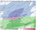
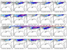
A handful of solid hits for NC on the GEFS for the Friday deal. Only a couple of members show snow down into GA per usual. These totals include the upcoming system as well.

1705252387676.png
 
Ive been around a while in NC. You younger guys keep throwing around how great the 80s and 90s where. They werent all some crank them up to be. Yea we had a couple noteworthy artic blast (7 dayish in length) , a big snow jan 88. Really those where the highlights. I can remember way to many Above normal winter days and thinking its never gonna snow anymore. The 70s where stellar and the best decade for winter wx in NC imo was 2000-2010. Espeacilly 2000-2004. In central NC you had the crusher,Historic Catatstrophic ice stirm Dec 2002 and the Feb 28,2004 upper level thundersnow beast( 17 inches here).
Bottom line we are in a slump. They come an go down here because of our location. The rubber band will snap back the other way soon. Always does.
IMG_0873.jpeg
Yep
 
Back
Top