Wish the ICON had more frames


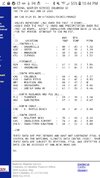
Pretty interesting this is very close to what actually happened today, at least in SC. GSP had a high of 45, CAE 66, CHS 74!View attachment 131332
It would be interesting to do a poll to see who would want to be in the wedge and who would want to be in the orange. I think i know how a few would answer. Without a doubt, I would want to be in the wedge here; keep 60s and especially 70s as far away from me as possible in the heart of "winter."
Just looks like rain to meIs this good?

Yes, Texas needs the rain as we head into spring and summerIs this good?
Icon was about to bury youJust looks like rain to me
Look closely you can see the top edge of the precip is blue in northern AL/GA. If the 1048 moved in tandem with the precip, or even held firm, there would likely be a lot of frozen in the northern fringe. That's a HUGE moisture feed too. Not sure about the speed of the precip feild or the column temps, but just verbatim that's a classic look you hope to see.Is this good?
LOL. That was tongue-in-cheek. I'll take that look and cash out tonight.Look closely you can see the top edge of the precip is blue in northern AL/GA. If the 1048 moved in tandem with the precip, or even held firm, there would likely be a lot of frozen in the northern fringe. That's a HUGE moisture feed too. Not sure about the speed of the precip feild or the column temps, but just verbatim that's a classic look you hope to see.

That low is already neutral, we wouldn't want that to go negative for a long time yet or we get the cut with tropical air treatment. Keep it neutral and low. Always a fine line.ICON ?

You can thank that stronger cold push for the further south high pressure. No way that high can resist that large of a cold air mass. Creates the perfect overrunning setup too. Would be nice to see show up with other model runs.And, that gorgeous high should be crawling ESE from what is shown at 180.

I would think it would tend to stay neutral or even weaken as it continues east into that wnw-oriented confluence.That low is already neutral, we wouldn't want that to go negative for a long time yet or we get the cut with tropical air treatment. Keep it neutral and low. Always a fine line.
Yea, it's a perfect map... you couldn't draw it up any better for CAD area's. Probably mostly sleet and freezing rain from Atlanta to Columbia... but would be mostly snow along and north of 85, maybe changing to sleet and freezing rain later on... as depicted it was setting up to be a prolonged 24-36hr event.I would think it would tend to stay neutral or even weaken as it continues east into that wnw-oriented confluence.
Speculation off a 180-hour model is of course whamby worthy, but there it is anyway.
Whether iT shows a storm or not I think we’re heading into the right direction with the storm kicking out faster and there for making the initial storm push have much more moistureMaybe not, I’m going to shut the f up
How do I find this noaa chart of Temps for Charlotte? Thanks so muchPretty interesting this is very close to what actually happened today, at least in SC. GSP had a high of 45, CAE 66, CHS 74!
https://www.weather.gov/gsp/observationsHow do I find this noaa chart of Temps for Charlotte? Thanks so much

Wow didn’t think the euro was going to look that good.. makes sense with how its ensembles have been trending. This was a fairly decent (major?) ice storm for the CAD regionsWell this will get the board hopping in the morning....
Increase in wintry members in the GEPS .. still some support on the GEFS from the same amount of members that have had the event all day and now the euro coming in with a CAD event .. if the high pressure can come in quicker than it’s an even bigger deal. Slow steps but I like that we’re trending this way closer under 200 hours now
Yep only reason GFS didn’t show anything was cause it doesn’t see the high pressure at all.. a lot of the GEPS members I saw had a pretty droid high pressure but in all different locations and all different timings as well. Which makes for different events. ICON was the most beautiful in regards to timing thoughI mean a actual 1045 high over NE usually is bank for NC at least....need the low track further south so we get more blue and less red/pink on the map....if that low off the coast the last several frames was 100 miles further east it would help a lot. Still its 10 days out so the big take away is the models trending to strong high over NE that actually hangs out a few days....
.png")


9 days away? Doubt to much hoppingWell this will get the board hopping in the morning....

Not trying to be negative, but as good as that high looks, what’s to keep it from sliding out too quickly. It just looks to me like we’re relying on absolute perfect timing and 9 days out we know that usually goes.Euro has 23-27 degree freezing rain for the piedmont of NC .. yeah again we’re much closer to a CAD event then people may try to make you believe in here.


Not trying to be negative, but as good as that high looks, what’s to keep it from sliding out too quickly. It just looks to me like we’re relying on absolute perfect timing and 9 days out we know that usually goes.