-
Hello, please take a minute to check out our awesome content, contributed by the wonderful members of our community. We hope you'll add your own thoughts and opinions by making a free account!
You are using an out of date browser. It may not display this or other websites correctly.
You should upgrade or use an alternative browser.
You should upgrade or use an alternative browser.
Tropical Hurricane Nate
- Thread starter ForsythSnow
- Start date
There is nothing to slow this down. It's embedded in a very fast flow
WarEagle22
Member
There is nothing to slow this down. It's embedded in a very fast flow
Exactly. I think it could make landfall much sooner than midnight as predicted.
Last 2 NHC updates have shifted the cone ever so slightly west.
Storm5
Member
I agree, it will make landfall before midnight no doubtExactly. I think it could make landfall much sooner than midnight as predicted.
Sent from my SM-J320VPP using Tapatalk
Storm5
Member
Yes they have and I'm a little surprised to be honest . I still Think there is a little more room east but I could be wrong. Happens all the tineExactly. I think it could make landfall much sooner than midnight as predicted.
Last 2 NHC updates have shifted the cone ever so slightly west.
Sent from my SM-J320VPP using Tapatalk
I agree. I could see the inland track a little east as well. Either way time is running out for super RI
Xtreme Weather
Member
Nate appears to be coming into another let’s call it enhancement vs RI cycle deep convection with colder cloud tops starting to flare up...see if any gas left in the tank
Storm5
Member
Current watches and warnings

Sent from my SM-J320VPP using Tapatalk

Sent from my SM-J320VPP using Tapatalk
ForsythSnow
Moderator
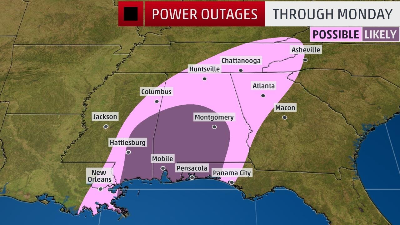
Winds came out of the N and NE with Irma, and will be from the S and SW with Nate. Wonder how that will affect the everything power wise.
gawxnative
Member
IMO in Atlanta Metro.. biggest issue reference wind will be trees with prior damage (undetected/weakened root structures) from Irma, coupled with were feeder band(s) line up..( Pretty healthy looking one fired up across Cuba,) and the related spin up threats... Much more unstable than with Irma to say the least
Doesnt appear that there will be much impact from wind here in west ga. FFC says 10-20 mph sustained with gusts to 35. Im surprised they havent dropped the TS Watch with winds that low.
Stormlover
Member
nothing has changed, why would they drop it?Doesnt appear that there will be much impact from wind here in west ga. FFC says 10-20 mph sustained with gusts to 35. Im surprised they havent dropped the TS Watch with winds that low.
Snowflowxxl
Member
Yea I agree. For a good portion of the watch only predicting like 2 inches of rain and 25 mph gust. Doesn't really warrant a watch IMODoesnt appear that there will be much impact from wind here in west ga. FFC says 10-20 mph sustained with gusts to 35. Im surprised they havent dropped the TS Watch with winds that low.
Im not sure but yesterday they said 20-30 mph sustained winds and now its 10-20 mph. Maybe tonight they will lower it to calm winds. Who knows.nothing has changed, why would they drop it?
Storm5
Member
Slight west shift inland

Sent from my SM-J320VPP using Tapatalk

Sent from my SM-J320VPP using Tapatalk
Xtreme Weather
Member
Can see the convection trying to wrap around on vis
https://www.ssec.wisc.edu/data/geo/...l=01&image_quality=gif&anim_method=javascript
https://www.ssec.wisc.edu/data/geo/...l=01&image_quality=gif&anim_method=javascript
Just as you predictedSlight west shift inland
Sent from my SM-J320VPP using Tapatalk
Storm5
Member
No I've been wrong , I though it would shift east. Still feel that wayJust as you predicted
Sent from my SM-J320VPP using Tapatalk
Imo it's almost a due North movement right now

