-
Hello, please take a minute to check out our awesome content, contributed by the wonderful members of our community. We hope you'll add your own thoughts and opinions by making a free account!
You are using an out of date browser. It may not display this or other websites correctly.
You should upgrade or use an alternative browser.
You should upgrade or use an alternative browser.
Tropical Hurricane Isaias
- Thread starter Snowfan
- Start date


Thanks for posting by any chance you have a qpf map from the 6z Euro too?
Thanks for posting by any chance you have a qpf map from the 6z Euro too?
Yep...here you go.


This still needs to be watched carefully, looks like it's trying to reorganize offshore.


Sorry man, we posted that at the same time.... it really looks less pathetic atm
Webberweather53
Meteorologist
Looks like Isaias's low level center is reforming downshear this morning, could have track implications in the Carolinas if it manages to stick the landing.
Current IR sat looks eerily similar....It is worth noting that if the HRRR is right again (as it had Isaias starting to look better around this time) it has Isaias looking like this in about 11 hours:
View attachment 45754
And has some steady development through the night, so we'll see what happens.
Looks like Isaias's low level center is reforming downshear this morning, could have track implications in the Carolinas if it manages to stick the landing.
This would mean a stronger storm? Could this mean a further east track?
Further east and stronger would be better for most with impacts shifting East to the OBX.
Webberweather53
Meteorologist
This would mean a stronger storm? Could this mean a further east track?
It could mean both here, but I'm somewhat doubtful it'll be able to hold on for too terribly long.
Cary_Snow95
Member
Is it possible that rather than reformation it just gets decoupled again?It could mean both here, but I'm somewhat doubtful it'll be able to hold on for too terribly long.
Downeastnc
Member
This thing either reorganizes under the MLC off the coast or its toast...if it does that then the SC/NC border landfall's we see on many models with a more N movement right up the I95 hwy 17 corridor.....still I wont lie I expected it to be nothing when I woke up so it looks way better on sat than I was expecting.
Also that Ukie sure is consistent with landfall and strength and has been the model to keep it east of Florida, and frankly climo wise its the most likely, storm stays 100 or so miles or more offshore of the SE north of central Florida and plows into the SC/NC border heading NNE, I mean its a favored track for a reason....also its wind clown maps are woof.


Also that Ukie sure is consistent with landfall and strength and has been the model to keep it east of Florida, and frankly climo wise its the most likely, storm stays 100 or so miles or more offshore of the SE north of central Florida and plows into the SC/NC border heading NNE, I mean its a favored track for a reason....also its wind clown maps are woof.
Webberweather53
Meteorologist
Imo, Tropical Storm Hanna (2008) is a pretty good analog for what we can generally anticipate area-wide w/ Isaias tomorrow night into Tuesday morning in the Carolinas.
Shaggy
Member
@Webberweather53 If the center does move closer to grand bahama under the deeper storms then that would have to be a somewhat significant development. At least in the since of track up the east coast.
Attachments
Cary_Snow95
Member
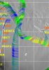
There is a period of time where this system is E of the Ga coast and the shear backs off a little bit. At the same time you have the system in the right entrance of the jet. This would be the window for quick intensification as well as blossoming a large precip shield north of the track. .png")
As this moves north from here we are likely to see the precipitation shift to LOT toward the trough axis with help from the increasing jet streak to the north
As this moves north from here we are likely to see the precipitation shift to LOT toward the trough axis with help from the increasing jet streak to the north
Imo, Tropical Storm Hanna (2008) is a pretty good analog for what we can generally anticipate area-wide w/ Isaias tomorrow night into Tuesday morning in the Carolinas.
I remember this one well. Sat on the apartment balcony and watched it rain buckets with nearly constant lightning. The wind didn't start really ripping until we almost got on the back side of the system and rain tapered down
LickWx
Member
Imo, Tropical Storm Hanna (2008) is a pretty good analog for what we can generally anticipate area-wide w/ Isaias tomorrow night into Tuesday morning in the Carolinas.
Hanna was my first tropical experience after moving from Charlotte. Charlotte gets jack diddly squat in terms of tropical weather . I very much remember Hanna ! The girl and the storm .
Webberweather53
Meteorologist
There is a period of time where this system is E of the Ga coast and the shear backs off a little bit. At the same time you have the system in the right entrance of the jet. This would be the window for quick intensification as well as blossoming a large precip shield north of the track. View attachment 45800
As this moves north from here we are likely to see the precipitation shift to LOT toward the trough axis with help from the increasing jet streak to the northView attachment 45802
Yeah models typically don't handle this terribly well either