To be honest I seem to remember Dorian doing something like that last year. A lot of modeling was wanting to shred it apart over Hispaniola, but a new center formed in convection to the north and that caused it to miss Hispaniola and go completely nuts in strengthening.I wish I remembered the name and year but there was a system that was interacting with the big islands and a blob of convection remained north offshore. The center jumped and relocated by a decent distance.
Theres no defined center yet unless recon finds one now. This thing can do anything. It can reform south of the islands or north or just never close off. This setup, track and intensity is a good one to throw some curveballs.
I'll sit back watch the trends both visually and modeled and wait and see what he does.
-
Hello, please take a minute to check out our awesome content, contributed by the wonderful members of our community. We hope you'll add your own thoughts and opinions by making a free account!
You are using an out of date browser. It may not display this or other websites correctly.
You should upgrade or use an alternative browser.
You should upgrade or use an alternative browser.
Tropical Hurricane Isaias
- Thread starter Snowfan
- Start date
BHS1975
Member
We need Hispaniola to hack off that vestigial southern part so the north end can take over.
Sent from my iPhone using Tapatalk
Sent from my iPhone using Tapatalk
Cary_Snow95
Member
If you want a hurricane, then yes we “need” that lolWe need Hispaniola to hack off that vestigial southern part so the north end can take over.
Sent from my iPhone using Tapatalk
Webberweather53
Meteorologist
Interesting to note that both the 12z ECMWF & GFS are both trying to develop the next wave immediately behind PTC9/Isaias in the southwest Atlantic next week. May be little rest for the weary
BHS1975
Member
If you want a hurricane, then yes we “need” that lol
No I don’t but some rain would be nice.
Sent from my iPhone using Tapatalk
Cary_Snow95
Member
18z GEFS with a turn out to sea

Downeastnc
Member
A mature storm with a broad strong wind field on that track would give most of NC east of I 95 hurricane gust at least I would think, and maybe even sustained 50-60 mph winds in the NE and E eyewalls well inland.....overall though the chances of some kind of TC affecting our backyards sometime Mondayish seems fairly likely even if it is a rem low etc....
Downeastnc
Member
18Z HMON with a pretty solid hit on NC HWRF looks like OTS.....

Jessy89
Member
So now it’s starting to trend to east coast solution. And possibly out to sea.
Sent from my iPhone using Tapatalk
Sent from my iPhone using Tapatalk
Shaggy
Member
So now it’s starting to trend to east coast solution. And possibly out to sea.
Sent from my iPhone using Tapatalk
Yeah it's why I love tropical weather more than anything else. Always changing and keeping you on edge when tracks are this close.
Brent
Member
HWRF may be a total miss certainly other than the OBX
Shaggy
Member
San Juan has seen a 5mb pressure drop since noon.
Webberweather53
Meteorologist

Big moisture surge streaming north towards the Carolinas on the end of the 18z Euro
Cary_Snow95
Member
If it decides to wrap up tonight and strengthen, I almost wonder if that would be more detrimental to its overall health during its trip over Hispaniola. Right now it’s so dispersed and broad it can easily traverse the island and survive. But if it wraps up a good center tonight and then that center gets heavily disrupted..? Idk just a thought
Cary_Snow95
Member
Any 500mb maps from that run?View attachment 45397
Big moisture surge streaming north towards the Carolinas on the end of the 18z Euro
Webberweather53
Meteorologist

Will it’s slight slowdown from 23mph WNW to 18mph WNW affect it over the next few hours or will it not do much? And does anyone know why they canceled the recon mission scheduled for 7pm?
Downeastnc
Member
If it decides to wrap up tonight and strengthen, I almost wonder if that would be more detrimental to its overall health during its trip over Hispaniola. Right now it’s so dispersed and broad it can easily traverse the island and survive. But if it wraps up a good center tonight and then that center gets heavily disrupted..? Idk just a thought
Yeah if it pops a strong LLC south tonight and drags that north it will just kill it....
However looking at some of the maps I wouldnt be surprised to see a newer center organize NW of PR sometime tomorrow as the land interaction of DR to the west and PR to the east let it tighten up a bit there....its just so messy its hard to tell whats going on.....if that new convection around 15N 65W can take over and move NW it might even miss the main islands....
Shaggy
Member
Will it’s slight slowdown from 23mph WNW to 18mph WNW affect it over the next few hours or will it not do much?
Should help it start to close off.
Para was faster and inside the sounds of NC this run.
I feel like we are looking at a EC hit or near curve regardless of strength. Keys to OBX for the wave + with intensification starting before the Bahamas.
00z spaghetti models


78W or greater IVO FL is a hard escape without clipping.


NoSnowATL
Member

Cary_Snow95
Member
Webberweather53
Meteorologist
That’s also assuming that center there will remain the dominant one and that’s not likely
accu35
Member

Cary_Snow95
Member
It really is insane how terrible it looks
Jessy89
Member
It really is insane how terrible it looks
And that area of low pressure still looks way south of modeling
Sent from my iPhone using Tapatalk
accu35
Member
Cary_Snow95
Member
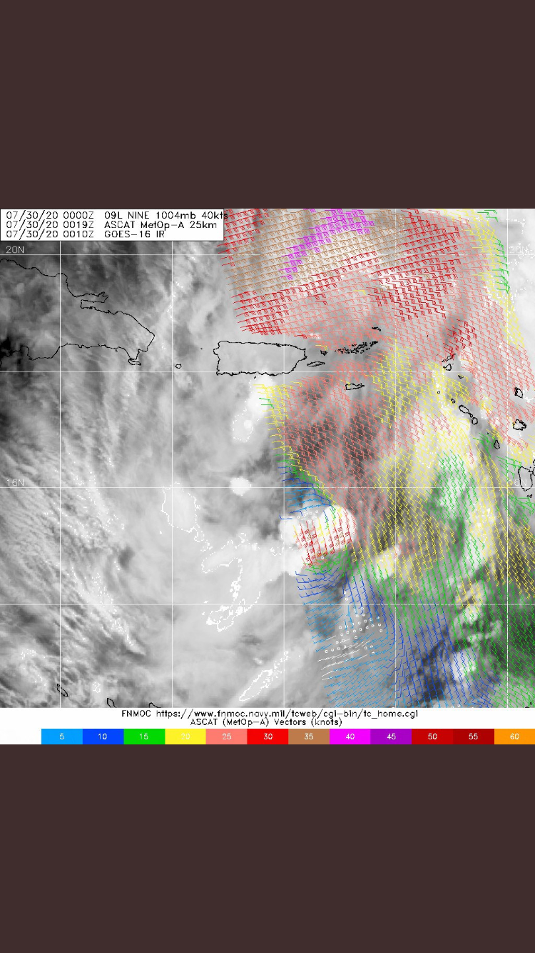
I would think that the new blowup of convection can continue, and looking at the ASCAT pass....my guess....would be that is where the center would form or try to consolidate around.
Shaggy
Member
Still curious with the long stretched wave axis and pressure falls we saw up north if we see a LLC that shifts and relocates a couple times early in its life.
Cary_Snow95
Member
If this strong convection continues overnight it’ll be interesting to see what happens tomorrow afternoon. A stronger southern based center could cause problems once it encounters Hispaniola. Guidance is confident tho that the northern part takes full control within the next 12 hours.I would think that the new blowup of convection can continue, and looking at the ASCAT pass....my guess....would be that is where the center would form or try to consolidate around.
Brent
Member
Isaias coming
AL, 09, 2020073000, , BEST, 0, 157N, 663W, 45, 1004, TS, 34, NEQ, 300, 0, 0, 120, 1009, 180, 150, 0, 0, L, 0, , 0, 0, ISAIAS, M, 0, , 0, 0, 0, 0, genesis-num, 021,
AL, 09, 2020073000, , BEST, 0, 157N, 663W, 45, 1004, TS, 34, NEQ, 300, 0, 0, 120, 1009, 180, 150, 0, 0, L, 0, , 0, 0, ISAIAS, M, 0, , 0, 0, 0, 0, genesis-num, 021,
BHS1975
Member
Isaias coming
AL, 09, 2020073000, , BEST, 0, 157N, 663W, 45, 1004, TS, 34, NEQ, 300, 0, 0, 120, 1009, 180, 150, 0, 0, L, 0, , 0, 0, ISAIAS, M, 0, , 0, 0, 0, 0, genesis-num, 021,
I think it will shift north of Hispaniola.
Sent from my iPhone using Tapatalk
Brent
Member
Where’s the center?
Sent from my iPhone using Tapatalk
15.7 N 66.3 w
BHS1975
Member
15.7 N 66.3 w
Ok so under the “blob”
Sent from my iPhone using Tapatalk
Downeastnc
Member
If this strong convection continues overnight it’ll be interesting to see what happens tomorrow afternoon. A stronger southern based center could cause problems once it encounters Hispaniola. Guidance is confident tho that the northern part takes full control within the next 12 hours.
It could thread the needle between DR and PR and with the large ( hell giant ) wind field it is embedded in it might handle it fairly well....then have several days over the Bahamas to get its crap together before it making its run at the SE.....
Maybe something like the 18 Z HMON run short term at least...


accu35
Member
