-
Hello, please take a minute to check out our awesome content, contributed by the wonderful members of our community. We hope you'll add your own thoughts and opinions by making a free account!
You are using an out of date browser. It may not display this or other websites correctly.
You should upgrade or use an alternative browser.
You should upgrade or use an alternative browser.
Tropical Hurricane Helene
- Thread starter SD
- Start date
Actually it's starting to get more organized. A few hours ago, it had a naked swirl but now it's starting to get more better organized. If trends continue, should see a hurricane by sunrise.
Henry2326
Member
LovingGulfLows
Member
- Joined
- Jan 5, 2017
- Messages
- 1,297
- Reaction score
- 3,272
I don't think it's that disorganized. You can clearly see a cylconic flow based on the cloud pattern.
severestorm
Member
the cloud pattern from a IR image?I don't think it's that disorganized. You can clearly see a cylconic flow based on the cloud pattern.
Lets see if this convective burst to the N and NE of the center can start wrapping around
View attachment 092424.mp4
View attachment 092424.mp4
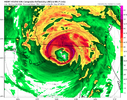
If you wanna see the worst case scenario for WNC and the upstate, the 18z HAFS-A model has you covered. Thankfully I think(hope) it is significantly overdone.
Meanwhile I just messaged a friend in Seneca and my family in Western Gaston County to have everything fully charged just in case.
Meanwhile I just messaged a friend in Seneca and my family in Western Gaston County to have everything fully charged just in case.
Brick Tamland
Member
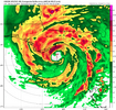
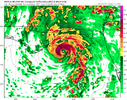
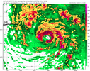
Wow, that's a big drop for a couple of them. And all of them showing a high end cat 3 to cat 4 now.18z landfall
HMON. 937.....was 943 in 12z
HAFS-A. 933.....was 969 in 12z
HAFS-B. 945.....was 967 in 12z
HWRF. 941.....was 943 in 12z
View attachment 151680
View attachment 151681
View attachment 151682
View attachment 151686
LovingGulfLows
Member
- Joined
- Jan 5, 2017
- Messages
- 1,297
- Reaction score
- 3,272
the cloud pattern from a IR image?
It has that curled up "shrimp" look based on IR. It just needs to have the remaining shear lessen on the Southern/Southwestern sides and have convection begin to blow up for it to close off completely and have a more classic tropical cyclone look.
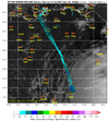
233330 1937N 08512W 6967 03084 9869 +171 +127 323019 031 /// /// 03 983 mb but probably at 986ish.
severestorm
Member
Got it. I can see that and the graphic SD posted.It has that curled up "shrimp" look based on IR. It just needs to have the remaining shear lessen on the Southern/Southwestern sides and have convection begin to blow up for it to close off completely and have a more classic tropical cyclone look.
That 3k run maxed out my wind gust scale
SUMMARY OF 800 PM EDT...0000 UTC...INFORMATION
----------------------------------------------
LOCATION...19.8N 85.3W
ABOUT 115 MI...185 KM ESE OF COZUMEL MEXICO
ABOUT 145 MI...235 KM S OF THE WESTERN TIP OF CUBA
MAXIMUM SUSTAINED WINDS...60 MPH...95 KM/H
PRESENT MOVEMENT...WNW OR 300 DEGREES AT 12 MPH...19 KM/H
MINIMUM CENTRAL PRESSURE...991 MB...29.26 INCHES
Up to 60 mph now
NEGaweather
Member
Sent from my iPhone using Tapatalk
rburrel2
Member
I know it’s just for fun, but I’m not sure I’ve ever seen the 3km NAM go below 885mb before. Wonder if there’s some theoretical max programmed in. Apparently not.
DustinWx
Moderator
I’ll be live streaming from coast. Leaving tomorrow night
dsaur
Member
Sent from my iPhone using Tapatalk
As long as it stays east of us. Seems like in the past there have been fewer clusters of spinners on the left side when the eye passes. I've still seen gusts near 100 from fast moving storms on this tract. Don't want twisters to add in, lol.

