• Hello, please take a minute to check out our awesome content, contributed by the wonderful members of our community. We hope you'll add your own thoughts and opinions by making a free account!

Tropical Hurricane Francine

210159_current_wind_sm.png
 
From Ryan Maue:

Model guidance is more confident in southern Gulf of Mexico disturbance rapidly intensifying into a hurricane prior to landfall in TX/LA Wed/Thurs

970s mb central pressure is quite significant, up to Category 2. Please keep an eye on (soon-to-be) Francine
 
Globals are still showing a central Louisiana landfall vrs the spaghetti models. Gonna be interesting to see who wins this one. I’m pulling towards the globals just because they been consistent with a strengthening storm up until landfall
 
The global models today have been concerning for me. GFS particularly shows the center of PTC 6 making landfall as a Cat 2/3 and then going inland just west of my location. A couple things to keep in mind that help me feel better is 1) We're still 3 days out, so the track and intensity forecast can and will change, and 2) this is just a couple of model runs of the operational GFS. All I can do is pray for the best and prepare for the worst, as the saying goes.
 
That’s still a powerful hurricane at 967mb. If this strengthens any faster than forecast then this could very well trend little more east as it feels the front l.
Yeah the stronger and more quickly deepening storm should go a bit further east
 
This is the first run with Six-06L 18z Euro and HAFS-A has a central Louisiana hit
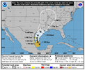
Probably why NHC forecast incorporates all the scenarios so far.

"The track guidance this cycle shifted east, with
the GFS and ECMWF models notably on the east side of the guidance
envelope. The initial NHC track forecast won't go quite that far
east, but splits the difference between the consensus aid TVCN and
these eastward model solutions. Future adjustments could be
necessary if these eastward trends continue. Given the current
structure, the track forecast is of lower confidence than usual."

213729_5day_cone_no_line_and_wind.png
 
NHC @ 11pm

“Little change in strength is expected during the next 12 to 24 hours as it will likely take some time for the system to consolidate and develop a well organized circulation. Once the system is able to
close off and contract, steady strengthening is forecast as the cyclone will be over warm waters and within a region of high moisture and upper-level diffluence. However, some of the models
show an increase in shear and slightly drier air affecting the system around the time it reaches the coast. The NHC intensity forecast is raised from the previous one and lies roughly near the
middle of the guidance envelope.

The highest winds are expected to remain on the west side of the system during the next day or so, but these winds should shift to the eastern side of the circulation before the cyclone reaches the Gulf Coast.”
 
0Z UKMET: lowest SLP (993) slightly higher than 12Z; similar landfall location and slightly earlier (late afternoon Wed 9/11; goes a little E of Memphis (slightly E of 12Z); then NE into KY:

NEW TROPICAL CYCLONE FORECAST TO DEVELOP AFTER 12 HOURS
FORECAST POSITION AT T+ 12 : 22.3N 93.8W

LEAD CENTRAL MAXIMUM WIND
VERIFYING TIME TIME POSITION PRESSURE (MB) SPEED (KNOTS)
-------------- ---- -------- ------------- -------------
1200UTC 09.09.2024 12 22.3N 93.8W 1004 35
0000UTC 10.09.2024 24 23.8N 94.9W 1003 34
1200UTC 10.09.2024 36 24.8N 95.2W 1000 37
0000UTC 11.09.2024 48 26.4N 94.0W 996 37
1200UTC 11.09.2024 60 28.5N 93.0W 993 45
0000UTC 12.09.2024 72 30.3N 90.9W 993 33
1200UTC 12.09.2024 84 32.8N 90.4W 995 24
0000UTC 13.09.2024 96 35.0N 90.0W 997 23
1200UTC 13.09.2024 108 35.6N 89.3W 1003 13
0000UTC 14.09.2024 120 36.7N 87.7W 1008 14
1200UTC 14.09.2024 132 CEASED TRACKING
 
NHC said this at 4am:

"official track forecast has again been nudged eastward in the 48-72
hour period, but not quite as far east as the ECMWF and corrected
consensus model predictions. It should be noted that confidence in
the track forecast is lower than normal since the system lacks a
well-defined center."


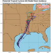
06L_tracks_latest.png.
 
I'm really curious to see what the new recon finds in a bit. Deep convection continues and increased banding is quite obvious in satellite imagery.

The ICON model which has been perhaps the most consistent with the evolution of this system has ticked eastward and puts SE Louisiana under the gun for a fairly significant hurricane.
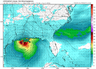
Yep...its a bit east of all guidance....

icon_mslp_wind_seus_fh57-57.gif
 
Per this, Francine is about to be designated:

AL, 06, 2024090912, , BEST, 0, 227N, 947W, 45, 1002, TS, 34, NEQ, 40, 100, 140, 140, 1008, 180, 70, 0, 0, L, 0, , 0, 0, FRANCINE, S, 0, , 0, 0, 0, 0, genesis-num, 014,
 
WTNT31 KNHC 091455
TCPAT1

BULLETIN
Tropical Storm Francine Advisory Number 4
NWS National Hurricane Center Miami FL AL062024
1000 AM CDT Mon Sep 09 2024

...DISTURBANCE BECOMES TROPICAL STORM FRANCINE...
...EXPECTED TO INTENSIFY WITH STORM SURGE AND HURRICANE WATCHES
ISSUED FOR THE LOUISIANA COAST...


SUMMARY OF 1000 AM CDT...1500 UTC...INFORMATION
-----------------------------------------------
LOCATION...23.0N 94.9W
ABOUT 245 MI...395 KM SE OF MOUTH OF THE RIO GRANDE
ABOUT 480 MI...770 KM SSW OF CAMERON LOUISIANA
MAXIMUM SUSTAINED WINDS...50 MPH...85 KM/H
PRESENT MOVEMENT...NNW OR 340 DEGREES AT 5 MPH...7 KM/H
MINIMUM CENTRAL PRESSURE...1002 MB...29.59 INCHES


WATCHES AND WARNINGS
--------------------
CHANGES WITH THIS ADVISORY:

A Storm Surge Watch has been issued from east of High Island,
Texas, eastward to the Mississippi/Alabama Border, including
Vermilion Bay, Lake Maurepas, and Lake Pontchartrain.

A Hurricane Watch has been issued from Cameron eastward to Grand
Isle in Louisiana.

A Tropical Storm Watch has been issued east of High Island, Texas,
to Cameron, Louisiana, and from Grand Isle, Louisiana, to the Mouth
of the Pearl River including Lake Pontchartrain and Lake Maurepas.


SUMMARY OF WATCHES AND WARNINGS IN EFFECT:

A Storm Surge Watch is in effect for...
* High Island Texas to the Mississippi/Alabama Border
* Vermilion Bay
* Lake Maurepas
* Lake Pontchartrain

A Hurricane Watch in in effect for...
* The Louisiana coast from Cameron eastward to Grand Isle

A Tropical Storm Watch is in effect for...
* Barra del Tordo to the Mouth of the Rio Grande
* Mouth of the Rio Grande to Port Mansfield
* East of High Island Texas to Cameron Louisiana
* West of Grand Isle to Mouth of the Pearl River
* Lake Pontchartrain
* Lake Maurepas
 
It will be interesting to see how far east the soon-to-be-issued hurricane warnings extend. I expect hurricane warnings to be as far east as Grand Isle and tropical storm warnings to the mouth of the Mississippi including Lake Ponchatrain.

Edit: Yes, I wrote this before seeing the 11 AM lol.
 
i think we've been really lucky in that a lot of hurricane landfalls the last few years have hit the part of louisiana where crocodiles outnumber humans 20-1
Alligators, but I get your point. This part of the Louisiana coast is a good spot to absorb landfall.
 
Back
Top