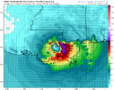
Definitely a very interesting look for tomorrow on the WRFs. Both get sbcape 1500-2000 across a thin region in central AL ahead of the tropical rain band.
-
Hello, please take a minute to check out our awesome content, contributed by the wonderful members of our community. We hope you'll add your own thoughts and opinions by making a free account!
You are using an out of date browser. It may not display this or other websites correctly.
You should upgrade or use an alternative browser.
You should upgrade or use an alternative browser.
Tropical Hurricane Francine
- Thread starter SD
- Start date
WILL BE VERY INTERESTING TO SEE WHAT UNFOLDS. NOT LOOKING AT ANYTHING MAJOR BUT A FEW SPINUPS DEF. POSSDefinitely a very interesting look for tomorrow on the WRFs. Both get sbcape 1500-2000 across a thin region in central AL ahead of the tropical rain band.
lexxnchloe
Member
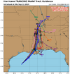
LOOKS TO ME AS IF THIS WILL HIT ON THE FAR EASTERN SIDE OF THE CONE..
It does look like it.LOOKS TO ME AS IF THIS WILL HIT ON THE FAR EASTERN SIDE OF THE CONE..
There is a fairly large area of near-hurricane-strength winds on the east side of the storm but nothing too crazy. Given the satellite presentation, I suspect the storm is near peak intensity. This storm reminds me a lot of Hurricane Edith in track and intensity from back in the 70s. Pretty much a garden variety storm for SE Louisiana.
Henry2326
Member
NoSnowATL
Member
She isn't special by any means but she's the 2024 type storm. Weak and eastside loaded and will end up being a nuisance more than anything.
Henry2326
Member
Especially a nuisance there if she drops a ton of water. They've closed the barriers on the canals if that gives you any indication. Where's the water gonna go but just pile up. I still remember those folks siting on their roofs.She isn't special by any means but she's the 2024 type storm. Weak and eastside loaded and will end up being a nuisance more than anything.
The flooding from Katrina wasn't from rain. The 17th Street and Industrial Canal floodwalls failed.Especially a nuisance there if she drops a ton of water. They've closed the barriers on the canals if that gives you any indication. Where's the water gonna go but just pile up. I still remember those folks siting on their roofs.
Francine is moving forward at a steady clip so any localized street flooding will be no worse than what happens frequently in summer downpours. Only areas outside of the flood control system need to be concerned about storm surge and that will be muted given the track from the SW.
Henry2326
Member
[
So they have mandatory evacuations for rainstorms? I don't think so. Mandatory evacuations started yesterday morning.The flooding from Katrina wasn't from rain. The 17th Street and Industrial Canal floodwalls failed.
Francine is moving forward at a steady clip so any localized street flooding will be no worse than what happens frequently in summer downpours. Only areas outside of the flood control system need to be concerned about storm surge and that will be muted given the track from the SW.
Those are all for low-lying areas outside of the flood control structures. All the usual places that happen whenever a storm approaches.[
So they have mandatory evacuations for rainstorms? I don't think so. Mandatory evacuations started yesterday morning.
Henry2326
Member
So they evacuate those places everytime a storm goes through??Those are all for low-lying areas outside of the flood control structures. All the usual places that happen whenever a storm approaches.
Last edited:
NoSnowATL
Member
Living in a fish bowl below sea level isn't a smart investment.Especially a nuisance there if she drops a ton of water. They've closed the barriers on the canals if that gives you any indication. Where's the water gonna go but just pile up. I still remember those folks siting on their roofs.
NoSnowATL
Member
storm chasers need to go there, it was be a fun ride.
Pretty much. It's just part of living on the water and marsh. Little towns such as Grand Isle have had seasons where multiple evacuation orders have been ordered.So they evacuate those places everytime a storm goes through??
Another thing that will be helpful to minimize surge east of the Mississippi River is with no strong HP NE of the system, there hasn't been a long period of 20+ mph easterly winds ahead of the storm to pile water into the sound and Lake Ponchartrain. On the other hand, the large eye will mean more areas than usual will get TS winds with gusts to near hurricane strength than one would expect with a cat 1/2 hurricane.
Looking at IR, outflow has definitely improved on the west side. The eastern movement will help with the westerly shear as well. I don’t necessarily think it will get there, but I wouldn’t be surprised to see a run at Cat 3.
NoSnowATL
Member
She's definitely acting like a women. Fighting to the very end.
The storm is putting up a strong fight against the westerly shear. Strong convection in the western eyewall and deep convection to the southwest out of radar range per satellite that we'll see if it can feed in and close off the eastern eyewall.


