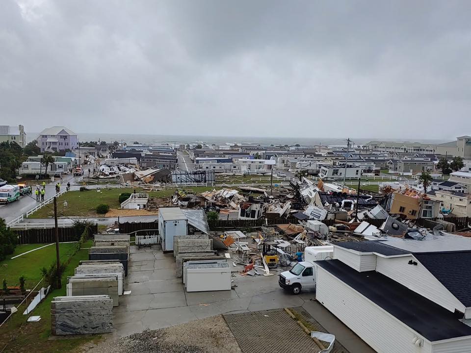
Tornado damage Emerald Isle
Yeah I just spoke to my buddy and he said it’s pretty bad. Wind is beating his house. Power has been out for hours. Debris everywhereI know someone in Charleston and he said conditions are pretty rough.
Me too....they say really intense right now. 2-3 hours more of it. High tide at 2:00 pm.I know someone in Charleston and he said conditions are pretty rough.
Supposedly thunder but yes bizarre was wondering same thingAnybody around Johnston county hear that rumbling just a min ago? Was that thunder? It went on for close to 20 seconds.

Hurricane Dorian Tropical Cyclone Update
NWS National Hurricane Center Miami FL AL052019
100 PM EDT Thu Sep 05 2019
...HURRICANE FORCE WIND GUSTS OCCURING IN CHARLESTON HARBOR...
Multiple observing stations located in and around Charleston Harbor
have reported wind gusts of 75-80 mph (120-129 km/h) within the last
hour.
A Weatherflow site in Winyah Bay, SC recently reported a wind gust
of 86 mph (138 km/h) at a height of 50 ft.
SUMMARY OF 100 PM EDT...1700 UTC...INFORMATION
----------------------------------------------
LOCATION...32.7N 79.0W
ABOUT 55 MI...90 KM E OF CHARLESTON SOUTH CAROLINA
ABOUT 125 MI...200 KM SSW OF WILMINGTON NORTH CAROLINA
MAXIMUM SUSTAINED WINDS...110 MPH...175 KM/H
PRESENT MOVEMENT...NNE OR 20 DEGREES AT 8 MPH...13 KM/H
MINIMUM CENTRAL PRESSURE...958 MB...28.29 INCHES
Supposedly thunder but yes bizarre was wondering same thing
It’ll fizzle out like a fart in the wind once it gets above 40NI agree with Ryan on Twitter, this could be catastrophic for Canada.

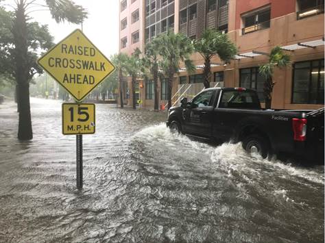
High tide at 2:00 pmCharleston. Not too terrible yet
EURO just came in with a bomb. May test sub 940mb.It’ll fizzle out like a fart in the wind once it gets above 40N
.png")
These two are certainly visibleLocal TV stations in Wilmington are so busy talking about the tornado warnings that they haven't been able to report on where Dorian is heading.

Seems there is less traffic on the thread today. I thought it would be busier now that Dorian is actually on the doorstep and with the tornado threat.
Worst of the weather (aside from tornado threat) to hit this evening with eye approaching and sting jet that models are depicting over eastern NC. I expect people need to take a bit of a pause before the triple threat onslaught. HRRR showing convective elements covering much of NC from Triangle eastward to Pamlico Sound starting this evening.
Almost every model has the wind maximum showing up in Eastern NC now. Obviously some are over done but could certainly be an issue tonight into tomorrow morning. Location is still up in the air depending on where the storm ends up
View attachment 23217

Im swamped at work..I hate I am missing itMaybe so. I was afraid everyone was so burned out from tracking Dorian that they are done talking about it now that it is here.
I'm sure that is part of it too. But since it didn't get to 80.001 degrees west the threat is goneMaybe so. I was afraid everyone was so burned out from tracking Dorian that they are done talking about it now that it is here.
") . It will pick up when people get off work. A lot of people are trying to get things wrapped up in case there are outages or preparing.
. It will pick up when people get off work. A lot of people are trying to get things wrapped up in case there are outages or preparing.SUMMARY OF 200 PM EDT...1800 UTC...INFORMATION
----------------------------------------------
LOCATION...32.8N 78.9W
ABOUT 60 MI...95 KM S OF MYRTLE BEACH SOUTH CAROLINA
ABOUT 115 MI...185 KM SSW OF WILMINGTON NORTH CAROLINA
MAXIMUM SUSTAINED WINDS...110 MPH...175 KM/H
PRESENT MOVEMENT...NNE OR 25 DEGREES AT 8 MPH...13 KM/H
MINIMUM CENTRAL PRESSURE...958 MB...28.29 INCHES
We're getting more rain than I thought.I'm sure that is part of it too. But since it didn't get to 80.001 degrees west the threat is gone
Probably a wobble, NHC still has NNE as of 2 pm. I thought it had turned NE earlier and it wobbled back, smooth those out and still on a NNE heading. Recon is currently in there though, so if it has moved east of north more we will know soonLast few frames of my radar looks like he is moving east
Probably a wobble, NHC still has NNE as of 2 pm. I thought it had turned NE earlier and it wobbled back, smooth those out and still on a NNE heading. Recon is currently in there though, so if it has moved east of north more we will know soon
Yeah I tend to agree with this, also of note if I'm not mistaken he is already further NW then any of today's model runs showed..... which is why I basically have quit looking at them. Just monitor radar now but I'm afraid ILM is going to get rockedGonna have to have more east wobble than north wobbles if he is going to stay on or east of the NHC track, once he speeds up the wobbling will smooth out and I think the more inland track Cape Fear/MHX/Hatteras is likely if it doesnt make a good east turn in the next 4-5 hrs....