6z eps with the northern turn very similar to matthew. slooooowly crawls up the fl coast towards the SE.
-
Hello, please take a minute to check out our awesome content, contributed by the wonderful members of our community. We hope you'll add your own thoughts and opinions by making a free account!
You are using an out of date browser. It may not display this or other websites correctly.
You should upgrade or use an alternative browser.
You should upgrade or use an alternative browser.
Tropical Hurricane Dorian
- Thread starter RBR71
- Start date

Ethan80963!
Member


B
Brick Tamland
Guest
That does not look good for us north of Florida. Should have known anything more than 72 hours out is going to change.
And scary thing is if it does not go west into Florida and has more time over water, it could just become even stronger for where it eventually does hit.
JaxHurricane12
Member
I strangely am getting a feeling that this will end up being something similar to how Matthew was.
whats interesting, and we will have to keep an eye on this, but notice how toward the end (on this map time frame) how they are bending back toward the NW toward the coastline.
Henry2326
Member
Matthew......as the storm looks for a weakness in the ridge....


B
Brick Tamland
Guest
But then this screams a Florida hit, and looks like more and more getting to a cat 3.
You can see the w-ar keeping Dorian south and west but then it weakens and another w-ar build back west. There will be an alley it looks like with a big low in SE Canada. The ridge in the west seems really stout.
I know DT already said Dorian isn't coming north and risk to the SE (GA/SC/NC) is over played but not sure how he can say that yet. I still thinks this hits Florida unfortunately.
I wonder how many hurricanes have hit the SE with a big low in SE Canada like that.

I know DT already said Dorian isn't coming north and risk to the SE (GA/SC/NC) is over played but not sure how he can say that yet. I still thinks this hits Florida unfortunately.
I wonder how many hurricanes have hit the SE with a big low in SE Canada like that.
241
URNT12 KWBC 291342
VORTEX DATA MESSAGE AL052019
A. 29/13:02:57Z
B. 21.12 deg N 066.99 deg W
C. 700 MB 3005 m
D. 987 mb
E. 105 deg 09 kt
F. CLOSED
G. C5
H. 51 kt
I. 209 deg 3 nm 13:02:16Z
J. 271 deg 55 kt
K. 211 deg 16 nm 12:59:24Z
L. 77 kt
M. 040 deg 38 nm 13:12:10Z
N. 129 deg 64 kt
O. 019 deg 8 nm 13:05:00Z
P. 11 C / 3045 m
Q. 15 C / 3026 m
R. 6 C / NA
S. 12345 / 7
T. 0.01 / 1 nm
U. NOAA2 1305A DORIAN OB 06
MAX FL WIND 64 KT 019 / 8 NM 13:05:00Z
Saw on WU:
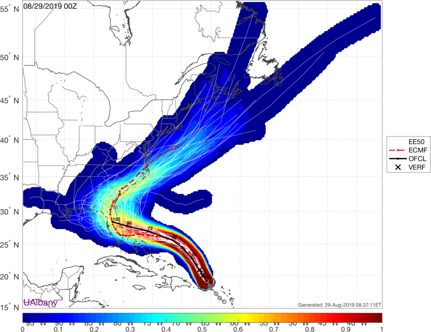
Euro and GFS Ensemble track density “Heat Maps”:

Euro and GFS Ensemble track density “Heat Maps”:
accu35
Member
I'll check in from time to time today on Dorian, my dad is having heart surgery. Say a prayer.
NC and SC folks definitely not out of the woods yet with this one:

I’ll make a guess and say the ridge out west trends back further in that direction and the one in the Atlantic comes in stronger. Florida landfall between Jacksonville and Palm Bay. If following hurricanes the past 3 years has taught me anything it’s that modeling is rather useless at this stage in the game. It’s all a guess
231
URNT15 KWBC 291410
NOAA2 1305A DORIAN HDOB 26 20190829
140100 2130N 06719W 6960 03167 0043 +097 //// 045035 041 047 012 01
140130 2129N 06718W 6907 03220 0028 +098 //// 062042 045 048 012 01
140200 2127N 06716W 6957 03155 0022 +100 //// 052039 040 050 011 01
140230 2126N 06714W 6996 03101 0007 +106 +104 045040 042 053 008 00
140300 2125N 06713W 6957 03130 9988 +108 +084 049044 045 053 002 00
140330 2123N 06711W 6967 03103 9965 +111 +107 045048 048 053 006 00
140400 2122N 06709W 6949 03099 9920 +124 +108 040049 051 059 008 00
140430 2121N 06708W 6951 03075 9892 +125 +115 041032 036 047 009 00
140500 2119N 06706W 6971 03040 9872 +137 +101 096006 008 027 005 03
140530 2117N 06706W 6978 03032 9860 +146 +096 211011 017 027 001 00
140600 2115N 06706W 6964 03062 9882 +136 +115 254035 049 044 005 00
140630 2113N 06706W 6996 03055 9936 +122 +114 256053 057 052 008 00
140700 2111N 06705W 6971 03102 9979 +109 +101 254051 052 053 008 03
140730 2110N 06704W 6968 03124 9994 +109 +085 253047 050 045 001 00
140800 2108N 06702W 6949 03159 0010 +103 +097 240049 057 043 005 00
140830 2107N 06700W 6968 03144 0021 +108 +074 237058 062 043 005 00
140900 2105N 06659W 6967 03156 0027 +112 +055 237063 064 044 006 00
140930 2104N 06657W 6963 03164 0027 +119 +054 239061 063 046 005 00
141000 2102N 06655W 6971 03157 0047 +107 +058 248060 061 046 004 00
141030 2101N 06654W 6967 03174 0068 +095 +058 248056 057 046 004 00
Second pass has the pressure down to 986 mb.
also look how the outflow is improving especially on west side. Hurricane is expanding more on west side more.
NWMSGuy
Member
So if the western ridge is stronger and the storm slower and stalls this thing is going Westward? Just thinking of this being in the Gulf for an extended amount of time is scary.Just a note, although the Euro turns up FL on this run, it is actually closer to going much farther west. Troughing over the NE is much weaker and ridging over the top and stronger and that western ridge center is farther east. Dorian is slower still and is getting very close to stalling and getting caught under the western ridge and going to see Brent. Haha.
It really looks like this,
Faster= FL into GOM into northern gulf coast
Slow= FL hit, stall into GA
Slower= FL hit, stall, west into GOM, possible west gulf coast hit.
Another key thing will be the ULL thats moving WEST and SW ahead of Dorian will be key on where it "tugs" the hurricane.
Ethan80963!
Member

South AL Wx
Member
Winds up to 85 mph at the 11:00 update
Winds have been at 85 mph since the 11 pm advisory last night.
South AL Wx
Member
The 11 am advisory now has Dorian reaching a peak intensity of 130 mph, category 4.
Pressure down to 986 mb.SUMMARY OF 1100 AM AST...1500 UTC...INFORMATION
-----------------------------------------------
LOCATION...21.4N 67.2W
ABOUT 220 MI...355 KM NNW OF SAN JUAN PUERTO RICO
ABOUT 370 MI...600 KM E OF THE SOUTHEASTERN BAHAMAS
MAXIMUM SUSTAINED WINDS...85 MPH...140 KM/H
PRESENT MOVEMENT...NW OR 325 DEGREES AT 13 MPH...20 KM/H
MINIMUM CENTRAL PRESSURE...986 MB...29.12 INCHES
New intensity forecast has it up to 130 mph.
INIT 29/1500Z 21.4N 67.2W 75 KT 85 MPH
12H 30/0000Z 22.9N 68.1W 85 KT 100 MPH
24H 30/1200Z 24.5N 69.6W 100 KT 115 MPH
36H 31/0000Z 25.6N 71.4W 105 KT 120 MPH
48H 31/1200Z 26.3N 73.4W 110 KT 125 MPH
72H 01/1200Z 27.0N 76.9W 115 KT 130 MPH
96H 02/1200Z 27.5N 79.8W 115 KT 130 MPH
120H 03/1200Z 28.1N 81.5W 65 KT 75 MPH...INLAND
Ethan80963!
Member
Oops haven't seen the past few updatesWinds have been at 85 mph since the 11 pm advisory last night.
SCWXGuy
Member
Looks like the 11am NHC update shifted slightly south. They don't seem to be giving any credence to any potential weakness in the ridge and being remarkably consistent. Am I the only one that has seen these get pulled north too many times not to be at least a little skeptical of this setup?
Last edited:
pcbjr
Member
A little tad south and slightly slower. This is a difficult set up and as much as anyone can "guess" or "read" models, I for one am going with official (which I strongly suspect will shift north and perhaps somewhat east over the next 24 hours).Looks like the 11am NHC update shifted slightly south. They don't seem to be giving any credence to any potential weakness in the ridge and being remarkably consistent. Am I the only one that has seen these get pulled north too many times not to be skeptical of this setup?
B
Brick Tamland
Guest
Looks like the 11am NHC update shifted slightly south. They don't seem to be giving any credence to any potential weakness in the ridge and being remarkably consistent. Am I the only one that has seen these get pulled north too many times not to be at least a little skeptical of this setup?
NHC doesn't seem to be buying this going north at all. They have been pretty consistent with the track into Florida.
packfan98
Moderator
The NHC always adjusts gradually. The biggest adjustment is the slower movement. I think that's why you don't get to see the potential north turn on their latest graphic. Give it another day and you will be able to see their thoughts about movement after landfall. Unfortunately, it looks to move very slowly as it approaches land.Looks like the 11am NHC update shifted slightly south. They don't seem to be giving any credence to any potential weakness in the ridge and being remarkably consistent. Am I the only one that has seen these get pulled north too many times not to be skeptical of this setup?
Henry2326
Member
Lol....so you are really saying, "going with them today because they will change it"....I'm with ya.A little tad south and slightly slower. This is a difficult set up and as much as anyone can "guess" or "read" models, I for one am going with official (which I strongly suspect will shift north and perhaps somewhat east over the next 24 hours).
")
SCWXGuy
Member
The NHC always adjusts gradually. The biggest adjustment is the slower movement. I think that's why you don't get to see the potential north turn on their latest graphic. Give it another day and you will be able to see their thoughts about movement after landfall. Unfortunately, it looks to move very slowly as it approaches land.
I'm not thinking of the scenario where it turns north after landfall, as the north turn will happen at some point. I'm thinking of the scenario where it comes up the east coast and grazes or even misses FL. We wait and see. I guess I have been expecting more slight adjustments north rather than south or unchanged.
Henry2326
Member
Actually the last 2 points on the chart are more like the Euro 00z....The NHC always adjusts gradually. The biggest adjustment is the slower movement. I think that's why you don't get to see the potential north turn on their latest graphic. Give it another day and you will be able to see their thoughts about movement after landfall. Unfortunately, it looks to move very slowly as it approaches land.
packfan98
Moderator
Gotcha. The last position on the map is right in the middle of the state of FL approximately 100 miles inland. A shift of 100 miles to the east will get the coastal scraper you are talking about. It's well within the cone of uncertainty.I'm not thinking of the scenario where it turns north after landfall, as the north turn will happen at some point. I'm thinking of the scenario where it comes up the east coast and grazes or even misses FL. We wait and see. I guess I have been expecting more slight adjustments north rather than south or unchanged.
pcbjr
Member
No, I'm saying I'm going with official, and if they change it, as I suspect, I'll go with the change. They have tools we don't ....Lol....so you are really saying, "going with them today because they will change it"....I'm with ya.
Last edited:
The NHC are using internal forecasting tools that are much better at blending the modeling, handling biases, and h500 than what we can. If you see a substantial shift in their track, it's because those tools, using trends from operational and ensembles, will begin to catch on usually after we see the trend begin on the operational runs.
Plus those guys are pretty smart too, and don't want to swing their cone back and forth too much per model run.
Plus those guys are pretty smart too, and don't want to swing their cone back and forth too much per model run.
ICON is actually a touch north
Ethan80963!
Member

NBAcentel
Member
Looks like it sped up vs it being more north
ICON slows down right at the coast it would appear
ICON seems to be initiallizing Dorian too weak. It doesn't show the current pressure forecasted until mid morning Saturday!
Sent from my SM-G950U using Tapatalk
Sent from my SM-G950U using Tapatalk
Kind of unrelated but just curious, anybody remember how far out (in terms of days) we were when the forecast for Florence last year decided to stall near the coast and head west through Wilmington instead of a northwest strike through the Piedmont?