• Hello, please take a minute to check out our awesome content, contributed by the wonderful members of our community. We hope you'll add your own thoughts and opinions by making a free account!

Pattern Hotober

NorthDFWwx

Pureblood
Member
Joined
Dec 9, 2018
Messages
3,483
Reaction score
5,547
Location
Plano, TX
I almost did this yesterday, and decided against it.

But I can't help myself. :p

WK34temp.gif
 
well merry Christmas since everything comes early now it seems I see eye roll what I dong dong dong dong
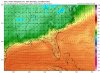
 
I went and analyzed the lastest model runs temperature plots. 00z Euro/CMC data 06z GFS data.
This is for KGSO PTI airport
The warmth looks consolidated all the way through the end of the month.
Though October looks to cool down considerably
GSO model temperature.PNG
If you would like to purchase this graphic or others like it, contact me at
[email protected]
 
Looks like as we roll into October we will start to at least see the ridge get beat back some and maybe try to shift more toward the plains probably still above normal though. Week 2 of the month may be the time to actually cool to near normal and get some rain chances into the region

Sent from my SM-G975U using Tapatalk
 
So far the lack of fall fronts hasn't been an issue for me, since I'm down on the Gulf coast. We usually start getting legit cold fronts in the first 2 weeks of October. But it's the intensity and steadfastness of the heat this late in the year that's been unreal. By now the highs should be dipping down to the 80s at times, not unrelenting lower to upper 90s EVERY SINGLE DAY.

Sent from my SM-G950U using Tapatalk
 
Living up to its name! 2BC2958E-6A99-47CE-8EF5-F9BAE8EB286D.png
 
Normal high is 79
 
The front next week looks good so far. Gfs has been showing this cool down next week for a few days now. This 18z happy hour run is by far the coldest.
 
The front next week looks good so far. Gfs has been showing this cool down next week for a few days now. This 18z happy hour run is by far the coldest.
It’ll be 20+ degrees warmer come verification time! Welcome to fall and winter, and the sucky gfs
 
Too bad it's the GFS, though all around an awesome run. Doesn't get above average from the 4th onwards
 
There may be hope for october...
The Heatwave Of September 20, 1925
Posted on September 20, 2016 by tonyheller
On this date in 1925, most of the Southeastern US was over 100 degrees, with Georgia reaching 107 degrees. Almost half of the US was over 90 degrees. "
Apparently the heat began early in September when centerville al reached a record of 112 degrees, birmingham was 106, Sept 5 1925.
6 days in a row had 102 or hotter starting on September 3.* 12 days had 100 or hotter in September alone and 2 in August.
After the record breaking hot September in 1925, October 1925 produced record cold and snow over much of the country. -30 F temperatures in Montana and near 0 F in Iowa. In DC, the coldest and snowiest October on record.

Then a record late season hurricane hit from FL to NC in early December.


1569200540045.png
 
Last edited:
Head can’t take talking in future tense swirling now. Karen here huh pumpkin spice stop right now
 
Last 24 hours of model runs...the good, the bad, and the ugly. Cold coming then not but maybe more rain?


Sent from my iPhone using Tapatalk
 
Last 24 hours of model runs...the good, the bad, and the ugly. Cold coming then not but maybe more rain?


Sent from my iPhone using Tapatalk

Despite the GFS (not unexpectedly) backing off on the cold front passage next week, it does have a nice treat at the very end of its run.
 
For what it’s worth at hour 240 12z GFS, we have a better cold press.


Sent from my iPhone using Tapatalk
 
Rapidly losing its punch and moisture as it get to Georgia...probably a dry wedge event coming.


Sent from my iPhone using Tapatalk
 
Back
Top