Grok says:
Based on the latest forecasts from NOAA's Climate Prediction Center, ECMWF, GFS ensembles, and expert analyses (including from MIT's Judah Cohen and AccuWeather), the eastern US is unlikely to see a sustained warm-up in mid-December 2025. Instead, the signal points to persistent below-average temperatures and heightened storm activity, driven by a major disruption to the polar vortex from an ongoing sudden stratospheric warming (SSW) event. This is one of the earliest and strongest SSW signals on record, which has a track record of propagating downward to deliver repeated Arctic air outbreaks across the central and eastern US during December.
Key Forecast Details for Mid-December (Roughly Dec 10–20)
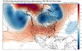
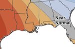
- Temperature Outlook: Models consistently show a deep trough (low-pressure pattern) anchored over the eastern US, pulling frigid Canadian air southward. Highs in the 20s–30s°F are likely from the Midwest to the Northeast, with lows dipping into the teens or single digits in many spots—5–15°F below normal. The Southeast may hover near normal (30s–40s°F highs), but no widespread warmup is evident. NOAA's seasonal map favors above-normal temps only along the immediate Gulf Coast and South, not extending northward into the core eastern regions.
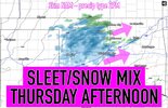
- Precipitation and Storms: An active pattern with multiple clipper systems and coastal lows will bring rounds of snow, sleet, and ice, especially in the Appalachians, Mid-Atlantic, and interior Northeast. Accumulations of 3–6+ inches are possible in favored upslope areas (e.g., western PA to southern NY) during 1–2 events. The Great Lakes could see lake-effect snow totals exceeding 1–2 feet by mid-month.
- Broader December Context: Early December (first 7–10 days) starts chilly but builds to the peak cold around the third week. A potential holiday Arctic blast could follow, echoing patterns like December 2000 (one of the coldest on record). Overall, December leans 3–5°F below normal east of the Rockies, with above-normal snowfall in the Midwest, Ohio Valley, and Northeast.
Is This a "Fake" Signal in the Models?
No—this appears to be a robust, high-confidence signal rather than noise or an outlier. Here's why, based on multi-model consensus and atmospheric drivers:
- Model Agreement: The ECMWF, GFS, and Canadian ensembles (as of Dec 2 runs) align on the trough and cold anomalies, with ensemble spreads tightening (less uncertainty). Earlier runs showed some mild wobbles, but the SSW's influence has locked in the cold bias. Judah Cohen's AI subseasonal model specifically flags the "most expansive region of extreme cold" stretching from the Canadian Plains to the East Coast in the third week.
- Key Drivers:
- SSW/Polar Vortex Disruption: A vortex split or weakening (already underway in the stratosphere) often delays recovery for weeks, funneling cold air equatorward. Historical SSW events (e.g., 2010, 2018) led to 70–80% of Decembers being colder-than-average in the eastern US.
- Teleconnections: Negative Arctic Oscillation (AO) and North Atlantic Oscillation (NAO) phases—both favored through mid-December—reinforce high-latitude blocking, trapping cold over North America. La Niña (weak but persistent) adds a trough-favoring jet stream dip over the East.
- MJO Influence: The Madden-Julian Oscillation is stalling in phases (6–8) that suppress ridging (warmth) over the eastern US while boosting cold outbreaks.
- Caveats and Reliability: Subseasonal forecasts (2–4 weeks) have ~60–70% skill for patterns like this, per NOAA. A brief 2–3 day thaw can't be ruled out if a single ridge sneaks in, but the overall trend resists warming until late December or January (when La Niña weakens). If models flip (e.g., due to MJO speedup), we'd see it by Dec 5–7 runs—monitor those.
| Region | Mid-Dec Temp Anomaly | Snow Potential | Confidence |
|---|
| Northeast (NY/PA/NE) | -5 to -10°F | High (multiple events) | High |
| Mid-Atlantic (DC/VA) | -3 to -7°F | Medium (mix/snow north) | Medium-High |
| Southeast (Carolinas/GA) | Near normal | Low (rain dominant) | Medium |
| Midwest/Ohio Valley | -7 to -12°F | High (clippers/lake-effect) | High |
For real-time updates, check NOAA's Weather Prediction Center or apps like Weather Underground. If you're in the East, prep for winter—shovels over swimsuits this month.


