Negative Ghost RiderBrier Creek?
-
Hello, please take a minute to check out our awesome content, contributed by the wonderful members of our community. We hope you'll add your own thoughts and opinions by making a free account!
You are using an out of date browser. It may not display this or other websites correctly.
You should upgrade or use an alternative browser.
You should upgrade or use an alternative browser.
Misc General Banter Thread
- Thread starter Rain Cold
- Start date
Ward Cleaver
Member
I wish the female, millennial weather broadcasters would learn to pronounce the T in the word mountains. You don't have to over-annunciate the T, but it's not pronounced mao-uuuhns. 
I'm far from one to complain and moan, but I'm hoping things pick up from an intensity (although, I've had moderate snow off and on) and rates purpose or else this feels "meh."Not sure about Mitch but here in West Columbia which is in same county as Mitch it’s been a dud so far. Snowing since 8 this morning. Tiny flakes with very little accumulation. Almost looks like sun wants to come out now
This storm currently (I'm gonna use the word "currently") feels like the one from last January where it snowed pixie flakes for about 8 or 9 hours, and I only ended up with 1.5-2 inches. I'm awaiting to see what later this afternoon and evening has to offer.
With that said, it's still beautiful to watch and we could be getting blanked (both are positives).
I grew up watching Mid Atlantic Championship Wrestling on WRAL and Georgia Championship Wrestling on WTBS. Those were the days that wrestling was real to me.Going to watch the royal rumble this afternoon so I can feel better knowing that there are millions of other bozos believing in things that aren't real
blueheronNC
Member
SWVAwxfan
Member
Up to 6" now. Still pouring down hard.
I wish the female, millennial weather broadcasters would learn to pronounce the T in the word mountains. You don't have to over-annunciate the T, but it's not pronounced mao-uuuhns.
That's a regional dialect thing, not a millennial thing.
Brick in panic mode , is awesome!
He’s in his John Cena pj’s
He’s in his John Cena pj’s
Ward Cleaver
Member
No. It's called T-glottalization and it's well studied by linguists. It grew beyond solely a regional dialect and expanded due to the internet especially among younger females.That's a regional dialect thing, not a millennial thing.
SWVAwxfan
Member
This board will explode if Raleigh gets blanked. I do not expect that to happen though
blueheels2
Member
I’m in the Triangle and I have come to grips with we will get nothing. It’s hilarious if you think about it.
SWVAwxfan
Member
Also happened in Cola back in the late 2010s. Big winter storm that radar showed blue all over the midlands fir hours. Cola got a few flurries.Yeh man, it's the worst IMO. We had that here in Cola with last years snow event. I am sure it adds up quick when you can fully saturated the column, but man we had that for like 12 hours straight here in SC last Winter with the Gulf storm & it added up to a wopping 0.9 of an inch.
Big Frosty probably already at 10”
No. It's called T-glottalization and it's well studied by linguists. It grew beyond solely a regional dialect and expanded due to the internet especially among younger females.
Sort of. The broadcast journalism programs where young people learn the "news voice" are heavily populated with that and other vocal irregularities. The women especially are pushed to lower their voices as higher tones are too often mis-interpreted as shrill. I've known quite a few on camera folks over the years including current young ones and they all sound what I'd call normal off camera with whatever natural dialect they have.
I don't hear the T dropped in the middle of words until I get well up into Ohio. That's a little different than us southerners slurring our way around the English language.
Is WBTV Charlotte really showing the Utah St vs San Diego St basketball game during an historic snowstorm in Charlotte? Come on now..!! For some reason it doesn’t feel like they are truly “on your side” atm! 
Last edited:
I am from Atlanta originally and my personal record for snowfall is 5” (last year actually). We are about to blow this out of the water - this is actually surreal to see play out in real life vs. the pretty colors on the models
BrickTamland
Member
Really feels like the mets have no idea what's going to happen with winter storm threats here until it happens. Some folks getting a lot more snow than was expected and forecasted while others get nothing. The best they can do is look at the HRRR and 3K NAM 12 hours out and make a guess based.on what they show.
blueheronNC
Member
Dry slot looks wider south of the Triangle and will likely move back in after these 15 minutes of flurries.
HurricaneSolomon
Member
- Joined
- Dec 6, 2021
- Messages
- 154
- Reaction score
- 276
Brier Creek?
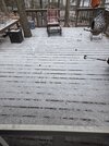
Close to there yes! Still coming down. Small flakes but they have gotten slightly bigger.
Sent from my iPad using Tapatalk
The way it’s been snowing today idk how there isn’t a foot on the ground out here. Zero lull’s. It’s one big death band
I'm not really seeing that. What I see on future casts are though is the coastal not backing-in with precip. We're just getting the ULLDry slot looks wider south of the Triangle and will likely move back in after these 15 minutes of flurries.
HurricaneSolomon
Member
- Joined
- Dec 6, 2021
- Messages
- 154
- Reaction score
- 276
The NWS had just backed off of those totals. Now they are calling for two to five inches. The no snow slot is slowly filling in on radar.
I saw that. Usually if they’re confident in that they’ll update the warning to show it.
Sent from my iPad using Tapatalk
Although we aren't going to score like GSP or CLT, I feel better about our chances in the Raleigh area to get a couple of inches. Better than a complete shutout like December 2000 or January 2011, I guess.
Maybe but we will not see a set up like this again for perhaps a long time. Super cold on both ends of the eventAlthough we aren't going to score like GSP or CLT, I feel better about our chances in the Raleigh area to get a couple of inches. Better than a complete shutout like December 2000 or January 2011, I guess.
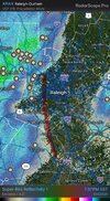
On Radar Scope there appears to be a huge dry slot to our south moving due north. Don’t see how that wouldn’t negatively affect snowfall in the triangle. Seems our only hope is when the ULL moves out later tonight to pick up and inch or two.I'm not really seeing that. What I see on future casts are though is the coastal not backing-in with precip. We're just getting the ULL
Snowflowxxl
Member
They are paid to do more than just look at a couple models. They need to be held accountable for these last two weeks.Really feels like the mets have no idea what's going to happen with winter storm threats here until it happens. Some folks getting a lot more snow than was expected and forecasted while others get nothing. The best they can do is look at the HRRR and 3K NAM 12 hours out and make a guess based.on what they show.
I'm far from one to complain and moan, but I'm hoping things pick up from an intensity (although, I've had moderate snow off and on) and rates purpose or else this feels "meh."
This storm currently (I'm gonna use the word "currently") feels like the one from last January where it snowed pixie flakes for about 8 or 9 hours, and I only ended up with 1.5-2 inches. I'm awaiting to see what later this afternoon and evening has to offer.
With that said, it's still beautiful to watch and we could be getting blanked (both are positives).
I’m in Lexington just off I20 and we’re getting covered here!! Been snowing at a moderate rate for a while now
Sent from my iPhone using Tapatalk
This hook area you mean below correct? What is just off to the west looks to be moving S->N and not building east so makes sense right now I supposeOn Radar Scope there appears to be a huge dry slot to our south moving due north. Don’t see how that wouldn’t negatively affect snowfall in the triangle. Seems our only hope is when the ULL moves out later tonight to pick up and inch or two.
IR looks terrible, rapidly cooling cloud tops east of 95, warming tops between us1 and 95. I'm so sad dude. There's no coming back from this
RollTide18
Member
The sun coming completely out after morning snow is the equivalent of post *** clarity
olhausen
Member
Believe me you want none of what people got north of you from last weekendSo far everyone from north south west and now east of me has gotten snow yet around these parts here in the tennessee valley we have gotten nothing. only thing so far this winter we got was a bone chilly cold rain and maybe a flurry smdh
Yeah that was the area I was referring to. Seems some models have that area filling in later this evening but the way things have been going I find it hard to believe. Fingers crossed we get a miracleThis hook area you mean below correct? What is just off to the west looks to be moving S->N and not building east so makes sense right now I suppose
View attachment 192728
NCPROGRAMMER
Member
Models have been trying to fill in that area all day. Not happening.Yeah that was the area I was referring to. Seems some models have that area filling in later this evening but the way things have been going I find it hard to believe. Fingers crossed we get a miracle
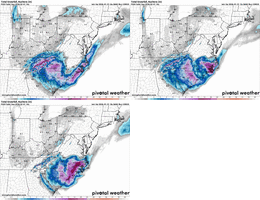
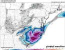
The 12km NAM isn’t a serious model…they shouldn’t even run that anymore. They should just unplug it.Almost a foot left to goView attachment 192746
I see your optimistic…Raleigh might get measurable snow by 2100. Absolutely beyond pathetic. How’s the job market in New England?

