Given the big game up in Boone, the SPC already introducing a Marginal Risk 3 days out for severe, trick or treaters along the road, fall color leaves falling, etc. Post your rain totals, gusts, any mountains winter weather, temp swings, goblin sightings, severe weather and loss of fall color leaves here as all could occur.
-
Hello, please take a minute to check out our awesome content, contributed by the wonderful members of our community. We hope you'll add your own thoughts and opinions by making a free account!
You are using an out of date browser. It may not display this or other websites correctly.
You should upgrade or use an alternative browser.
You should upgrade or use an alternative browser.
Observations Fright Night Halloween Week Severe Obs
- Thread starter BirdManDoomW
- Start date
-
- Tags
- boo
Per SPC, no upgrade until a better handle of instability is realized if any. Strong damaging winds within a line is the current threat. 
Per Brad Pan. 
NBAcentel
Member
Good thread birdman, if both NAMs are correct, which they have a tendency to overdo instability, it wouldn’t shock me to see a slight or even a enhanced
And timing which keeps changing to what I think is for more severe now.Good thread birdman, if both NAMs are correct, which they have a tendency to overdo instability, it wouldn’t shock me to see a slight or even a enhanced
S
snowcool776
Guest
So, this means that we will have probably an Enhanced risk for severe weather?
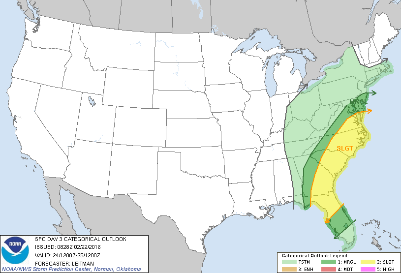
This was day 3 in the 2016 tornado outbreak
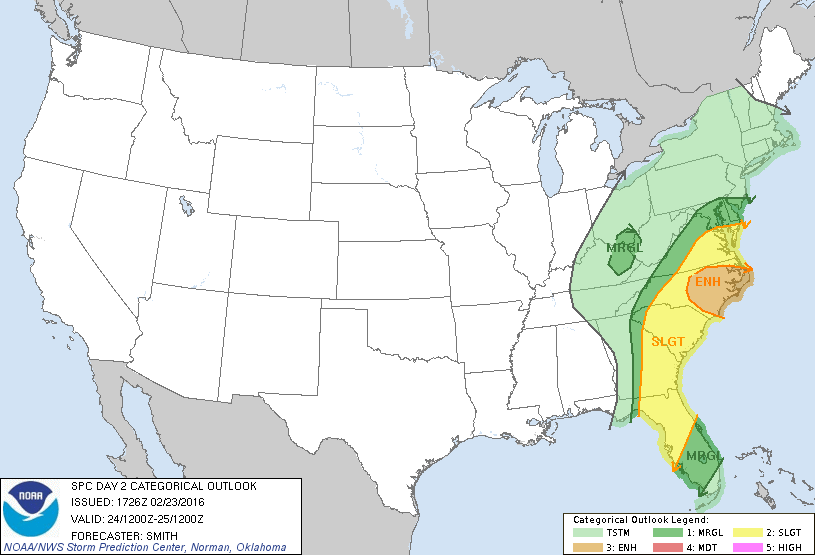
This was day 2 in the 20160224 tornado outbreak
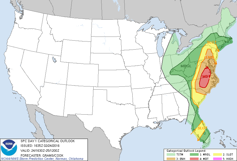
And this was day 1 in the outbreak.
Seems to be they are slapping the lowest risk, only to be upgraded every day until day 1.
This was day 3 in the 2016 tornado outbreak
This was day 2 in the 20160224 tornado outbreak
And this was day 1 in the outbreak.
Seems to be they are slapping the lowest risk, only to be upgraded every day until day 1.
Z
Zander98al
Guest
Simulated radar and parameters arent too shabby in alabama for wensday and thursday for severe weather. With 2 waves maybe??

My analysis part 1. I think the NAM is growing increasingly severe for the central piedmont west into the foothills and mtns of NC and extreme north-western SC. Orange is noted for the heavy squall line but don’t be fooled as precip starts to favor Virginia over Raleigh area south. More on this with part 2 analysis. Purple is activity breaking out front that needs to be watched as it moves moves north-East. Note again not a due east movement which will severely hurt eastern NC’s rainfall department. Moreover, Saturation will occur in the NC mtns before even more rain and wind hits with the main line. I smell a flood threat (Watauga, Ashe, Allegheny) given the strong upslope shown in the yellow line. These areas could approach a foot of rain for October given recent rain events going over 4”. I’m worried High Wind Warnings will need to be stated for the ground being very saturated despite being in a drought* (Thursday update should show improvement however). Circled the GOM black as there is little to no disruption of moisture to stop what’s coming namely for western NC. 
Last edited:
My analysis part 2. Really wanna reiterate some flood threat for GSP and Blacksburg zones esp where they meet. Movement starts to tilt north instead of due East prolonging some flooding concerns along the Blue Ridge. Blue is circled for my greatest flood threat. Notice the line segment does not weaken any despite major upslope rains 12 hours prior. There appears to be some bowing in the line from Boone to Hickory that will need to be watched for gusts over 50mph on top of a wet ground. Isolated tornadoes can’t be ruled out but it’s largely unknown what the instability will look like for areas like Lincoln County NC or Iredell. I circled down East cause none of this will help bring the rains you need. 
Z
Zander98al
Guest
LR HRRR i think a lot of people across the southeast will have a chance for some severe weather. The rouge storms that the models are showing are a little worryingMy analysis part 1. I think the NAM is growing increasingly severe for the central piedmont west into the foothills and mtns of NC and extreme north-western SC. Orange is noted for the heavy squall line but don’t be fooled as precip starts to favor Virginia over Raleigh area south. More on this with part 2 analysis. Purple is activity breaking out front that needs to be watched as it moves moves north-East. Note again not a due east movement which will severely hurt eastern NC’s rainfall department. Moreover, Saturation will occur in the NC mtns before even more rain and wind hits with the main line. I smell a flood thread (Watauga, Ashe, Allegheny) given the strong upslope shown in the yellow line. These areas could approach a foot of rain for October given recent rain events going over 4”. I’m worried High Wind Warnings will need to be stated for the ground being very saturated despite being in a drought* (Thursday update should show improvement however). Circled the GOM black as there is little to no disruption of moisture to stop what’s coming namely for western NC. View attachment 25069
NBAcentel
Member
Interesting feature on the NAM 3km, typical piedmont meso low, nice inflow notch into that line, could spawn a brief tornado as we’ve seen before in past setups, and have strong wind gusts 

Are those temps or dew points? Do we really buy a 20 degree difference in temps that close, if these are temps?Interesting feature on the NAM 3km, typical piedmont meso low, nice inflow notch into that line, could spawn a brief tornado as we’ve seen before in past setups, and have strong wind gusts View attachment 25075View attachment 25076
Z
Zander98al
Guest
Snapshot at 12 o'clock tommorow. Pretty ripe airmass for the end of october. 


Feel free to post LIVE ASU broadcasts here during the game to see the weather. I will be on i77 if any rotation exists to chase from Yadkinville to Mooresville. Leaf season will largely be ended by this event IMO.
NBAcentel
Member
Dew points.Are those temps or dew points? Do we really buy a 20 degree difference in temps that close, if these are temps?
Ok!Dew points.
My tornado index, or something like that, from B Rad, had me at 0
Think around CLT, it was one? On his FB post
NBAcentel
Member
Ok!
My tornado index, or something like that, from B Rad, had me at 0
Think around CLT, it was one? On his FB post
Yeah timing is better for CLT, his graph if I’m not mistaken had CLT at 1-3 STP, I don’t think much of a TOR threat, more of a straight line wind type setup
2 slight risks are out for western NC. For flooding.
Jessy89
Member
If Nam is to be believed. The national weather service is really downplaying what could be a large scale severe weather outbreak of some kind
Sent from my iPhone using Tapatalk
Sent from my iPhone using Tapatalk
Z
Zander98al
Guest
LR HRRR looks nasty for individual supercells wether this verifies or not. Storms look to isolate themselves giving themselves a better chance to rotate. Idk if i think itll be a severe outbreak but i could see a tornado or two. 


WPC may be waiting to upgrade to Moderate Risk to see how much falls tomorrow. Looks wet western Wilkes, Boone, etc. Up to 2” through 0z Thurs. Well before any thunderstorms/line.
From a flash drought to seeing over 10” during October 2019. The pink area I’m watching to overperform a day in advance. 3-6” possible once it’s done Thursday. On top of 4”+ just last week in places like Sparta, NC, monthly totals will exceed 10”. Also can’t forget other rain episodes including the tropical storm. 
It’s also been raining in spots from Wilkes into the Virginia foothills today despite no radar returns.
NWS Blacksburg says 4”+ poss. from Boone NC into VA in their AFD.
Decent qlcs setup around here much better than the 2 earlier this month.
Wouldn't be supposed to see a few spin ups along the way either especially in the western and central Piedmont late in the afternoon to early evening.
Sent from my SM-G975U using Tapatalk
Wouldn't be supposed to see a few spin ups along the way either especially in the western and central Piedmont late in the afternoon to early evening.
Sent from my SM-G975U using Tapatalk
Cad Wedge NC
Member
Not looking good....
NBAcentel
Member
Profiles loook quite soggy, maybe some drying if the NAM is right, but moist profiles and skinny cape will aid in storms that lack lightning, like I said before if you see a storm producing lightning in this setup, it’s likely rotating, or has a stronger updraft which poses a more localized severe weather risk, one thing I always notice about fall setups
S
snowcool776
Guest
So basically, this will be a similar setup to the last two cold fronts? Heavy rain with hardly any lightning?Profiles loook quite soggy, maybe some drying if the NAM is right, but moist profiles and skinny cape will aid in storms that lack lightning, like I said before if you see a storm producing lightning in this setup, it’s likely rotating, or has a stronger updraft which poses a more localized severe weather risk, one thing I always notice about fall setups
Jessy89
Member
Any chance this is upgraded to a enhanced risk tomorrow? When that warm front lifts north conditions seem fairly ripe for severe weather
Sent from my iPhone using Tapatalk
Sent from my iPhone using Tapatalk
NBAcentel
Member
So basically, this will be a similar setup to the last two cold fronts? Heavy rain with hardly any lightning?
Better chance for lightning since there will be more CAPE, but lightning will likely be confined to stronger updrafts
This is how you get your typical 58-64 degree saturated tornado in the NC foothills per the NAM. Recent years have featured hits in Wilkes, Hickory and even Ashe County. Storms (with lightning initially) develop near the SC border denoted in the purple box (Hubert’s Box to get foothill tornadoes in an otherwise cool rainy day). These track north-East with little to no advancement East out into the Piedmont. In fact, drifts to the north can cause unusual hits along mountain ridges (eastern Ashe County) and (Hays/Stone MTN Wilkes County) as seen recently. I have shown this in the narrow black zone. To the East I can see the surge of moisture off the Atlantic bringing in clouds and light rains all the way to the escarpment (if you want a tornado you need to track it in from the south-west it likely won’t form overhead of you).
Last edited:
Snow wise, with so many people going to be in Boone I would recommend staying the night to see it given the late start to the game. Wind snow odds should be near 50% with little to no travel issues. I recommend Beach MTN for snowflakes. Rime ice also won’t be too far away in the morning if no changeover occurs.
Last edited:
Flash Flood Watches will be evaluated once today’s totals are in for western NC and VA per NWS Blacksburg.
SPC:
Current HREF guidance suggests the probability of any pre-frontal
supercells across central VA and the central Carolinas is low.
However, the environmental conditions ahead of the front during the
late afternoon support supercell development with any persistent
deep convection.
Current HREF guidance suggests the probability of any pre-frontal
supercells across central VA and the central Carolinas is low.
However, the environmental conditions ahead of the front during the
late afternoon support supercell development with any persistent
deep convection.
I doubt they issue a enhanced risk for the i77 corridor into the foothills. But that’s where the deep convection is likely but it’s more of a micro climate setup.SPC:
Current HREF guidance suggests the probability of any pre-frontal
supercells across central VA and the central Carolinas is low.
However, the environmental conditions ahead of the front during the
late afternoon support supercell development with any persistent
deep convection.
Jessy89
Member
If any cell pops up ahead of the main line that’s where you’d get a isolated tornado. While the main line could produce a very brief spin up. The lines main threat likely strong wind and heavy rain.
Sent from my iPhone using Tapatalk
Sent from my iPhone using Tapatalk
Z
Zander98al
Guest
This supercell in southwest alabama has been broadly rotating.

Ethan80963!
Member
Hr 21 on the 3km NAM on the cell over Spartanburg
Due to the severity increasing, daily YouTube briefings will be provided to the public from NWS Blacksburg.
NBAcentel
Member
Hr 21 on the 3km NAM on the cell over SpartanburgView attachment 25115
Pretty potent cap right there and low level lapse rates aren’t to good, but wind energy is there