packfan98
Moderator
Oh Crap!!!

Very important to remember... we didn’t even have a -NAO in February 2014 for that storm so we literally had to have just the perfect timing to get the storm we did.That pattern around D10 on the GEFS has a few tinges of feb 2014, arguably better with a huge ridge above AK and more blocking to direct CP flow further south
Guess what happened a lot that month ? Overrunning.View attachment 69922View attachment 69925

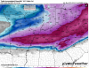
Ice ice babyFebruary 2014 flashbacks View attachment 69959


Effing sleet ??CAE still rains ! Lol View attachment 69962

CAE still rains ! Lol View attachment 69962
Oh Crap!!!
Yeah, I think that has to do with the TPV. The western part of the double barrel just sort of pinwheels in an unfavorable location. This is basically the same story we saw with the last setup: we really want ridging or nothing there with a trough/PV piece further east instead of doing... whatever this is.The SER is rapidly pushing the 850 line northward.

Me neither. That was freezing rain with temps 26-27. No bueno, especially with the amount of cold prior to the storm.I'll take it! I want no part of that ice!
February 2014 flashbacks (more organized system tho)View attachment 69959
Classic CAD Mixed Bag Slop storm. I WANT PURE POWDER! IT'S BEEN TOO LONG! LET'S NOT WASTE THIS COLD AIR!
I honestly think in reality, the snowpack will be much more in play than what this model run showed. In this scenario, with a Winter storm that just moved through NC, it would enforce the cold air for the second storm.Verbatim, the Euro actually looks better/more wintry than I expected. The snowpack to our north is likely really coming into play, getting rid of the marginal surface temp problems we've had all winter.
Look how the snow line runs horizontal until it gets to the Carolinas. Thanks, mountains.Classic CAD Mixed Bag Slop storm. I WANT PURE POWDER! IT'S BEEN TOO LONG! LET'S NOT WASTE THIS COLD AIR!
actually alot CAE would be in that ice but i don't want that crap anywayCAE still rains ! Lol View attachment 69962
Good for nothing except for giving us solid 33 degree Cad rains.Look how the snow line runs horizontal until it gets to the Carolinas. Thanks, mountains.
All kidding aside, if we assume (big grain, I know) the synoptic details that the Euro is seeing are correct, you know CAD areas will be even colder than shown when we get to it.
Oh ---- it was, woah12z Euro was a triple phaser at day 5-6.

Look how the snow line runs horizontal until it gets to the Carolinas. Thanks, mountains.
All kidding aside, if we assume (big grain, I know) the synoptic details that the Euro is seeing are correct, you know CAD areas will be even colder than shown when we get to it.
You are crazy.Give me the ice storm. Yeh, I said it.
Give me the ice storm. Yeh, I said it.