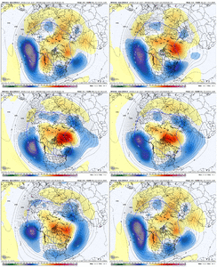
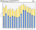
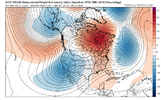
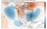
That’s actually a TPV… not a bad thing or location… it would help feed in cold airThat is an amazing look, well except for that pesky GL low
-
Hello, please take a minute to check out our awesome content, contributed by the wonderful members of our community. We hope you'll add your own thoughts and opinions by making a free account!
You are using an out of date browser. It may not display this or other websites correctly.
You should upgrade or use an alternative browser.
You should upgrade or use an alternative browser.
Pattern February 2024
- Thread starter SD
- Start date
- Joined
- Jan 23, 2021
- Messages
- 4,602
- Reaction score
- 15,197
- Location
- Lebanon Township, Durham County NC
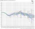
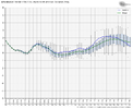
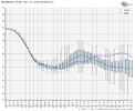
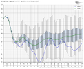
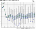
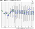
Just to add some graphs to @griteaters post, not only is the NAO and AO forecast to go negative on the weeklies, its forecast to go strongly negative. It may be more strongly negative than January.
If you’re not sure how to read that, it’s showing you the maximum and minimum of each forecast of the members of that suite. If you look on and around the 15th-20th, it’s showing that most of its members forecast at least a moderately strong negative NAO with some obviously going into severely negative territory. The thing that is most impressive, in my opinion on the AO, is that the strongest positive it’s showing roughly in that time frame is a +2 but with most of the time just around +1. That’s absolutely incredible.
You will get no argument from me that it’s been a long two years but if this is right, it’s not only a home run pattern. This is the Shohei Ohtani of patterns, IMO. You don’t see it come around much. Can it fall apart? Nothing is a given but me personally, and my limited knowledge of this stuff, I feel relatively confident that the streaks will end in many places.


Last edited:
^ By the way, I didn't mean for this to come across like "I think the pattern ahead looks really good, and because of that, you should too".....it was more like "I think the pattern looks really good, but I do see other viewpoints and skepticism here and elsewhere, so let's see what the data shows today and assess from there." Which, by the way, nothing has changed. Anyway, just wanted to get that off my chest. BoomI’m ready to throw all my chips in on this pattern ahead yet there are skeptics. Let’s see what today’s data provides
There really seems to be a consensus across the ensembles now of a -AO/-NAO/+PNA combo to go along with a favorable MJO. We’ve talked a lot about February 2015 when looking at this pattern potential. Remember the -NAO was the one ingredient that was missing that monthJust to add some graphs to @griteaters post, not only is the NAO and AO forecast to go negative on the weeklies, its forecast to go strongly negative. It may be more strongly negative than January.
If you’re not sure how to read that, it’s showing you the maximum and minimum of each forecast of the members of that suite. If you look on and around the 15th-20th, it’s showing that most of its members forecast at least a moderately strong negative NAO with some obviously going into severely negative territory. The thing that is most impressive, in my opinion on the AO, is that the strongest positive it’s showing roughly in that time frame is a +2 but with most of the time just around +1. That’s absolutely incredible.
You will get no argument from me that it’s been a long two years but if this is right, it’s not only a home run pattern. This is the Shohei Ohtani of patterns, IMO. You don’t see it come around much.
View attachment 144630
View attachment 144631
View attachment 144634
This is spot on and very well said. I also like the Thomas Wolfe quote that @Stormlover has as his profile signature.We enjoy it because it’s one of the most beautiful things that nature produces. It doesn’t happen often in the south, hence the reason so many people obsess and hope for it during the short few months we have to actually score a decent snow. The fact that we don’t get much is what makes it so much more enjoyable than if we got it all the time like they do up north. It usually melts within 3 days so it’s hardly a nuisance compared to say flooding or tornadoes and hurricanes.
It's funny this guy is hanging out on the forum, during winter and on a winter weather thread to boot, so take his objections for what they are worth. (Not too much....LOL)
This pattern is fun to watch unfold. A large amount of posters here, maybe short of the guy down in Key Biscayne, may have something to track over the next several weeks or so. Good luck to everyone. It never hurts!!!
AJ1013
Member
This is spot on and very well said. I also like the Thomas Wolfe quote that @Stormlover has as his profile signature.
It's funny this guy is hanging out on the forum, during winter and on a winter weather thread to boot, so take his objections for what they are worth. (Not too much....LOL)
This pattern is fun to watch unfold. A large amount of posters here, maybe short of the guy down in Key Biscayne, may have something to track over the next several weeks or so. Good luck to everyone. It never hurts!!!
Hey the 1977 snow down here did happen ya know. More seriously though living where I do I just don’t want it to be hot, when you guys win I (usually) also win. Last freeze here was in 1989, Coldest this century is 33F in Jan 2010, so for you all up north (but still in the south) just know it can always be worse!
That reminds me. Down here we have a saying, “drive north to go south”. Miami is the capital of latin america, zero southern culture, have to drive north a few hours to feel like you’re in the south lol.
Last edited:
ATLwxfan
Member
You know it’s a bad winter when the Winter Weather Support Group thread has been locked by the moderator.
Sent from my iPhone using Tapatalk
Sent from my iPhone using Tapatalk
I know it’s been depressing so far for many this winter. It’s frustrating especially coming out of a snowless winter.GEFS Extended with classic February split flow El Niño with retrograding block, wow. This is where I think the SPV weakening is key for maximizing the high latitude blocking potential
View attachment 144644
But … this pattern coming up for the second half of February and even into March looks legit. Will have many forgetting why they ever were so upset about this winter to start.
Winter looking to roar back in style.
Avalanche
Member
Yeah if you live up in Boone or Beech Mnt I can see them eeking out a few flakes before SpringI know it’s been depressing so far for many this winter. It’s frustrating especially coming out of a snowless winter.
But … this pattern coming up for the second half of February and even into March looks legit. Will have many forgetting why they ever were so upset about this winter to start.
Winter looking to roar back in style.
Avalanche
Member
Relax guys just a joke!!!! LolYeah if you live up in Boone or Beech Mnt I can see them eeking out a few flakes before Spring
Tarheelwx
Member
I’ll preface this statement with the fact that I really don’t pay attention to the ensembles except in the winter and it is when they are posted here or on the other board. But, once again the operational outperformed the ensembles. The GFS went south quite a while ago as so many folks pulled out the “disregard the operational at this range and use the ensembles” argument/strategy. Just saying that more often than not when I hear this statement, the operational(s) ends up being more accurate. Has anyone else seen to have experienced the same?
TW
TW
Prestige Worldwide
Member
PV split?
I think you gotta take it in context. First of all, I give no credence whatsoever to the GFS beyond day 7 as ever being a viable solution and that honestly is pushing it…I never really pay much attention to the EURO after 7 days either. Sure we look at at them and think what might be possible during that time frame, but if an operational shows a solution that it’s ensembles don’t support in anyway, you can pretty much write it off. Here though there was a storm signal in the ensembles, there absolutely was a signal for suppression as well and that will end up being which way it breaks. I think the mistake that a lot of people make when looking at ensembles is focusing on the mean number of something rather than the total members showing something… for example if the GEFS gives me a snowfall mean of 2” when it’s 7-8 days out it’s sounds really good. However if there’s only one or two members showing a huge 12”+ total and the rest showing nothing, then that’s really not a good storm signal at all.I’ll preface this statement with the fact that I really don’t pay attention to the ensembles except in the winter and it is when they are posted here or on the other board. But, once again the operational outperformed the ensembles. The GFS went south quite a while ago as so many folks pulled out the “disregard the operational at this range and use the ensembles” argument/strategy. Just saying that more often than not when I hear this statement, the operational(s) ends up being more accurate. Has anyone else seen to have experienced the same?
TW
I’d agree because usually on the ensembles you get a lot of snow hits scattered around and we all know it doesn’t snow around here. The operational runs rarely show snow which is why they are closer the the real outcome more times than notI’ll preface this statement with the fact that I really don’t pay attention to the ensembles except in the winter and it is when they are posted here or on the other board. But, once again the operational outperformed the ensembles. The GFS went south quite a while ago as so many folks pulled out the “disregard the operational at this range and use the ensembles” argument/strategy. Just saying that more often than not when I hear this statement, the operational(s) ends up being more accurate. Has anyone else seen to have experienced the same?
TW
Last edited:
If you look at how that progressed though over that week, you can see how the beginning of that with the brief warm up is how the -NAO gets established. The SER briefly flexes before it gets muted by the strong STJ, and the taller heights get forced up to Greenland establish the blocking. I’ve said it several times. The SER might flex a little at times but with this strong El Niño STJ, it gets pushed down rather quickly.Quick warmup is coming. Let’s just hope and pray we can get from this:View attachment 144700
To this:View attachment 144699
as quickly as possible. We’re running out of time fast.
Going to need a Feb 2015 repeat to save this winter.
GoDuke
Member
Followed by a March 1960.Going to need a Feb 2015 repeat to save this winter.
lexxnchloe
Member
We have been hearing about a pattern change since mid dec and it hasnt happened yet and likely wont until late march. Dec was +4.6 and Jan +3.4. So for the first 2 months of winter its been warm. A pattern change to me means 2 full months averaging below normal and its already way too late for that to even matter. Maybe next winter jan/feb will avg below normal. Thats a pattern change
OkWe have been hearing about a pattern change since mid dec and it hasnt happened yet and likely wont until late march. Dec was +4.6 and Jan +3.4. So for the first 2 months of winter its been warm. A pattern change to me means 2 full months averaging below normal and its already way too late for that to even matter. Maybe next winter jan/feb will avg below normal. Thats a pattern change
The issue I have with Niño winters or really just the pattern we have now is you have an active southern stream that’s low pressure dominant and you’re relying on a low bombing off the northern stream to drag cold air down to meet up with a SS wave. Some sort of perfectly timed phase is your only shot. You never really even get an opportunity to slide high pressure into the setup which is what you want to see for your best snow chances for us snow deprived eastern posters. MSLP maps are just one big blue ball up and down the east coast and it’s been that way all winter. This ain’t it.
0z EPS moved it closer last night to just passed day 10.Is this upcoming 'favorable condition' already getting delayed to later in the month now?
When it gets inside day 10 we can start celebrating. I do think the pattern changes but odds of snow is another story.We have been hearing about a pattern change since mid dec and it hasnt happened yet and likely wont until late march. Dec was +4.6 and Jan +3.4. So for the first 2 months of winter its been warm. A pattern change to me means 2 full months averaging below normal and its already way too late for that to even matter. Maybe next winter jan/feb will avg below normal. Thats a pattern change
*therapist turns to the board* and is the pattern change in the room with us right now?
Obviously it’s your opinion, but when you consider that CLT, GSO, RDU, and GSP all average more snowfall and more days with snow being recorded in El Niño years than both La Niña and neutral years, there must be something good about El Niños.The issue I have with Niño winters or really just the pattern we have now is you have an active southern stream that’s low pressure dominant and you’re relying on a low bombing off the northern stream to drag cold air down to meet up with a SS wave. Some sort of perfectly timed phase is your only shot. You never really even get an opportunity to slide high pressure into the setup which is what you want to see for your best snow chances for us snow deprived eastern posters. MSLP maps are just one big blue ball up and down the east coast and it’s been that way all winter. This ain’t it.
Definitely some decent noise around Valentine’s Day of some sort of Miller A on the EPS/GEFS.
No… all the teleconnections…AO, NAO, PNA, and MJO are still progressing the same they have been.Is this upcoming 'favorable condition' already getting delayed to later in the month now?
- Joined
- Jan 23, 2021
- Messages
- 4,602
- Reaction score
- 15,197
- Location
- Lebanon Township, Durham County NC
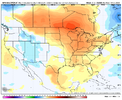
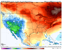
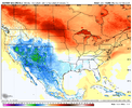
Yes, pattern starting to change day 10-12 but temps will take longer to respond. And I do think we see a solid cold shot like we did for a week in January but avg's are 7-8F higher to end Feb than mid January.
View attachment 144707
View attachment 144706
It definitely could be, but a slow step down in temps very rarely happens like the smoothed out ensembles suggest but also on the flip side the patterns suggested can also look much longer as well.
That said, Im gonna ride with H5 over temp anomalies right now.
- Joined
- Jan 23, 2021
- Messages
- 4,602
- Reaction score
- 15,197
- Location
- Lebanon Township, Durham County NC
One thing that was hammered home to me when I was under the learning tree of mets on WWBB is that the surface catches up to H5 and not vice versa.It definitely could be, but a slow step down in temps very rarely happens like the smoothed out ensembles suggest but also on the flip side the patterns suggested can also look much longer as well.
That said, Im gonna ride with H5 over temp anomalies right now.
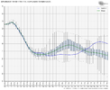
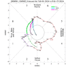
One of the biggest things that sticks out to me is the nosedive the AO is about to take. It basically peaks in positive territory today and tomorrow before drops and drops fast. It certainly makes sense that we’re seeing a strong consensus for SPV split in the modelsEvery teleconnection I can possibly find
View attachment 144708
View attachment 144709
View attachment 144710
View attachment 144711
View attachment 144713
- Joined
- Jan 23, 2021
- Messages
- 4,602
- Reaction score
- 15,197
- Location
- Lebanon Township, Durham County NC
The weeklies graph I posted last night was absolutely incredible. That 6z GEFS image isnt too far off.One of the biggest things that sticks out to me is the nosedive the AO is about to take. It basically peaks in positive territory today and tomorrow before drops and drops fast. It certainly makes sense that we’re seeing a strong consensus for SPV split in the models
This is something my next door neighbor, a retired Navy met, has said on a number of times. He once told that me that he never even looks at a surface temperature map past day 10.One thing that was hammered home to me when I was under the learning tree of mets on WWBB is that the surface catches up to H5 and not vice versa.
One thing that was hammered home to me when I was under the learning tree of mets on WWBB is that the surface catches up to H5 and not vice versa.
Honestly we need Fro or one of our other “pay for extra models” guys to post an all individual ensemble frame temp anomaly chart to give us better insight. *hint hint*
coldfront22
Member
Looks very warm mid-month. Does everyone expect those temps to decrease as the models get a better handle on the AO nosedive? Models looked much colder in the extended yesterday.

